In this modern society’s substructure, roads behave as the key medium for transportation and lending a great deal to the allocation of goods, funds and individuals. The trend of urbanization, the increase in population and increase in number of registered vehicles on roads induces pressure on traffic movements and causing the traffic congestion problem on roads in almost every part of the world which makes living in urban area more difficult. Application of GIS in road traffic management renders many useful functions for assuring an efficient flow in the traffic systems of a country. In this post we are going to discuss about the Traffic Congestion Modelling – GIS . but let’s first talk about what actually is Traffic Congestion.
What is Traffic Congestion?
Congestion is a possibility for any mode of transportation, Traffic congestion is a condition on transport networks. When traffic demand on road is great enough that the interaction between vehicles slows the speed of the traffic stream, this results in some congestion.
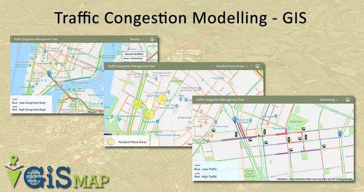
Traffic Congestion Modelling – GIS
The Traffic Congestion Modelling is the strategic planning to influence the traffic with the monitoring and control over the traffic systems. The traffic congestion management is used to expand the potential of State and local transportation systems. Traffic congestion management is one of the tough task of the local authorities because of the rapid urbanization. Improper traffic management and planning may lead to severe traffic congestion and accidents in the city. For inventing and implementing new solution on such problems it is necessary to get current traffic data and right decision making tool. In recent years, GIS has emerged as one of the most efficient tools in the transportation sector and GIS is one of the management decision making tool which analyses stores huge amount of data efficiently and effectively. Expected project output will be the recommendation for better traffic management using GIS tool on the basis of data collected, analysis and design.
Benefits of Traffic Congestion Modelling – GIS
- Effortlessness movement of traffic
- Minimum time spent on roads due to traffic
- Improving the travelling mobility
- Increased roadway safety and personal protection
- Efficient transport planning and designing
- Reliable and safe operation of transport
- Conserving the energy while protecting the environment
GIS can help in the assessment and management of traffic congestion by mapping out these various factors that influence the speed of moving vehicles, like width of road, construction work, road’s structure, various land uses that attract vehicle traffic. GIS represent the modern entry of multi-discipline fields in subject areas like computer science, surveying, geography, and cartography into statistical analysis and the management of transportation systems.
Use of Traffic Congestion Modelling – GIS
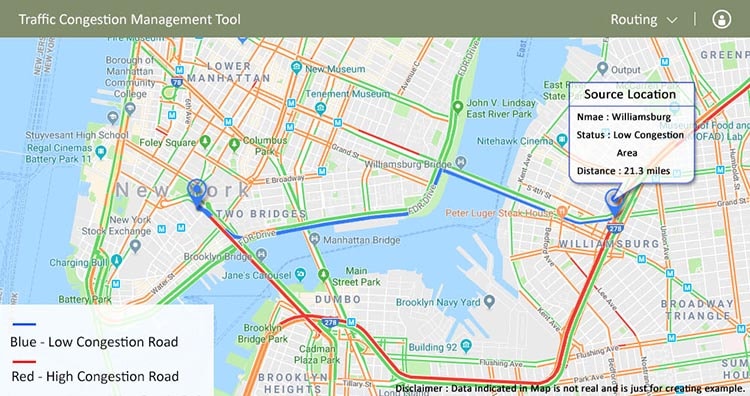
- Routing with GIS: GIS provides alternative routes to road user so that they don’t get in any congestion on road. Roads and traffic information is crucial data and road traffic mangers normally organize this material by compelling the data into table used in statistical analysis. spatial analysis, allows the tool to start responding to various events, evaluate impact and answers the best route for the road users.

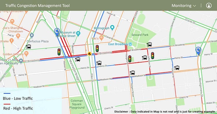
- Monitoring with GIS: GIS can render large database easily, which can integrate data from disparate sources. The monitoring allows the tool for proper signal controlling on busy or congestion squares. for example if Square A shows as the congestion spot with high congestion, then for reducing the congestion of square A, we can divert the traffic coming to this square by using proper signalling of near by square B and square C with low congestion with the help of monitoring. Monitoring helps us understand the right timing and how can we properly control the signals, which can help in Traffic congestion model.
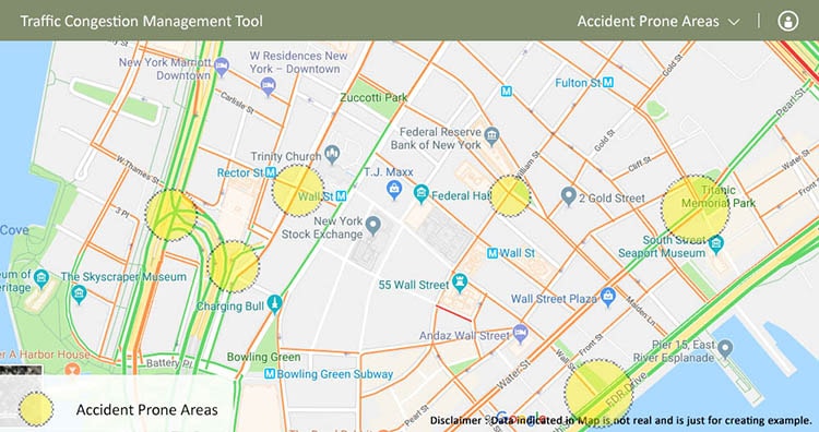
- Accidents minimization : In Traffic Congestion Management, accidents can be minimized via GIS by generating a data of most accidents prone spots. The information can be provided either in the graphical format to the users or user’s driver and when the users gets the information about nearest dangerous area the drivers become extra cautious at such spots hence free flow can be maintained.
- Reduction of Congestion spots : GIS is one of the powerful tools for analysis the spatial and attribute data for effective traffic management. Regional
planning is essential for proper transportation management. GPS data was used to identify the spatial location of traffic congestion and other location based spatial information. One of the useful GIS functions to be used for this purpose is known as shortest path. It refers to the process of creating map of the shortest path from one point to another. The GIS tool requires that the user should have road direction table containing a list of directions stored as a database table as well as a set of reference data such as roads on which the addresses can be located. This can help in Reducing the congestion spots on the roads by providing the shortest and easiest part to the user.
GIS has a wide variety of applications in road traffic direction and traffic planning in transportation networks. GIS is a bonus to all sorts of traffic direction; the blending of GIS with other schemes is perhaps the best principal potential for the expectations of GIS. The priority results are utilized in evaluating congestion points according to roads direction. Results obtained from this tools compare alternate improvement strategies, and solutions thus giving the best possible solution. This is how you can use GIS in Traffic Congestion Modelling.
Do let us know how this Article is helpful for you, by commenting below in the comment box.
what about land lease and its rules in Ethiopia?