In Telecommunication ‘tele’ comes from Greek means far off and ‘communication’ means exchange of information using some medium. Location information is elemental for telecommunication and GIS in Telecom is widely accepted. Geographical Information System tools manages and analyzes the location of dp junction, available ports, fiber cables lines on the map that increases efficiency of the system.
Locate DP Junction, Ports, Fiber Cable, Connected House – GIS Telecom using IGIS Map Tool
Now we will learn how can we use igis map tool in telecom industry. Go to IGIS Map Tool and login with credentials or register with valid email id.
- Create a map using ADD MAP button.

- Fill the Tittle of the map with description about the map.

- Now you will be redirected to the canvas of IGIS Map. Here on the base map you see the plot number.

- Now create a DP – distribution Point using point layer. Tap on Point icon shown below.

- Fill the Layer Name. Add attributes for name of the distribution point and ports. You can add multiple ports to a junction.

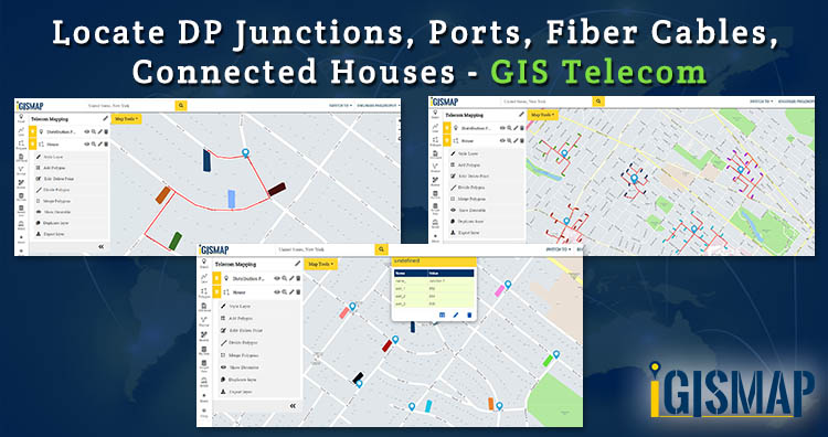
- After creating layer go to Add Point in the drop down of layer. Add point in the map. Now create a Polygon layer with attributes. If you are problem in creating layer then check – Create Map layer – Point, Polygon, Line. In the below image we have created multiple junction and houses with fiber cable connections. This type of visualization make your analyzation fast.

- You can get information about the connected house to which port by clicking on junction point. Through this you can track the line if any issues occur at end users.

- You can either upload fiber line data (shapefile or any GIS format data) or create line layer. And style your map as per desire. In the below image you can see various DP Junction connected to multiple houses. Fiber cables are also created in the image using line layer.

This is all about of locating DP Junctions, Ports, fiber cables and connected houses in GIS Telecommunication. If you are facing problem in execution then please do comment below.
We also provide customized products as per your needs. Contact us at juhi@igismap.com for information.
You can also watch video for implementation of the steps –
Some more with IGIS Map Tool