Need spatial data for agricultural or environmental planning? Download Orchard Data effortlessly using GIS Data by MAPOG—a comprehensive platform offering multi-format GIS datasets including Shapefile, KML, GeoJSON, MID, and more. Designed to support diverse GIS tools, this intuitive portal delivers well-structured, location-specific data on orchards, ideal for land use studies, farming analysis, agri-tech solutions, and sustainable development planning.
How to Download Orchard Data with MAPOG
MAPOG simplifies access to orchard-related geographic data with a straightforward, guided workflow. With support for formats like SHP, KML, CSV, MID, DXF, MIF, GPX, and TOPOJSON, it serves the needs of both professionals and enthusiasts in the GIS and agriculture sectors.
Download Orchard Data of any countries
Note:
- All data is provided in GCS datum EPSG:4326 WGS84 CRS (Coordinate Reference System).
- Users need to log in to access and download their preferred data formats.
Step-by-Step Guide to Download Orchard Data
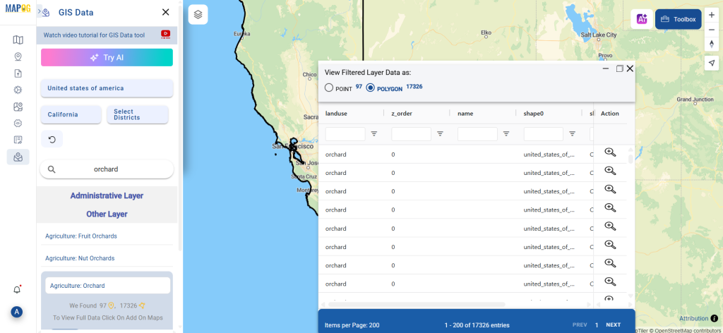
Step 1: Search for Orchard Data
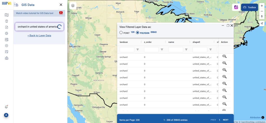
Navigate to the MAPOG platform and use the search layer tool to locate “Orchard Data.” Once found, review its attributes to confirm whether the data is represented in points or polygons. This helps determine its suitability for your intended GIS application.
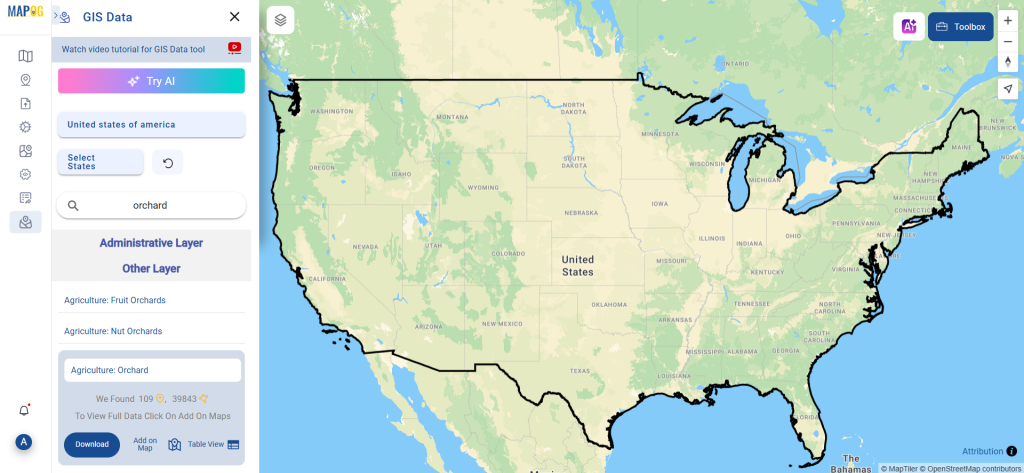
Step 2: Try the AI Search Assistant
Save time by using MAPOG’s “Try AI” feature. Input simple prompts like “Orchards in this area” and let the AI fetch the most relevant layers in seconds. This smart search assistant improves accuracy and reduces the hassle of manual filtering.
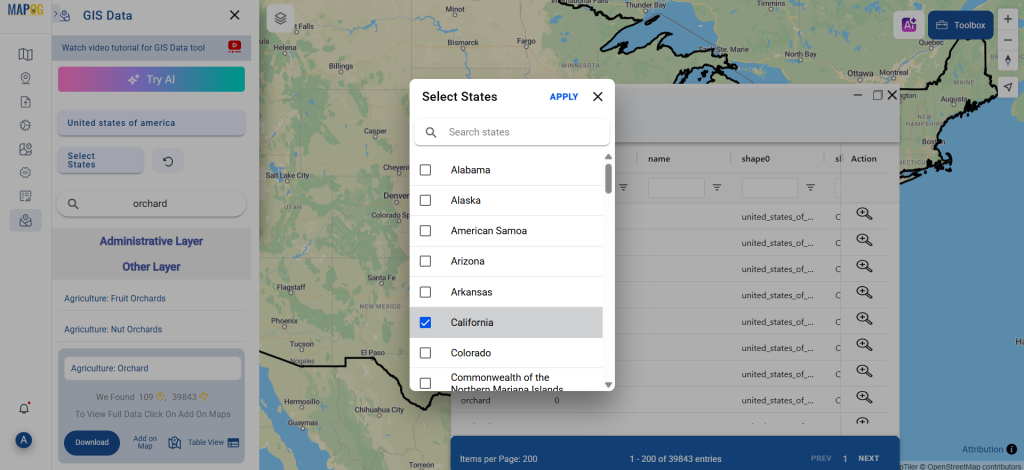
Step 3: Apply Smart Filters for Precision
Make your search more specific with the Filter Data option. Users can narrow down orchard datasets by selecting specific states or districts—helping target the exact region of interest. For country-wide datasets, these filters allow deeper granularity and improved data relevance.
Step 4: Visualize the Data on the Map
The “Add on Map” feature allows you to overlay the selected orchard data on the interactive map interface. This visual layer helps with spatial analysis, planning, and pattern recognition—especially useful for comparing orchard distribution or coverage across regions.
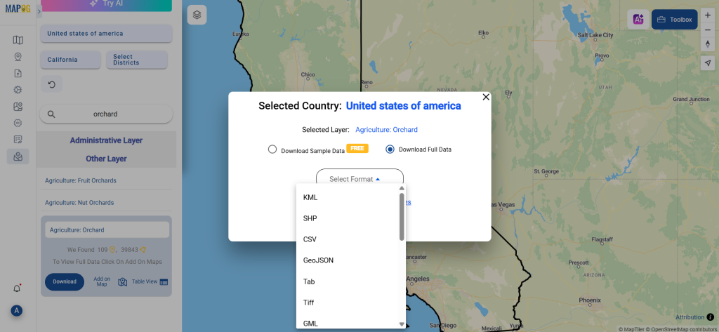
Step 5: Download Orchard Data in Desired Format
Once you’re satisfied with the dataset, proceed to download it. Choose between sample or full versions, select your preferred format—whether Shapefile, KML, MID, or another GIS-supported type—and agree to the download terms. With just a click, your orchard data is ready to use.
Final Thoughts
Thanks to MAPOG’s intuitive tools and extensive format support, the process to download Orchard Data is seamless and efficient. Whether you’re mapping for agriculture, conducting environmental assessments, or managing land resources, the platform ensures you get accurate and useful orchard data tailored to your needs. So if you’re ready to take your GIS analysis to the next level, start by downloading the orchard data that fits your project perfectly.
With MAPOG’s versatile toolkit, you can effortlessly upload vector and upload Excel or CSV data, incorporate existing layers, perform polyline splitting, use the converter for various formats, calculate isochrones, and utilize the Export Tool.
For any questions or further assistance, feel free to reach out to us at support@mapog.com. We’re here to help you make the most of your GIS data.
Download Shapefile for the following:
- World Countries Shapefile
- Australia
- Argentina
- Austria
- Belgium
- Brazil
- Canada
- Denmark
- Fiji
- Finland
- Germany
- Greece
- India
- Indonesia
- Ireland
- Italy
- Japan
- Kenya
- Lebanon
- Madagascar
- Malaysia
- Mexico
- Mongolia
- Netherlands
- New Zealand
- Nigeria
- Papua New Guinea
- Philippines
- Poland
- Russia
- Singapore
- South Africa
- South Korea
- Spain
- Switzerland
- Tunisia
- United Kingdom Shapefile
- United States of America
- Vietnam
- Croatia
- Chile
- Norway
- Maldives
- Bhutan
- Colombia
- Libya
- Comoros
- Hungary
- Laos
- Estonia
- Iraq
- Portugal
- Azerbaijan
- Macedonia
- Romania
- Peru
- Marshall Islands
- Slovenia
- Nauru
- Guatemala
- El Salvador
- Afghanistan
- Cyprus
- Syria
- Slovakia
- Luxembourg
- Jordan
- Armenia
- Haiti And Dominican Republic
- Malta
- Djibouti
- East Timor
- Micronesia
- Morocco
- Liberia
- Kosovo
- Isle Of Man
- Paraguay
- Tokelau
- Palau
- Ile De Clipperton
- Mauritius
- Equatorial Guinea
- Tonga
- Myanmar
- Thailand
- New Caledonia
- Niger
- Nicaragua
- Pakistan
- Nepal
- Seychelles
- Democratic Republic of the Congo
- China
- Kenya
- Kyrgyzstan
- Bosnia Herzegovina
- Burkina Faso
- Canary Island
- Togo
- Israel And Palestine
- Algeria
- Suriname
- Angola
- Cape Verde
- Liechtenstein
- Taiwan
- Turkmenistan
- Tuvalu
- Ivory Coast
- Moldova
- Somalia
- Belize
- Swaziland
- Solomon Islands
- North Korea
- Sao Tome And Principe
- Guyana
- Serbia
- Senegal And Gambia
- Faroe Islands
- Guernsey Jersey
- Monaco
- Tajikistan
- Pitcairn
Disclaimer : The GIS data provided for download in this article was initially sourced from OpenStreetMap (OSM) and further modified to enhance its usability. Please note that the original data is licensed under the Open Database License (ODbL) by the OpenStreetMap contributors. While modifications have been made to improve the data, any use, redistribution, or modification of this data must comply with the ODbL license terms. For more information on the ODbL, please visit OpenStreetMap’s License Page.
Here are some blogs you might be interested in:
- Download Airport data in Shapefile, KML , MIf +15 GIS format – Filter and download
- Download Bank Data in Shapefile, KML, GeoJSON, and More – Filter and Download
- Download Railway data in Shapefile, KML, GeojSON +15 GIS format
- Download Farmland Data in Shapefile, KML, GeoJSON, and More – Filter and Download
- Download Pharmacy Data in Shapefile, KML, GeoJSON, and More – Filter and Download
- Download ATM Data in Shapefile, KML, MID +15 GIS Formats Using GIS Data by MAPOG
- Download Road Data in Shapefile, KML, GeoJSON, and 15+ GIS Form