Effortlessly convert KML to SHP with MAPOG to streamline your geographic data transformation for enhanced spatial analysis and interoperability.
Transforming your GIS data by converting KML to SHP can simplify analysis, sharing, and integration into various GIS applications. Whether you’re a beginner or an experienced user, this tutorial will guide you through the process in easy steps.
Converting KML to SHP with MAPOG
KEY CONCEPT OF CONVERTING FILES
The Converter Tool in MAPOG allows you to change your data from one format to another effortlessly. You input your data in one form, and it transforms it into the required format for your analysis. This versatility enables you to download and use data in various formats, making it adaptable for different applications.
STEPS TO CONVERT KML TO SHP WITH MAPOG
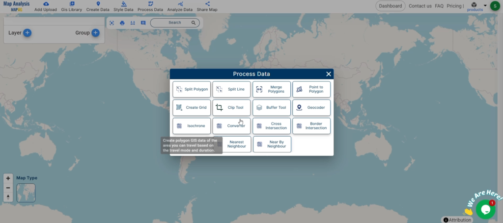
STEP 1: UPLOAD THE DATA
Access the Converter Tool: Click on the “Process Data” menu and choose the “Converter Tool” option.
Access the Converter Tool
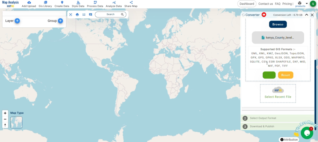
Upload KML File: This is your starting point where you provide the data that needs conversion.
Upload KML File
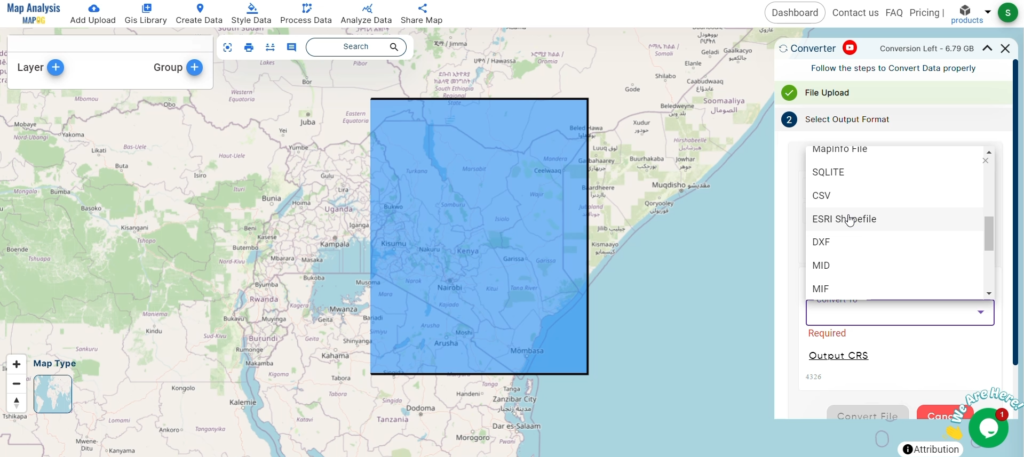
STEP 2: SELECT THE FORMAT FOR CONVERSION
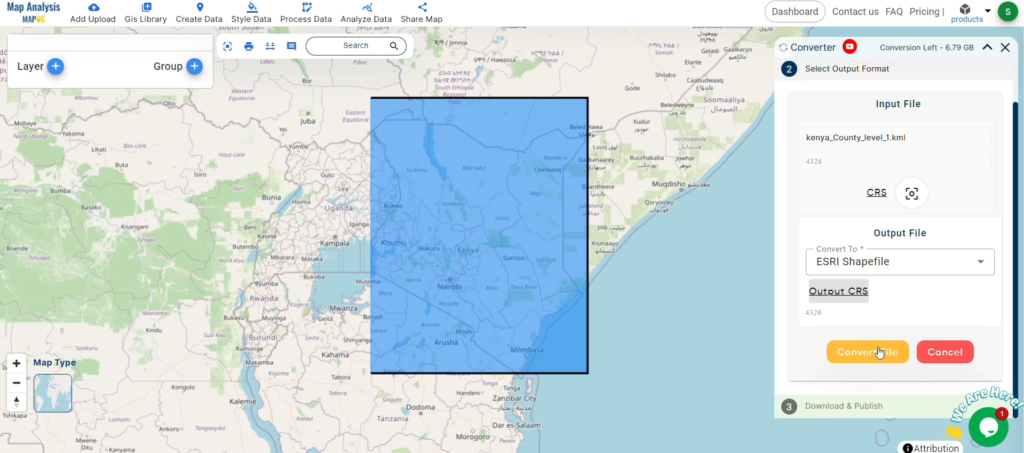
Choose the Output File Format: Select SHP as the output file format. The tool offers various formats, but for this guide, we focus on converting to SHP.
Choose the Output File Format
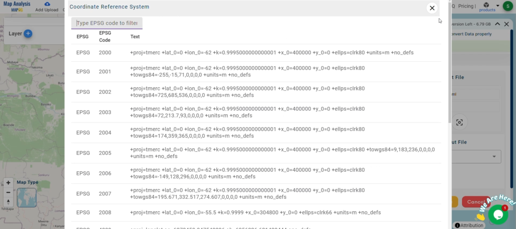
Set the CRS (Coordinate Reference System): You can also set the CRS at this stage to ensure your data aligns correctly with your spatial analysis requirements.
Set the CRS (Coordinate Reference System)
STEP 3: RUN THE CONVERSION
Start the Conversion Process: Click ‘Convert’ and let the tool work its magic. The Converter Tool processes your data, transforming it from KML to SHP format.
RUN THE CONVERSION
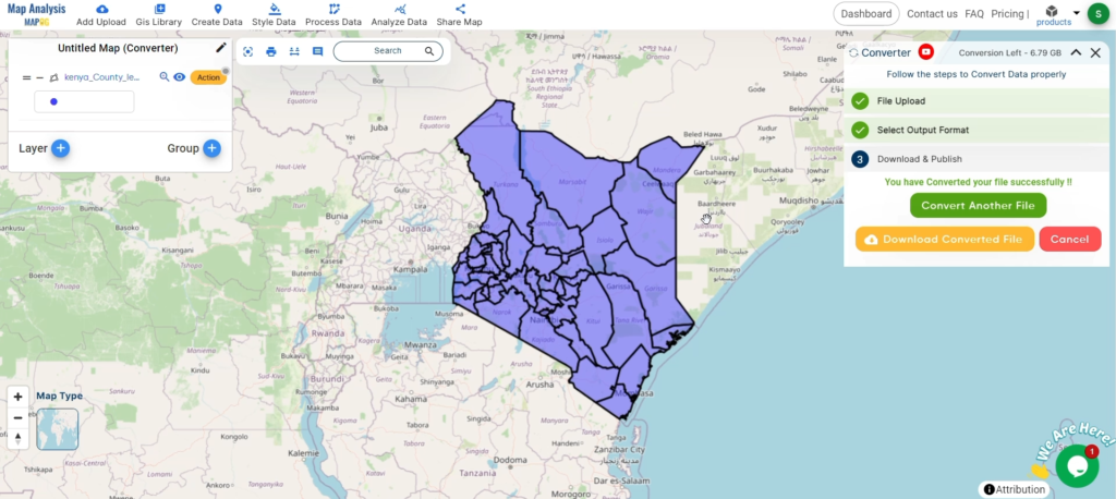
STEP 4: REVIEW AND DOWNLOAD
Review the Converted Data: Check your converted SHP data to ensure it looks correct. This step is crucial to verify that the conversion has been successful and the data integrity is maintained.
And there you have it! You’ve successfully used the Converter Tool in MAPOG Map Analysis to convert your KML files to SHP. This conversion simplifies the process of handling different data formats and makes your workflow more efficient and effective. For any queries, please contact us at support@mapog.com.
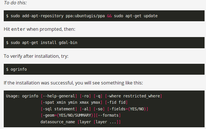
Convert kml to shp shapefile. Have you extracted and downloaded kml file from Google Earth or Google map and want to render it with your geo library which support shapefile? Do you have KML data given from third party and want to give a proper representation of data over map by converting the same in shapefile? If so, here is an article to convert kml to shp using command line tool ogr2ogr or using php code. While if you use QGIS tool, you can look over kml to shp convert using QGISor else continue using this article.
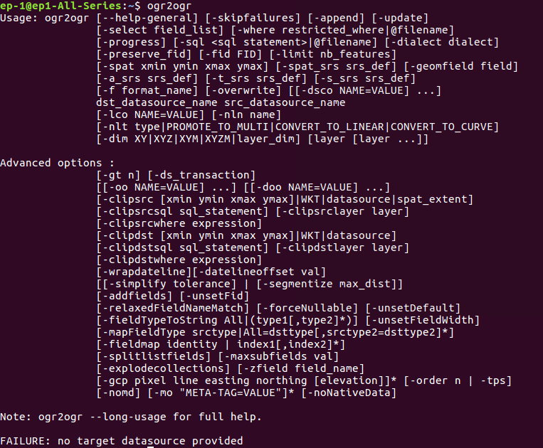
KML (Keyhole Markup Language)is very popular GIS format. It is available in text format containing tags such as Placemark, SimpleField, SimpleData and ExtendedData etc. It contains whole information in tag. But when you need to see the geometry you may require Shapefile. This conversion can be done using Ogr2ogr utility from GDAL (Geospatial Data Abstraction Library) and other GIS software such as QGIS, ArcGIS etc.
Convert kml to shp – Look Details For KML (Keyhole Markup Language) structure with Line feature-
In the above given example, attribute fields are given with their data type. In style tag geometry style shown with color. Extended Data encloses attribute field name with values. In the last coordinates are given for particular line string. In similar way other lines, point and polygon are given in KML.
Here -f defines the output file format and ‘ESRI shapefile’ is driver available.
PHP code for converting KML to SHP shapefile-
If you want the conversion using programing or don’t want to use terminal then this can also be done using PHP. You can create a function that defined this command as string and can give this string in shell_exec() method to execute. Shell_exec() actually execute the command and returns output as string.
public function KML_to_shp($KMLfilepath,$output){
 $query="ogr2ogr -f 'ESRI Shapefile'  $output.gml  $KMLfilepath";
 shell_exec($query);
 }
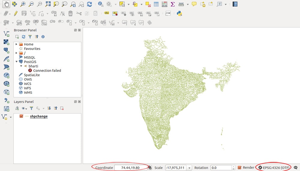
Generated output in QGIS software-
KML to SHP Shapefile – Convert
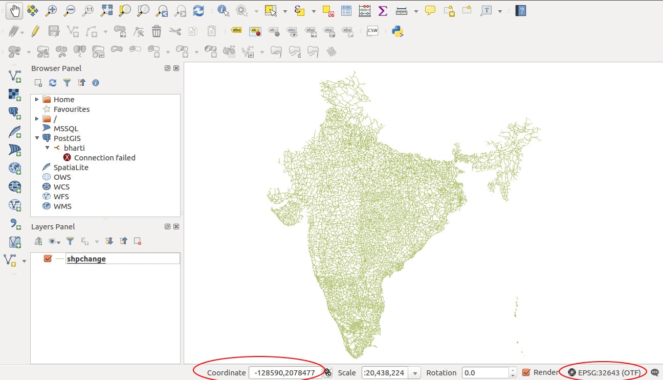
Change Coordinate System of shapefile generated from kml-
Changing coordinate system of output file can be done with this same ogr2ogr utility. It has various option for SRS (Spatial reference system), given below
Convert KML to Shapefile in QGIS. KML or Keyhole markup language file which store and models geographic features for displaying in Google earth or Google maps, which is not common in use for Map makers and GIS programmers. ESRI made a standard Vector file i.e Shapefile which is most commonly adopted in the field of GIS (Geographic Information System), and this made me to convert KML to shapefile, created for learning purpose from Google map. QGIS (Qunatum GIS) is an open source GIS tool, which provide you a function to convert the KML file to Shapefile, and Vice versa i.e Shapefile to kml file.
You might be looking for converting KML to shapefile when you get the data from third party or from website which download free GIS map data but in different formats which can also be converted to.
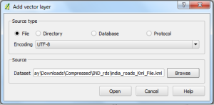
1.) Open up the installed QGIS. 2.) Select Layer in the menu bar and press Add Vector Layer or select the shortcut icon. Browse the KML file, in the Source DataSet type, in the pop up window opened.(While browsing, select either all files or Key Hole Markup language in file type). And press Open.
Convert KML to Shapefile in QGIS
Select the coordinate reference type system if coordinate reference window pop ups and press ok.
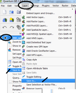
3.) In the Layer file appearing in the left upper side, right click on it, and select save as:
or
you can either select layer from the menu and click on save as.
Convert KML to Shapefile in QGIS
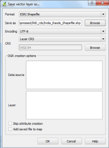
4.) In the Save vector layer as window, Select the format from the drop down box as ESRI Shapefile(OGR) and browse the folder in which you want to save the shapefile. Name it and Press OK.
Your Shapefile i.e .shp, .shx and .dbf file will be created in the directed folder. Upload your KML file in your map browser tool, or try our tool, to verify whether the tool preserves all attributes and elements or not. You may also see how to merge two shapefile in QGIS. Or if you are looking to convert that shapefile to kml to Topojson then you can look for GeoJSON to Topojson and Shapefile to GeoJSON and shapefile to TopoJSON. Do comment below if you are getting any problem in converting the file.
Loading Comments...
We use cookies to ensure that we give you the best experience on our website. If you continue to use this site we will assume that you are happy with it.