Finding accurate gym locations for GIS mapping is now easier than ever. Download Gyms Data in multiple formats like Shapefile, KML, and GeoJSON using GIS Data by MAPOG. This user-friendly platform provides access to a vast range of GIS data, enabling fitness professionals, urban planners, and businesses to analyze gym locations efficiently. Whether you’re mapping gym networks for a specific city or planning fitness infrastructure, MAPOG ensures seamless access to high-quality geographic datasets.
How to Download Gyms Data?
GIS Data by MAPOG simplifies the process with an intuitive interface. With data from over 200 countries and more than 900 layers, you can easily filter and download gym-related information.
Download Gyms data of any countries
Note:
- All data is provided in GCS datum EPSG:4326 WGS84 CRS (Coordinate Reference System).
- Users need to log in to access and download their preferred data formats.
Step-by-Step Guide to Download gyms Data
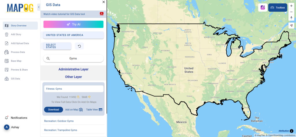
Step 1: Search for ‘Gyms Data’
Log in to MAPOG GIS Data and select your country. Use the search option to find Gyms data by entering relevant keywords. Whether you’re looking for gym locations in the USA, UK, Canada, or Australia, this tool provides precise results.
Step 2: Utilize the AI Search Feature
Save time by using the “Try AI” feature in the top-left corner. Simply enter the type of data you need and the location. The AI tool quickly fetches relevant results, streamlining your search process.
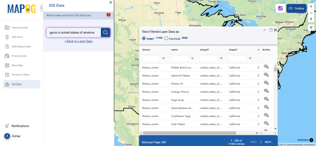
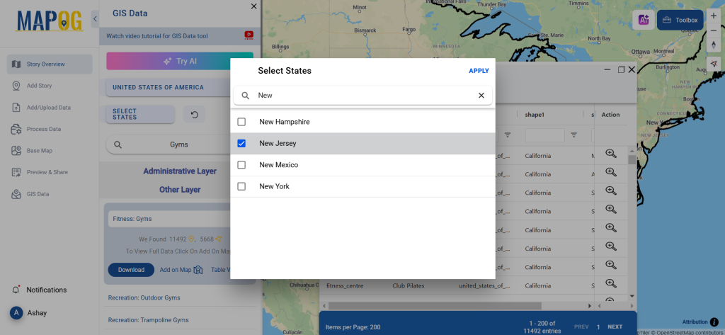
Step 3: Refine Data Using Filters
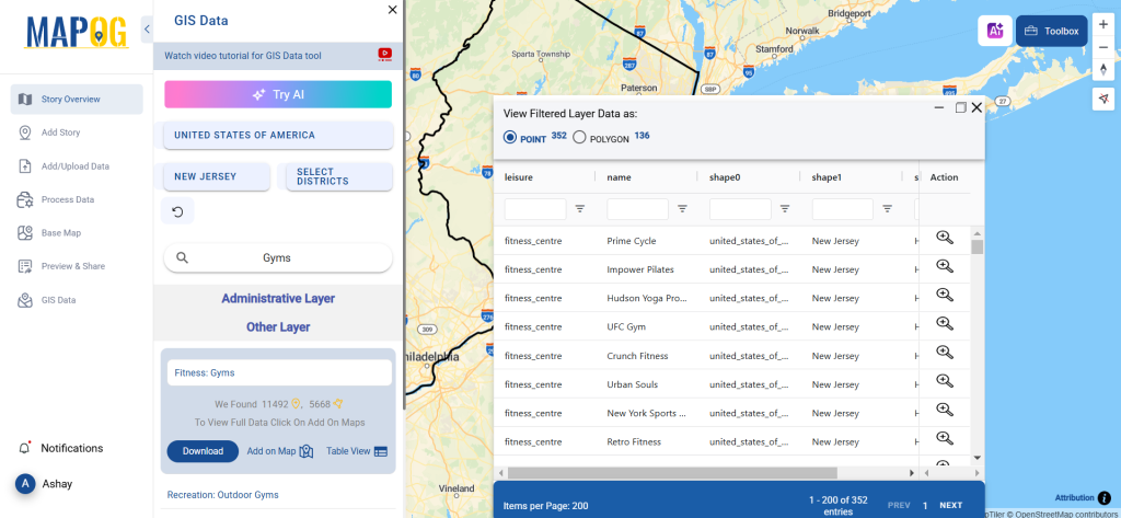
For better accuracy, use the Filter Data option. This lets you narrow down gym data based on state, city, or district.
Step 4: Visualize on Map
With the “Add on Map” feature, you can instantly visualize gym locations within the GIS interface. This enhances spatial analysis, allowing you to identify density patterns, accessibility, and proximity to other urban amenities.
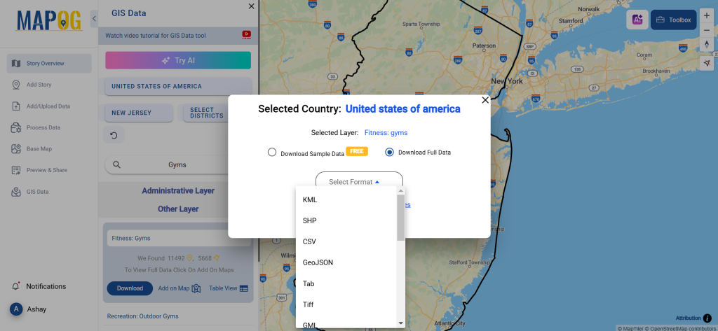
Step 5: Download in Preferred Format
Click “Download Data” and choose between sample or full datasets. Select from multiple formats, including Shapefile (SHP), KML, MID, GeoJSON, CSV, SQL, KMZ, GPX, and more. After agreeing to the terms, finalize the download.
Conclusion
With GIS Data by MAPOG, downloading Gyms Data for GIS mapping is effortless. Whether you’re a fitness entrepreneur, researcher, or urban planner, this tool provides accurate and accessible gym datasets in multiple formats. Start mapping today and unlock valuable insights into fitness infrastructure worldwide.
With MAPOG’s versatile toolkit, you can effortlessly upload vector and upload Excel or CSV data, incorporate existing layers, perform polyline splitting, use the converter for various formats, calculate isochrones, and utilize the Export Tool.
For any questions or further assistance, feel free to reach out to us at support@mapog.com. We’re here to help you make the most of your GIS data.
Download Shapefile for the following:
- World Countries Shapefile
- Australia
- Argentina
- Austria
- Belgium
- Brazil
- Canada
- Denmark
- Fiji
- Finland
- Germany
- Greece
- India
- Indonesia
- Ireland
- Italy
- Japan
- Kenya
- Lebanon
- Madagascar
- Malaysia
- Mexico
- Mongolia
- Netherlands
- New Zealand
- Nigeria
- Papua New Guinea
- Philippines
- Poland
- Russia
- Singapore
- South Africa
- South Korea
- Spain
- Switzerland
- Tunisia
- United Kingdom Shapefile
- United States of America
- Vietnam
- Croatia
- Chile
- Norway
- Maldives
- Bhutan
- Colombia
- Libya
- Comoros
- Hungary
- Laos
- Estonia
- Iraq
- Portugal
- Azerbaijan
- Macedonia
- Romania
- Peru
- Marshall Islands
- Slovenia
- Nauru
- Guatemala
- El Salvador
- Afghanistan
- Cyprus
- Syria
- Slovakia
- Luxembourg
- Jordan
- Armenia
- Haiti And Dominican Republic
- Malta
- Djibouti
- East Timor
- Micronesia
- Morocco
- Liberia
- Kosovo
- Isle Of Man
- Paraguay
- Tokelau
- Palau
- Ile De Clipperton
- Mauritius
- Equatorial Guinea
- Tonga
- Myanmar
- Thailand
- New Caledonia
- Niger
- Nicaragua
- Pakistan
- Nepal
- Seychelles
- Democratic Republic of the Congo
- China
- Kenya
- Kyrgyzstan
- Bosnia Herzegovina
- Burkina Faso
- Canary Island
- Togo
- Israel And Palestine
- Algeria
- Suriname
- Angola
- Cape Verde
- Liechtenstein
- Taiwan
- Turkmenistan
- Tuvalu
- Ivory Coast
- Moldova
- Somalia
- Belize
- Swaziland
- Solomon Islands
- North Korea
- Sao Tome And Principe
- Guyana
- Serbia
- Senegal And Gambia
- Faroe Islands
- Guernsey Jersey
- Monaco
- Tajikistan
- Pitcairn
Disclaimer : The GIS data provided for download in this article was initially sourced from OpenStreetMap (OSM) and further modified to enhance its usability. Please note that the original data is licensed under the Open Database License (ODbL) by the OpenStreetMap contributors. While modifications have been made to improve the data, any use, redistribution, or modification of this data must comply with the ODbL license terms. For more information on the ODbL, please visit OpenStreetMap’s License Page.
Here are some blogs you might be interested in:
- Download Airport data in Shapefile, KML , MIf +15 GIS format – Filter and download
- Download Bank Data in Shapefile, KML, GeoJSON, and More – Filter and Download
- Download Railway data in Shapefile, KML, GeojSON +15 GIS format
- Download Farmland Data in Shapefile, KML, GeoJSON, and More – Filter and Download
- Download Pharmacy Data in Shapefile, KML, GeoJSON, and More – Filter and Download
- Download ATM Data in Shapefile, KML, MID +15 GIS Formats Using GIS Data by MAPOG
- Download Road Data in Shapefile, KML, GeoJSON, and 15+ GIS Form