Looking to map and analyze rural agricultural zones? Download Farmyard Data easily with GIS Data by MAPOG—an intuitive platform built for all levels of GIS users. Farmyards, which typically include clusters of barns, livestock shelters, machinery sheds, and storage areas, are vital components in rural planning, livestock management, and food production analysis. Whether you’re a researcher, policy planner, or agri-tech developer, MAPOG enables you to obtain structured farmyard data across multiple GIS formats like Shapefile, KML, GeoJSON, and MID for seamless use in professional mapping tools.
How to Download Farmyard Data
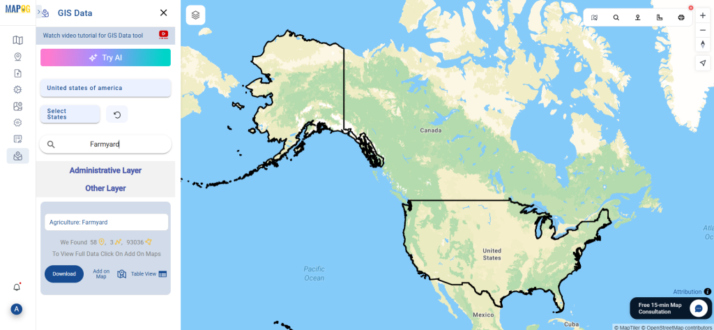
GIS Data by MAPOG simplifies the entire data retrieval process. From a wide collection of over 900+ categorized layers, users can easily locate and Download Farmyard Data from various regions. The platform supports 15+ GIS formats including CSV, SQL, DXF, MIF, TOPOJSON, GPX, and more, making it ideal for multi-purpose usage in agriculture, land-use planning, and environmental assessments.
Download Farmyard Data of any countries
Note:
- All data is provided in GCS datum EPSG:4326 WGS84 CRS (Coordinate Reference System).
- Users need to log in to access and download their preferred data formats.
Step-by-Step Guide to Download Farmyard Data
Step 1: Search for Farmyard Data
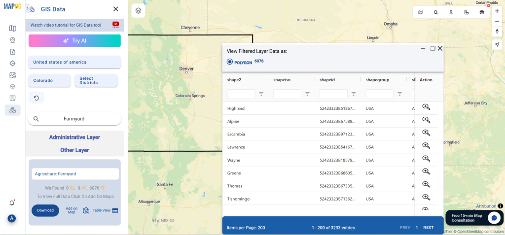
Begin by opening the GIS Data by MAPOG platform and using the search layer bar. Type “Farmyard Data” and browse through the layers provided. Review metadata to confirm if the features are represented as point, line, or polygon geometries.
Step 2: Try the AI Search Tool
Save time with MAPOG’s smart “Try AI” tool. Enter a phrase like “Farmyards near district” and let the AI deliver the most accurate datasets available for your region of interest.
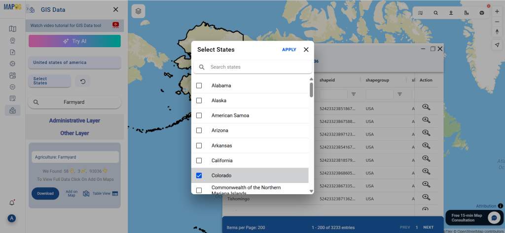
Step 3: Apply State and District Filters
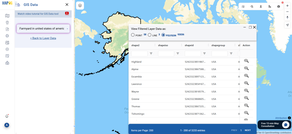
Use the Filter Data option to focus your search. Narrow down datasets by specific states or districts to ensure you’re downloading the most relevant farmyard data for local-scale analysis. This is especially useful when dealing with country-level layers where local filtering becomes essential.
Step 4: Add on Map for Analysis
Click on the “Add on Map” button to visualize your selected farmyard dataset directly on MAPOG’s map interface. This interactive step is perfect for analyzing proximity, spatial distribution, and accessibility of farmyards in relation to roads, water sources, or settlements.
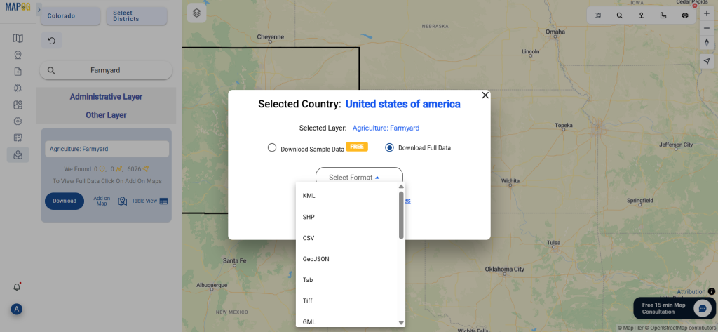
Step 5: Download Farmyard Data
Once you’re confident in your selection, proceed to download. Choose between a free sample or the complete dataset. Then, pick your preferred format—Shapefile, KML, MID, or any of the supported formats—accept the terms, and hit download.
Conclusion
With its simplified workflow and robust format support, GIS Data by MAPOG makes it incredibly efficient to Download Farmyard Data for diverse GIS applications. Whether you’re building an agri-map, conducting a land-use study, or integrating rural data into a GIS dashboard, MAPOG equips you with the tools and datasets needed for in-depth spatial analysis and smarter decision-making.
With MAPOG’s versatile toolkit, you can effortlessly upload vector and upload Excel or CSV data, incorporate existing layers, perform polyline splitting, use the converter for various formats, calculate isochrones, and utilize the Export Tool.
For any questions or further assistance, feel free to reach out to us at support@mapog.com. We’re here to help you make the most of your GIS data.
Download Shapefile for the following:
- World Countries Shapefile
- Australia
- Argentina
- Austria
- Belgium
- Brazil
- Canada
- Denmark
- Fiji
- Finland
- Germany
- Greece
- India
- Indonesia
- Ireland
- Italy
- Japan
- Kenya
- Lebanon
- Madagascar
- Malaysia
- Mexico
- Mongolia
- Netherlands
- New Zealand
- Nigeria
- Papua New Guinea
- Philippines
- Poland
- Russia
- Singapore
- South Africa
- South Korea
- Spain
- Switzerland
- Tunisia
- United Kingdom Shapefile
- United States of America
- Vietnam
- Croatia
- Chile
- Norway
- Maldives
- Bhutan
- Colombia
- Libya
- Comoros
- Hungary
- Laos
- Estonia
- Iraq
- Portugal
- Azerbaijan
- Macedonia
- Romania
- Peru
- Marshall Islands
- Slovenia
- Nauru
- Guatemala
- El Salvador
- Afghanistan
- Cyprus
- Syria
- Slovakia
- Luxembourg
- Jordan
- Armenia
- Haiti And Dominican Republic
- Malta
- Djibouti
- East Timor
- Micronesia
- Morocco
- Liberia
- Kosovo
- Isle Of Man
- Paraguay
- Tokelau
- Palau
- Ile De Clipperton
- Mauritius
- Equatorial Guinea
- Tonga
- Myanmar
- Thailand
- New Caledonia
- Niger
- Nicaragua
- Pakistan
- Nepal
- Seychelles
- Democratic Republic of the Congo
- China
- Kenya
- Kyrgyzstan
- Bosnia Herzegovina
- Burkina Faso
- Canary Island
- Togo
- Israel And Palestine
- Algeria
- Suriname
- Angola
- Cape Verde
- Liechtenstein
- Taiwan
- Turkmenistan
- Tuvalu
- Ivory Coast
- Moldova
- Somalia
- Belize
- Swaziland
- Solomon Islands
- North Korea
- Sao Tome And Principe
- Guyana
- Serbia
- Senegal And Gambia
- Faroe Islands
- Guernsey Jersey
- Monaco
- Tajikistan
- Pitcairn
Disclaimer : The GIS data provided for download in this article was initially sourced from OpenStreetMap (OSM) and further modified to enhance its usability. Please note that the original data is licensed under the Open Database License (ODbL) by the OpenStreetMap contributors. While modifications have been made to improve the data, any use, redistribution, or modification of this data must comply with the ODbL license terms. For more information on the ODbL, please visit OpenStreetMap’s License Page.
Here are some blogs you might be interested in:
- Download Airport data in Shapefile, KML , MIf +15 GIS format – Filter and download
- Download Bank Data in Shapefile, KML, GeoJSON, and More – Filter and Download
- Download Railway data in Shapefile, KML, GeojSON +15 GIS format
- Download Farmland Data in Shapefile, KML, GeoJSON, and More – Filter and Download
- Download Pharmacy Data in Shapefile, KML, GeoJSON, and More – Filter and Download
- Download ATM Data in Shapefile, KML, MID +15 GIS Formats Using GIS Data by MAPOG
- Download Road Data in Shapefile, KML, GeoJSON, and 15+ GIS Form