Download Angola Administrative Boundary Shapefiles – National, Provinces and more

Download GIS data of Angola such as Angola National Boundary, Provinces, Municipalities and more. Download in Shapefile or CSV formats

Are you struggling to find accurate and up-to-date GIS data for your desired country? Worry no more, as MAPOG is here to be your ultimate solution! Our platform offers a comprehensive collection of GIS data covering more than 150 countries. You’ll find an impressive selection of over 150 GIS datasets available for each nation in the MAPOG GIS Data Collection. The hallmark of our GIS data lies in its exceptional accuracy, especially when representing administrative divisions. Moreover, our users can access a diverse range of data pertaining to natural and man-made geographic features, including rivers, roads, railway lines, airport locations, and much more, all meticulously represented in appropriate geometric structures (points, lines, and polygons). Facilitating seamless access to this invaluable data are two essential tools – Download GIS Data and Add GIS Data, thoughtfully integrated into the MAPOG platform. To delve deeper into the functionalities of the Add GIS Data tool, check out our enlightening article – “Add GIS data from IGISMap GIS data collection

With MAPOG’s versatile toolkit, you can effortlessly upload vector and raster filesadd WMS (Web Map Service) layers, upload Excel or CSV data, incorporate existing files, perform polygon splitting and merging, generate new polygon and polyline data, use the converter for various formats, conduct buffer analysiscreate gridstransform points into polygons, calculate isochrones, and utilize the geocoder for precise location information.

We offer an extensive array of data formats, including KML, SHP, CSV, GeoJSON, Tab, SQL, Tiff, GML, KMZ, GPKZ, SQLITE, Dxf, MIF, TOPOJSON, XLSX, GPX, ODS, MID, and GPS, ensuring compatibility and accessibility for various applications and analyses.

Note:

  • All data available are in GCS datum EPSG:4326 WGS84 CRS (Coordinate Reference System).
  • You need to login for downloading the shapefile.

Download Shapefile Data of Angola

Angola is located on the western Atlantic Coast of Southern Africa between Namibia and the Republic of the Congo. It also is bordered by the Democratic Republic of the Congo and Zambia to the east. The country consists of a sparsely watered and somewhat sterile coastal plain extending inland for a distance varying from 50 to 160 km (31 to 99 mi). Slightly inland and parallel to the coast is a belt of hills and mountains and behind those a large plateau. The total land size is 1,246,700 km2 (481,400 sq mi). It has an Exclusive Economic Zone of 518,433 km2 (200,168 sq mi).
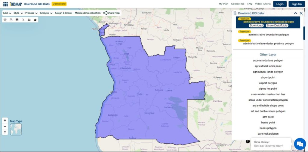
Angola National Boundary

Download Angola National Boundary Shapefile

Download Angola Provinces Shapefile Data

Angola is divided into eighteen provinces, known in Portuguese as províncias:

  • Bengo
  • Caxito
  • Benguela
  • Bié
  • Cabinda
  • Cuando Cubango
  • Cuanza Norte
  • Cuanza Sul
  • Cunene
  • Huambo
  • Huíla
  • Luanda
  • Lunda Norte
  • Lunda Sul
  • Malanje
  • Moxico
  • Namibe
  • Uíge
  • Zaire
Angola Provinces Boundaries

Download Angola Provinces Boundaries Shapefiles

Other GIS Data:

Download Shapefile for the following:

  1. World Countries Shapefile
  2. Australia
  3. Argentina
  4. Austria
  5. Belgium
  6. Brazil
  7. Canada
  8. Denmark
  9. Fiji
  10. Finland
  11. Germany
  12. Greece
  13. India
  14. Indonesia
  15. Ireland
  16. Italy
  17. Japan
  18. Kenya
  19. Lebanon
  20. Madagascar
  21. Malaysia
  22. Mexico
  23. Mongolia
  24. Netherlands
  25. New Zealand
  26. Nigeria
  27. Papua New Guinea
  28. Philippines
  29. Poland
  30. Russia
  31. Singapore
  32. South Africa
  33. South Korea
  34. Spain
  35. Switzerland
  36. Tunisia
  37. United Kingdom Shapefile
  38. United States of America
  39. Vietnam
  40. Norway
  41. Chile
  42. Crotia

Disclaimer : If you find any shapefile data of country provided is in correct do contact us or comment below, so that we will correct the same in our system as well we will try to correct the same in OpenStreetMap.

Download Tonga Administrative Boundary GIS Data – National , Provinces and Districts and more

download-tonga-administrative-boundary-gis-data-national-provinces-and-districts-and-more

It’s fantastic to hear that MAPOG has expanded its GIS data collection to include data for more than 100 new countries, bringing the total coverage to over 150 countries. This is undoubtedly a valuable resource for GIS enthusiasts and professionals around the world. The availability of detailed information on administrative divisions, rivers, roads, and airports can greatly enhance various geospatial projects and analyses.

The option to access the data through tools like “Download GIS Data” and “Add GIS Data” seems convenient and user-friendly. Providing data in different formats such as Shapefile, KML, GeoJSON, and CSV ensures compatibility with a wide range of GIS software and applications, making it easier for users to integrate the data into their workflows.

This article will walk you through downloading administrative-level GIS data for Tonga using the Download GIS Data tool. Experience a seamless geospatial journey with MAPOG as your trusted partner!

Note:

  • All data available are in GCS datum EPSG:4326 WGS84 CRS (Coordinate Reference System).
  • You need to login for downloading the shapefile.

Download Shapefile Data of Tonga

Tonga is an archipelago located in Oceania, situated in the South Pacific Ocean. These islands are categorized into three main groups: Vava’u, Ha’apai, and Tongatapu. They span an 800-kilometre (500-mile)-long north-south line.

Tonga experiences a tropical rainforest climate (Af). It has a distinct warm period from December to April, during which temperatures exceed 32°C (89.6°F). The cooler period lasts from May to November, with temperatures rarely surpassing 27°C (80.6°F). The temperature and rainfall vary across the islands, ranging from 23°C (73.4°F) and 1,700 mm (66.9 in) on Tongatapu in the south to 27°C (80.6°F) and 2,970 mm (116.9 in) on the more northerly islands closer to the Equator.

Tonga National Boundary

Download Tonga National Boundary Shapefile

Download Tonga Provinces Shapefile Data

Tonga is divided into five provinces.

  • Eua
  • Haʻapai
  • Niuas
  • Tongatapu
  • Vavaʻu.
Tonga Provinces Boundaries

Download Tonga Provinces Boundaries Shapefile

Download Tonga Districts Shapefile Data

Tonga is divided into 23 Districts.

  • Kolofo’ou
  • Kolomotu’a
  • Vaini
  • Tatakamotonga
  • Lapaha
  • Nukunuku
  • Kolovai
  • Neiafu
  • Pangaimotu
  • Hahake
  • Leimatu’a
  • Hihifo
  • Motu
  • Lifuka
  • Foa
  • Lulunga
  • Mu’omu’a
  • Ha’ano
  • ‘Uiha
  • ‘Eua Motu’a
  • ‘Eua Fo’ou
  • Niua Toputapu
  • Niua Fo’ou
Tonga Districts Boundaries

Download Tonga Districts Boundaries Shapefile

Other GIS Data:

Download Shapefile for the following:

  1. World Countries Shapefile
  2. Australia
  3. Argentina
  4. Austria
  5. Belgium
  6. Brazil
  7. Canada
  8. Denmark
  9. Fiji
  10. Finland
  11. Germany
  12. Greece
  13. India
  14. Indonesia
  15. Ireland
  16. Italy
  17. Japan
  18. Kenya
  19. Lebanon
  20. Madagascar
  21. Malaysia
  22. Mexico
  23. Mongolia
  24. Netherlands
  25. New Zealand
  26. Nigeria
  27. Papua New Guinea
  28. Philippines
  29. Poland
  30. Russia
  31. Singapore
  32. South Africa
  33. South Korea
  34. Spain
  35. Switzerland
  36. Tunisia
  37. United Kingdom Shapefile
  38. United States of America
  39. Vietnam
  40. Norway
  41. Chile
  42. Croatia
  43. Estonia
  44. Laos
  45. Hungary
  46. Libya
  47. Comoros
  48. Colombia
  49. Bhutan
  50. Maldives
  51. Iraq
  52. Azerbaijan
  53. Portugal

Disclaimer : If you find any shapefile data of country provided is incorrect do contact us or comment below, so that we will correct the same in our system as well we will try to correct the same in OpenStreetMap.

Download Tokelau Administrative Boundary Shapefiles – National , Atolls and More

download-tokelau-administrative-boundary-shapefiles-national-atolls-and-more

It’s fantastic to hear that MAPOG has expanded its GIS data collection to include data for more than 100 new countries, bringing the total coverage to over 150 countries. This is undoubtedly a valuable resource for GIS enthusiasts and professionals around the world. The availability of detailed information on administrative divisions, rivers, roads, and airports can greatly enhance various geospatial projects and analyses.

The option to access the data through tools like “Download GIS Data” and “Add GIS Data” seems convenient and user-friendly. Providing data in different formats such as Shapefile, KML, GeoJSON, and CSV ensures compatibility with a wide range of GIS software and applications, making it easier for users to integrate the data into their workflows.

This article will walk you through downloading administrative-level GIS data for Tokelau using the Download GIS Data tool. Experience a seamless geospatial journey with MAPOG as your trusted partner!

Note:

  • All data available are in GCS datum EPSG:4326 WGS84 CRS (Coordinate Reference System).
  • You need to login for downloading the shapefile.

Download Shapefile Data of Tokelau

Tokelau comprises three atolls in the South Pacific Ocean, situated between longitudes 171° W and 173° W, and latitudes 8° S and 10° S. It is located approximately midway between Hawaii and New Zealand. Spanning less than 200 km, Tokelau stretches from Atafu in the north to Fakaofo in the south. These atolls are positioned around 500 kilometers (311 miles) north of Samoa. The atolls consist of Atafu and Nukunonu, both part of the Duke of Clarence Group, and Fakaofo, formerly known as Bowditch Island.

Tokelau National Boundary

Download Tokelau National Boundary Shapefile

Download Tokelau Atolls Shapefile Data

Tokelau is divided into three Atolls.

  •  Fakaofo 
  • Nukunonu 
  • Atafu
Tokelau Atolls Boundaries

Download Tokelau Atolls Boundaries Shapefile

  1. World Countries Shapefile
  2. Australia
  3. Argentina
  4. Austria
  5. Belgium
  6. Brazil
  7. Canada
  8. Denmark
  9. Fiji
  10. Finland
  11. Germany
  12. Greece
  13. India
  14. Indonesia
  15. Ireland
  16. Italy
  17. Japan
  18. Kenya
  19. Lebanon
  20. Madagascar
  21. Malaysia
  22. Mexico
  23. Mongolia
  24. Netherlands
  25. New Zealand
  26. Nigeria
  27. Papua New Guinea
  28. Philippines
  29. Poland
  30. Russia
  31. Singapore
  32. South Africa
  33. South Korea
  34. Spain
  35. Switzerland
  36. Tunisia
  37. United Kingdom Shapefile
  38. United States of America
  39. Vietnam
  40. Norway
  41. Chile
  42. Croatia
  43. Estonia
  44. Laos
  45. Hungary
  46. Libya
  47. Comoros
  48. Colombia
  49. Bhutan
  50. Maldives
  51. Iraq
  52. Azerbaijan
  53. Portugal

Disclaimer : If you find any shapefile data of country provided is incorrect do contact us or comment below, so that we will correct the same in our system as well we will try to correct the same in OpenStreetMap.

Download Chile Administrative Boundary Shapefiles – Regional State Administrative Agencies, Municipalities & more

That’s fantastic news! GIS enthusiasts will definitely appreciate the availability of GIS data for over 100 new countries. If you’re interested in obtaining shapefiles of the important administrative divisions of Chile, you can find the download links for various formats such as KML, GeoJSON, and CSV on the IGISMAP website. These files will allow you to explore and analyze the geographical and administrative aspects of Chile in your GIS applications. Enjoy exploring the data!

Note:

  • All data available are in GCS datum EPSG:4326 WGS84 CRS (Coordinate Reference System).
  • You need to login for downloading the shapefile.

Download Free Shapefile Data of Chile

Chile is a long, narrow country stretching along South America’s western edge, with more than 6,000km of Pacific Ocean coastline. Santiago, its capital, sits in a valley surrounded by the Andes and Chilean Coast Range mountains. The city’s palm-lined Plaza de Armas contains the neoclassical cathedral and the National History Museum. The massive Parque Metropolitano offers swimming pools, a botanical garden and zoo.

Chile National Boundary

Download Chile National Boundary Shapefile

Once you click on the link, you will be redirected to the gis data of Chile, select the format and tap on download button.

Download Chile Province Shapefile Data

A province is the second-largest administrative division in Chile with 56 in total. The largest administrative division in Chile is that of a region with 16 in total.

Chile Province Boundaries Shapefile

Download Chile Province Boundaries Shapefile

Download Chile Municipalities Shapefile Data

A commune is the smallest administrative subdivision in Chile. It may contain cities, towns, villages, hamlets as well as rural areas. In highly populated areas, such as Santiago, Valparaíso and Concepción, a conurbation may be broken into several communes. In sparsely populated areas, conversely, a commune may cover a substantial rural area together with several settled areas which could range from hamlets to towns or cities.

Chile Municipality Boundaries

Download Chile Municipality Boundaries Shapefile

Other Administrative Boundary Data:

Download Free Shapefile for the following:

  1. World Countries Shapefile
  2. Australia
  3. Argentina
  4. Austria
  5. Belgium
  6. Brazil
  7. Canada
  8. Croatia
  9. Denmark
  10. Fiji
  11. Finland
  12. Germany
  13. Greece
  14. India
  15. Indonesia
  16. Ireland
  17. Italy
  18. Japan
  19. Kenya
  20. Lebanon
  21. Madagascar
  22. Malaysia
  23. Mexico
  24. Mongolia
  25. Netherlands
  26. New Zealand
  27. Nigeria
  28. Papua New Guinea
  29. Philippines
  30. Poland
  31. Russia
  32. Singapore
  33. South Africa
  34. South Korea
  35. Spain
  36. Switzerland
  37. Tunisia
  38. United Kingdom Shapefile
  39. United States of America
  40. Vietnam
  41. Norway
  42. Albania
  43. GCC Sates
  44. Bolivia
  45. Algeria

Disclaimer : If you find any shapefile data of country provided is incorrect do contact us or comment below, so that we will correct the same in our system as well we will try to correct the same in OpenStreetMap.

Convert Shapefile to CSV

Sometimes shapefile becomes bulky to carry from one place to another. As it contains various files as .shp, .prj, .shx, .dbf etc. On the other side CSV contains every detail in one file. So CSV can be considered as a good option when you don’t need to render data on map as polygon or polyline or point. There are various options to create CSV from a shapefile either offline or online.

CSV is comma separated value file which is one of the alternative method for storing spatial data in spreadsheet format. You can also upload the Excel file and convert it into spatial data via QGIS tool. There are also other online tools available which can directly convert the Shapefile to CSV. We will show you how easy and useful is IGISMAP for the conversion process. Following are the methods to convert Shapefile to CSV using IGISMAP Converter tool.

IGISMAP (now MAPOG) to Convert Shapefile to CSV

Go to MapOG Converter Tool Shapefile to CSV, after logging in with your registered email and password. If you are a new user, click the Sign Up button in the Login popup and register to IGISMAP by filling the details.

There are three main steps for using GIS Converter:

  • Upload the data
  • Choose the format to which it should be converted
  • Download the converted file.

Step one is to upload your Shapefile which you want to convert. You can upload the file from your system or select from the Recent Files.

Upload Shapefile

Here we using the KML file of California state boundary.

Step two is to select choose the output format of the converted file, in this case its CSV. You can also set the Coordinate Reference System of your preference. As a default CRS will set to WGS 84 (World) [EPSG:4326]. Click on the Convert File button.

Select CSV as Output Format

Your Shapefile will then get converted to CSV file after a few seconds and will be published in the map canvas. You can download the CSV file of California state boundary by clicking the Download Converted File button.

Download and Publish CSV File

The output CSV file is generated with location information represented in WKT format under the field named ‘WKT’.

You can also choose to style the layer or continue with further conversion process by clicking the Convert Another File button.

Shapefile to CSV conversion – OFF-Line (command line) Tool

For using off-line command in your system you need to install ogr2ogr. There is very simple command to convert shapefile to csv file if you dont want to install a bulky GIS tool like QGIS or ArcGIS.

I am giving a way to install GDAL on ubuntu, while the process is almost similar to install the GDAL tool in Windows, Mac or other Linux system.

For installing GDAL for Ubuntu please follow the given commands.

Shapefile to CSV conversion

After installing you can check the availability of ogr2ogr by typing ogr2ogr on terminal.

After that you can follow the command to convert the shapefile to csv (comma separated value format file)

–> ogr2ogr -f CSV output_file_name.csv input_shp_name.shp -lco GEOMETRY=AS_WKT

The same work can be done in code-igniter or using PHP. For that you need to execute this command in shell_exec() method, which takes the command in string format and returns the output in string.

–>  $shpToCSV=”ogr2ogr -f CSV $out.csv $shp.shp -lco GEOMETRY=AS_WKT”;
–>  shell_exec($shpToCSV);

These statements are written in PHP. $ signifies the variable. Here input and output is taken from user and command is written in double quotes to convert in string. Then it is given to shell_exec() method.

Shapefile to CSV conversion – With QGIS Open source Software

If you don’t need to install any library or run online tools as you already have installed GIS software. You can convert shapefile in CSV using GIS software also. You just need to open the shapefile as vector layer and save it as CSV. For adding the vector layer tyou need to go to Layer->add vector layer and browse the shapefile. After the right click on shapefile title and save it as csv. you can also save some selected part.

You may also look on other Conversion of Files like Shapefile to KML or Shapefile to GeoJSON or GeoJSON to TopoJSON etc.

In this way you can convert shapefile in CSV format. Hope you find tutorial of shapefile to CSV conversion is helpful for you. If you find any problem in converting GIS data in CSV format, do comment below with the problem statement. Also if you know any other tool for converting shapefile, do provide your suggestion in the provided box below.

Exit mobile version