Accessing structured livestock location information is essential for agriculture planning, supply chain analysis, and rural development studies. With GIS Data by MAPOG, you can Download Cattle Farms Data in multiple GIS formats such as Shapefile, KML, MID, and many others, ensuring smooth compatibility with different GIS tools. Cattle farms data generally includes farm locations, spatial distribution, and related attributes, helping users analyze patterns, density, and regional coverage more effectively.
How to Download Cattle Farms Data
MAPOG streamlines the entire process of data access, allowing users to explore extensive GIS layers related to agriculture and livestock. Various formats such as SHP, KML, MID, CSV, GeoJSON, SQL, DXF, MIF, GPX, and TOPOJSON are supported, making it suitable for advanced GIS analysis as well as basic mapping needs.
Download Cattle Farms Data of any countries
Note:
- All datasets are delivered in GCS datum EPSG:4326 (WGS84 Coordinate Reference System).
- User login is required to view and download datasets in preferred formats.
Step-by-Step Guide to Download Cattle Farms Data
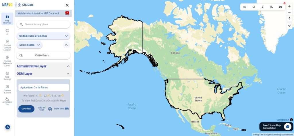
Step 1: Search for Cattle Farms Data
Begin by selecting the required area within the GIS Data by MAPOG interface. Use the layer search option and type “Cattle Farms Data.” The available attributes can be reviewed to understand whether the data is represented as points or polygons.
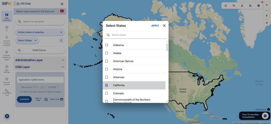
Step 2: Apply Data Filters
To improve accuracy, the Filter Data option can be used to narrow results by state and district. When broader datasets are available, this filtering approach allows deeper data exploration at more granular administrative levels.
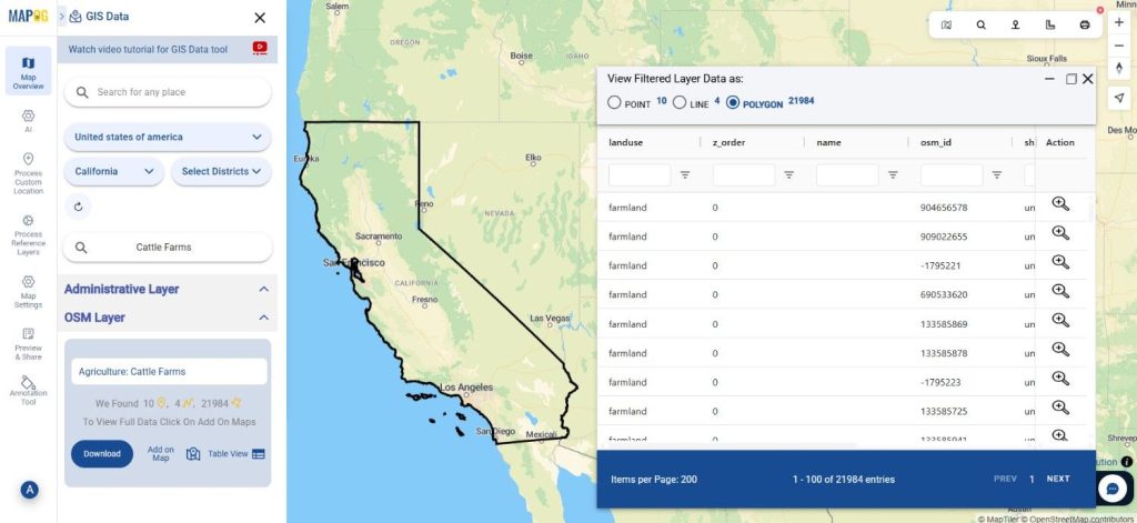
Step 3: Visualize Using “Add on Map”
Before downloading, selected layers can be added directly to the map analysis interface using the “Add on Map” option. This makes it easier to visually assess cattle farm distribution, clustering, and spatial relationships for further analysis.
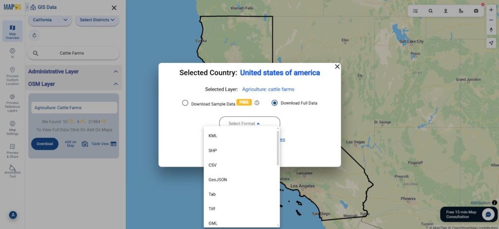
Step 4: Download the Data
Once the dataset meets your requirements, click on the download option. You may choose between sample data or full datasets, select the desired format, accept the terms, and proceed. With this step, users can successfully Download Cattle Farms Data for offline use in any compatible GIS software.
Final Thoughts
GIS Data by MAPOG makes agricultural and livestock-related spatial analysis more accessible and efficient. The ability to Download Cattle Farms Data in multiple GIS formats, combined with smart search, filtering, and visualization tools, ensures flexibility across various use cases. Whether used for research, planning, or analysis, the platform delivers reliable and ready-to-use GIS datasets for informed decision-making.
With MAPOG’s versatile toolkit, you can effortlessly upload vector and upload Excel or CSV data, incorporate existing layers, perform Split polygon by line, use the converter for various formats, calculate isochrones, and utilize the Export Tool.
For any questions or further assistance, feel free to reach out to us at support@mapog.com. We’re here to help you make the most of your GIS data.
Download Shapefile for the following:
- World Countries Shapefile
- Australia
- Argentina
- Austria
- Belgium
- Brazil
- Canada
- Denmark
- Fiji
- Finland
- Germany
- Greece
- India
- Indonesia
- Ireland
- Italy
- Japan
- Kenya
- Lebanon
- Madagascar
- Malaysia
- Mexico
- Mongolia
- Netherlands
- New Zealand
- Nigeria
- Papua New Guinea
- Philippines
- Poland
- Russia
- Singapore
- South Africa
- South Korea
- Spain
- Switzerland
- Tunisia
- United Kingdom Shapefile
- United States of America
- Vietnam
- Croatia
- Chile
- Norway
- Maldives
- Bhutan
- Colombia
- Libya
- Comoros
- Hungary
- Laos
- Estonia
- Iraq
- Portugal
- Azerbaijan
- Macedonia
- Romania
- Peru
- Marshall Islands
- Slovenia
- Nauru
- Guatemala
- El Salvador
- Afghanistan
- Cyprus
- Syria
- Slovakia
- Luxembourg
- Jordan
- Armenia
- Haiti And Dominican Republic
- Malta
- Djibouti
- East Timor
- Micronesia
- Morocco
- Liberia
- Kosovo
- Isle Of Man
- Paraguay
- Tokelau
- Palau
- Ile De Clipperton
- Mauritius
- Equatorial Guinea
- Tonga
- Myanmar
- Thailand
- New Caledonia
- Niger
- Nicaragua
- Pakistan
- Nepal
- Seychelles
- Democratic Republic of the Congo
- China
- Kenya
- Kyrgyzstan
- Bosnia Herzegovina
- Burkina Faso
- Canary Island
- Togo
- Israel And Palestine
- Algeria
- Suriname
- Angola
- Cape Verde
- Liechtenstein
- Taiwan
- Turkmenistan
- Tuvalu
- Ivory Coast
- Moldova
- Somalia
- Belize
- Swaziland
- Solomon Islands
- North Korea
- Sao Tome And Principe
- Guyana
- Serbia
- Senegal And Gambia
- Faroe Islands
- Guernsey Jersey
- Monaco
- Tajikistan
- Pitcairn
Disclaimer : The GIS data provided for download in this article was initially sourced from OpenStreetMap (OSM) and further modified to enhance its usability. Please note that the original data is licensed under the Open Database License (ODbL) by the OpenStreetMap contributors. While modifications have been made to improve the data, any use, redistribution, or modification of this data must comply with the ODbL license terms. For more information on the ODbL, please visit OpenStreetMap’s License Page.
Here are some blogs you might be interested in:
- Download Airport data in Shapefile, KML , MIf +15 GIS format – Filter and download
- Download Bank Data in Shapefile, KML, GeoJSON, and More – Filter and Download
- Download Railway data in Shapefile, KML, GeojSON +15 GIS format
- Download Farmland Data in Shapefile, KML, GeoJSON, and More – Filter and Download
- Download Pharmacy Data in Shapefile, KML, GeoJSON, and More – Filter and Download
- Download ATM Data in Shapefile, KML, MID +15 GIS Formats Using GIS Data by MAPOG
- Download Road Data in Shapefile, KML, GeoJSON, and 15+ GIS Form