Download Palau Administrative Boundary GIS Data – National , Regions and more

download-palau-administrative-boundary-gis-data-national-regions-and-more

It’s fantastic to hear that MAPOG has expanded its GIS data collection to include data for more than 100 new countries, bringing the total coverage to over 150 countries. This is undoubtedly a valuable resource for GIS enthusiasts and professionals around the world. The availability of detailed information on administrative divisions, rivers, roads, and airports can greatly enhance various geospatial projects and analyses.

The option to access the data through tools like “Download GIS Data” and “Add GIS Data” seems convenient and user-friendly. Providing data in different formats such as Shapefile, KML, GeoJSON, and CSV ensures compatibility with a wide range of GIS software and applications, making it easier for users to integrate the data into their workflows.

This article will walk you through downloading administrative-level GIS data for Palau using the Download GIS Data tool. Experience a seamless geospatial journey with MAPOG as your trusted partner!

Note:

  • All data available are in GCS datum EPSG:4326 WGS84 CRS (Coordinate Reference System).
  • You need to login for downloading the shapefile.

Download Shapefile Data of Palau

Palau’s territory is made up of an archipelago in the Pacific Ocean. The most populous islands are Angaur, Babeldaob, Koror, and Peleliu. The latter three are located within the same barrier reef, while Angaur is an oceanic island several kilometers to the south. Approximately two-thirds of the population resides on Koror.

The coral atoll of Kayangel is north of these islands, and the uninhabited Rock Islands (about 200) are to the west of the main island group. A remote group of six islands, known as the Southwest Islands, located some 604 kilometers (375 miles) from the main islands, make up the states of Hatohobei and Sonsorol.

Palau National Boundary shapefile
Palau National Boundary

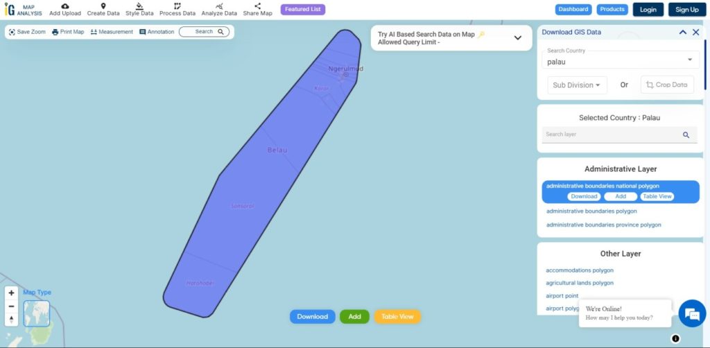
Download Palau National Boundary Shapefile

Download Palau Regions Shapefile Data

Palau is divided in 16 Regions. This Regions are also known as States

Palau Regions Boundaries

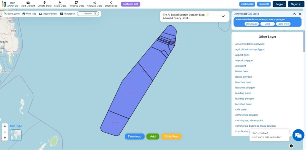
Download Palau Regions Boundaries Shapefile

Other GIS Data:

Download Shapefile for the following:

  1. World Countries Shapefile
  2. Australia
  3. Argentina
  4. Austria
  5. Belgium
  6. Brazil
  7. Canada
  8. Denmark
  9. Fiji
  10. Finland
  11. Germany
  12. Greece
  13. India
  14. Indonesia
  15. Ireland
  16. Italy
  17. Japan
  18. Kenya
  19. Lebanon
  20. Madagascar
  21. Malaysia
  22. Mexico
  23. Mongolia
  24. Netherlands
  25. New Zealand
  26. Nigeria
  27. Papua New Guinea
  28. Philippines
  29. Poland
  30. Russia
  31. Singapore
  32. South Africa
  33. South Korea
  34. Spain
  35. Switzerland
  36. Tunisia
  37. United Kingdom Shapefile
  38. United States of America
  39. Vietnam
  40. Norway
  41. Chile
  42. Croatia
  43. Estonia
  44. Laos
  45. Hungary
  46. Libya
  47. Comoros
  48. Colombia
  49. Bhutan
  50. Maldives
  51. Iraq
  52. Azerbaijan
  53. Portugal

Disclaimer : If you find any shapefile data of country provided is incorrect do contact us or comment below, so that we will correct the same in our system as well we will try to correct the same in OpenStreetMap

Upload your shapefile and create a buffer layer

Consider that you are working in the urban planning sector. Higher authorities in the sector have decided to develop the surroundings of the bank area. Your senior has assigned you a project to create a buffer so that later the architect can design the area separately.

When you are working with spatial operations and analysis, GIS is the best method to find a solution to any task. A geographic information system (GIS) is a system that creates, manages, analyzes, and maps all types of data.

IGISMap provides you with all the facilities for spatial operations and analysis without any difficulty. It is easy to use, and it saves your time.

How to upload file in IGISMap

An upload vector file is a GIS tool in IGISMap. This tool helps you to upload a file of your requirement.

Click on https://map.igismap.com/upload-vector-files and open the Upload Vector file tool

Upload shapefile and create a buffer layer
Upload Vector File Tool

Browse Data

In the select layer click on Browse to find the relevant data from the device.

Upload shapefile and create a buffer layer
Browse Data

Select File

Now select the appropriate file, then click on open.

Upload shapefile and create a buffer layer
Select file

Upload File

Since we have selected the file, now click on upload to add data in IGISMap.

Upload shapefile and create a buffer layer
Upload File

Map Tools

After uploading the shapefile click on Tools, to access other GIS tools. Here you can do bubble style, icon style, category style or label feature, etc. shown in image below.

Upload shapefile and create a buffer layer
Map Tools

In Map Tools, Open Buffer analysis tool. You can also try other tools like converter, split polygon, merge polygon, point to polygon, etc

Upload shapefile and create a buffer layer
Open Buffer Analysis tool

Buffer Analysis Tool

The buffer Analysis tool of IGISMap is a powerful GIS tool. This tool helps you to create a zone of your requirement which is also called Buffer.

Upload shapefile and create a buffer layer

Select Layer

In the select layer click on the Select option, then from the drop-down Manu select the GIS Data, after that click on Next

Upload shapefile and create a buffer layer
Select Data

Create Buffer

In create buffer, Select draw a polygon option. Draw a polygon that covers the input shapefile.

create buffer
Draw a Polygon

Enter the value in meters for buffer map, then click on submit.

buffer map
Draw a polygon

Share Your Map

You can directly share the map by clicking on Share Map.

share your map
Share Map

After filing up Map Operation, Click on the next button.

Map Operation

You can share your map as per your requirement.

Share Map

You can also use the link to share the relevant data.

Use the link to share the data

In the above steps, you have learned about sharing a map. If you want to embed the map on your website then that is also possible with this tool.