KMZ to SHP using MAPOG, you can transform gis data, making it easier to analyze, share, and integrate into various GIS applications.
In this guide, we’ll walk you through how to efficiently convert your KMZ files to SHP using the powerful Converter Tool in MAPOG. Whether you’re a beginner or an experienced user, Converting KMZ to SHP with MAPOG, this tutorial will help you understand the process in easy steps.
Key Concept of Converting files
The Converter Tool is a feature in MAPOG Map Analysis that helps you change your data from one format to another. It’s like magic! You give it your data in one form, and it transforms it into another form that you need for your analysis. Additionally, with GIS Data, you can download data in any format, making it versatile and adaptable for various applications.
Online KMZ to SHP GIS Converter
Now, let’s walk through the simple steps of using the Converter Tool to Converting KMZ to SHP with MAPOG.
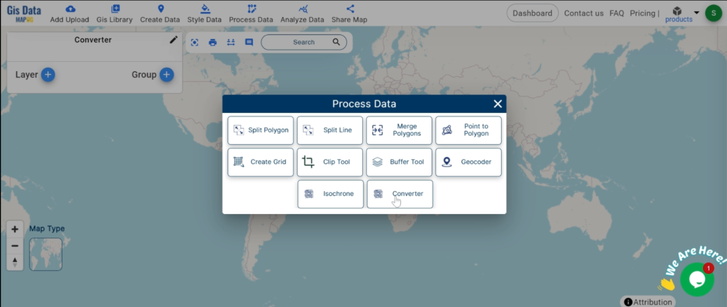
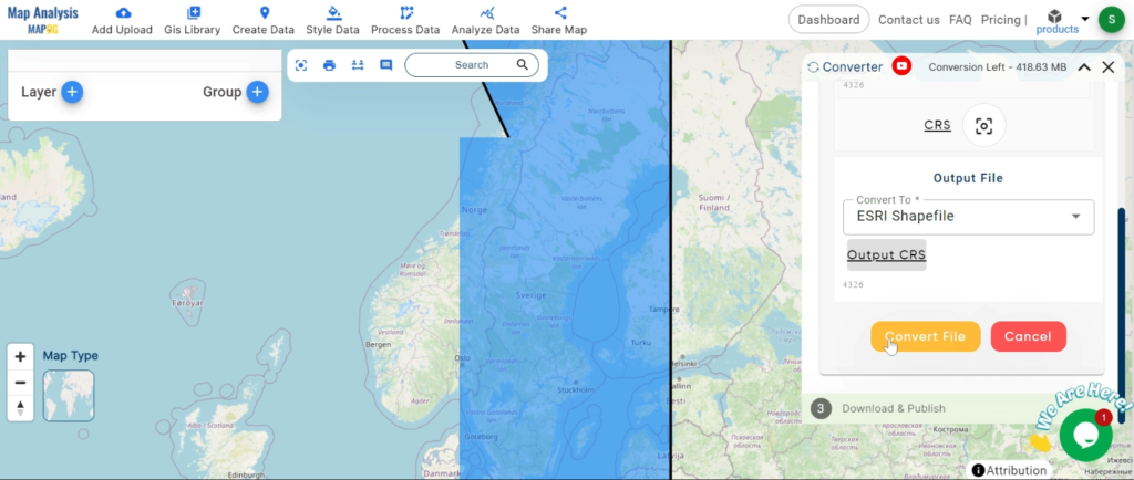
Step 1: Upload the Data
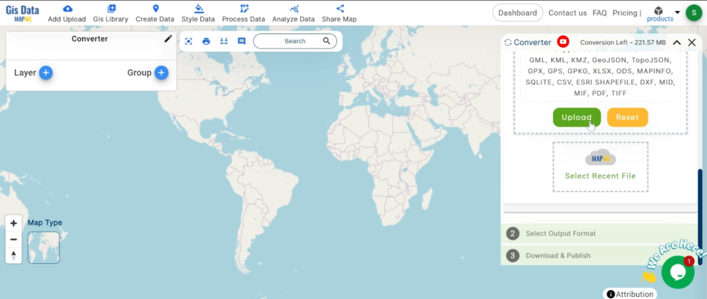
1. Click on the “Process Data” menu and choose the “Converter Tool” option.
2.Upload your KMZ file. This is your starting point where you provide the data that needs conversion.
Step 2: Select the Format for Conversion
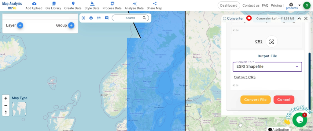
1.Choose the output file format as SHP. The tool offers various formats, but for this guide, we are focusing on converting to SHP.
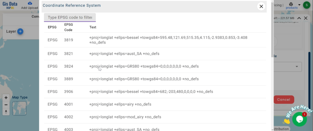
2.You can also set the CRS at this stage.
Step 3: Run the Conversion
Click ‘Convert’ and let the tool work its magic. The Converter Tool processes your data, transforming it from KMZ to SHP format.
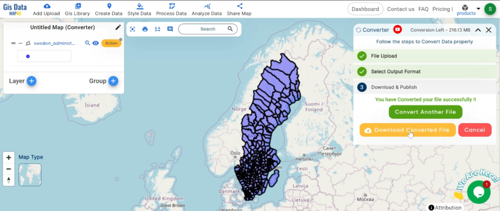
Step 4: Review and Download
Finally, review your converted SHP data to ensure it looks right. Once satisfied, download the converted file. This step is crucial to verify that the conversion has been successful and the data integrity is maintained.
And there you have it! You’ve successfully used the Converter Tool in MAPOG Map Analysis to convert your KMZ files to SHP. Now you can easily convert your data for all your analysis needs. This feature simplifies the process of handling different data formats, making your workflow more efficient and effective.
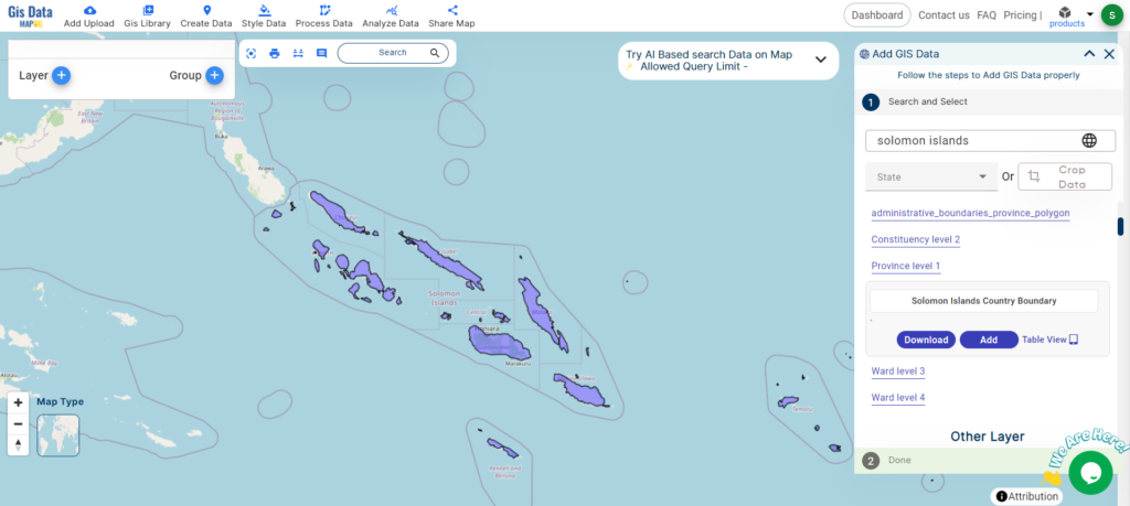
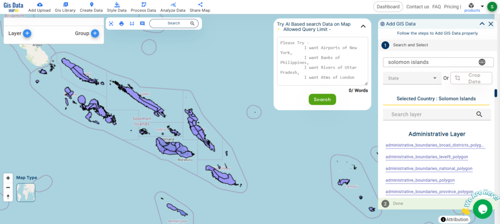
Access and download Solomon Islands administrative boundary GIS data, including national, provinces, and constituencies
Unleash the power of GIS mapping in the Solomon Islands with MAPOG! Delve into a comprehensive collection of GIS data, including administrative boundaries encompassing the nation’s many islands and atolls. Effortlessly explore Solomon Islands’ unique geography with MAPOG. Discover a wealth of datasets featuring boundaries, rivers, and even transportation infrastructure like airports. MAPOG’s user-friendly tools empower you to download GIS data in various formats, including Shapefile, KML, GeoJSON, and CSV. Dive into the fascinating world of Solomon Islands GIS data with confidence – choose MAPOG!
All data available are in GCS datum EPSG:4326 WGS84 CRS (Coordinate Reference System).
You need to login for downloading the shapefile.
Download Shapefile Data of Solomon Islands
The Solomon Islands, an island nation in Melanesia (part of Oceania), consists of over 900 islands northeast of Australia. Neighboring countries include Papua New Guinea to the west, Fiji to the east, and Vanuatu to the southeast. With Honiara as its capital on the largest island, Guadalcanal, the country boasts a population of over 734,000 and a total area of roughly 28,896 square kilometers. Interestingly, the Solomon Islands archipelago extends beyond the nation’s borders, also encompassing the Autonomous Region of Bougainville (part of Papua New Guinea) but excluding the Santa Cruz Islands.
After successfully logging in with a legitimate email address, select the country you want to work with. Next, choose the specific layer you need and click on the download option. Once that’s done, pick the desired format to acquire the essential GIS data. Before proceeding with the data download, make sure to review the data table for any relevant information.
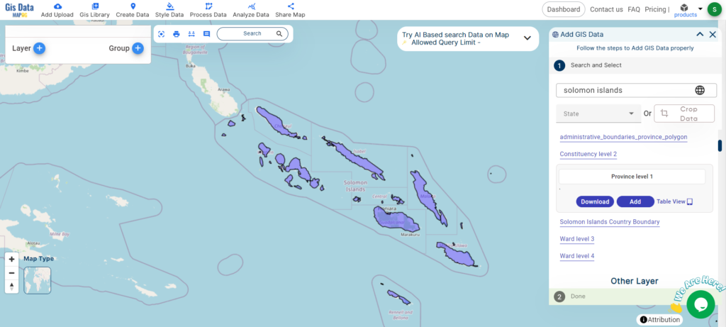
Download Solomon Islands Provinces Shapefile Data
Solomon Islands is divided into nine provinces. The national capital, Honiara, on the island of Guadalcanal, is separately governed as the country’s Capital Territory.
Disclaimer : If you find any shapefile data of country provided is incorrect do contact us or comment below, so that we will correct the same in our system as well we will try to correct the same in openstreetmap.
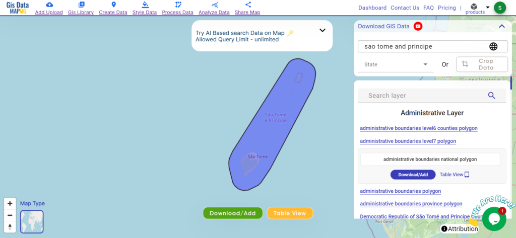
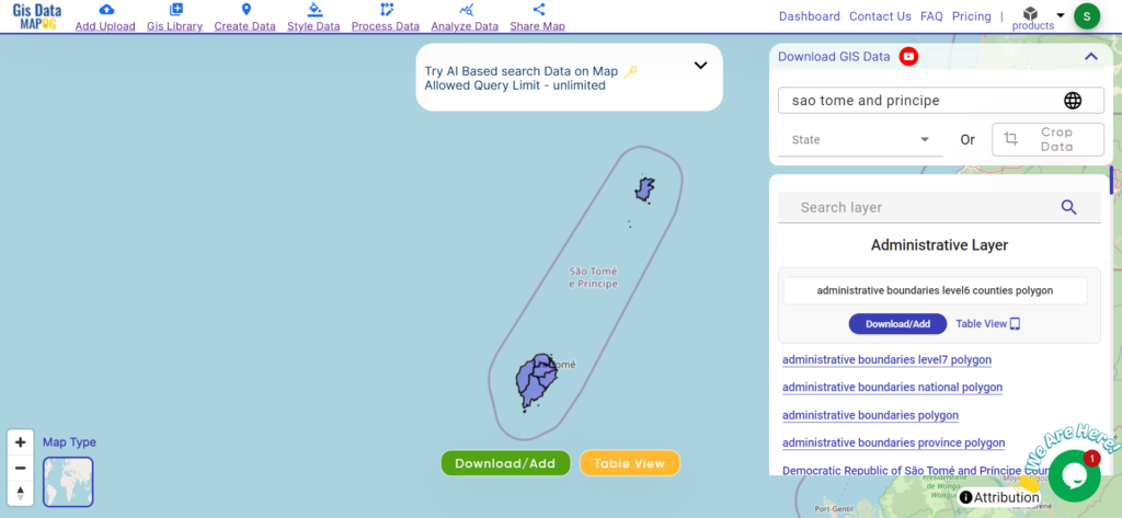
Unlock Sao Tome and Principe’s GIS data: national boundaries, provincial, and district divisions in various formats with MAPOG.
Unlock a world of geospatial insights with MAPOG, your gateway to Download Sao Tome And Principe Administrative Boundary GIS Data. Dive into a treasure trove of datasets covering national, administrative divisions, and more.
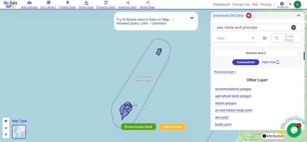
Navigating and Download Sao Tome And Principe Administrative Boundary GIS Data is seamless with MAPOG. Access over 150 meticulously curated datasets detailing administrative boundaries and geographic features such as coastlines, roads, and conservation areas. Our platform offers intuitive tools for effortless exploration: Download GIS Data and Add GIS Data. With the Download GIS Data tool, choose from a variety of formats like Shapefile, KML, GeoJSON, or CSV to obtain the precise data you need. Need guidance on using the Add GIS Data tool? Consult our comprehensive guide for step-by-step instructions. Let MAPOG be your trusted companion on an enriching geospatial journey through the breathtaking landscapes of Sao Tome and Principe.
Our platform supports an extensive range of data formats, including KML, SHP, CSV, GeoJSON, Tab, SQL, Tiff, GML, KMZ, GPKZ, SQLITE, Dxf, MIF, TOPOJSON, XLSX, GPX, ODS, MID, and GPS, ensuring seamless compatibility and accessibility across different analyses.
Note:
all data provided by MAPOG are in GCS datum EPSG:4326 WGS84 CRS (Coordinate Reference System).
access to shapefile downloads requires logging in to the platform.
Download Data of Sao Tome and Principe
Sao Tome and Principe, nestled in the Gulf of Guinea, offer a captivating blend of natural beauty and cultural heritage. Known for their lush rainforests, pristine beaches, and colonial architecture, these islands are a paradise for nature lovers and adventurers.
Explore Sao Tome and Principe’s provincial divisions, each encapsulating unique cultural and geographical features. Delve into the administrative boundaries and geographic features of these provinces to gain a deeper understanding of their diversity and importance.
Discover the district boundaries of Sao Tome and Principe, fundamental units of governance and essential for regional development efforts. Delve into the administrative boundaries and geographic features of these districts to gain insights into their significance and diversity.
Disclaimer : If you find any shapefile data of country provided is incorrect do contact us or comment below, so that we will correct the same in our system as well we will try to correct the same in openstreetmap.
Explore geography of China seamlessly with MAPOG. Access a diverse range of datasets, including boundaries, rivers, vegetation, and airports. Take advantage of user-friendly tools like Download GIS Data, providing formats such as Shapefile, KML, GeoJSON, and CSV. Delve into China GIS Data confidently with MAPOG.
We offer an extensive array of data formats, including KML, SHP, CSV, GeoJSON, Tab, SQL, Tiff, GML, KMZ, GPKZ, SQLITE, Dxf, MIF, TOPOJSON, XLSX, GPX, ODS, MID, and GPS, ensuring compatibility and accessibility for various applications and analyses.
Note:
All data available are in GCS datum EPSG:4326 WGS84 CRS (Coordinate Reference System).
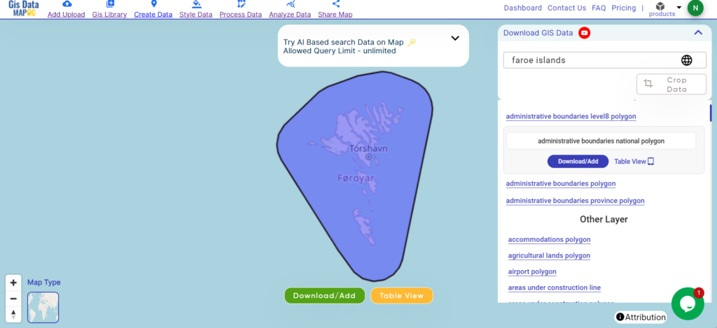
Nestled in the North Atlantic Ocean, the Faroe Islands boast rugged cliffs, verdant valleys, and dramatic fjords across its 1,400-square-kilometer expanse. This autonomous territory of Denmark comprises 18 volcanic islands, with Torshavn as its capital, renowned for its colorful houses lining the harbor. Despite its small size, the Faroes captivate visitors with their pristine landscapes and rich Norse heritage.
After successfully logging in with a legitimate email address, select the country you want to work with. Next, choose the specific layer you need and click on the download option. Once that’s done, pick the desired format to acquire the essential GIS data. Before proceeding with the data download, make sure to review the data table for any relevant information.
Disclaimer: If you find any shapefile data of country provided is incorrect do contact us or comment below, so that we will correct the same in our system as well we will try to correct the same in OpenStreetMap.
Explore geography of China seamlessly with MAPOG. Access a diverse range of datasets, including boundaries, rivers, vegetation, and airports. Take advantage of user-friendly tools like Download GIS Data, providing formats such as Shapefile, KML, GeoJSON, and CSV. Delve into China GIS Data confidently with MAPOG.
We offer an extensive array of data formats, including KML, SHP, CSV, GeoJSON, Tab, SQL, Tiff, GML, KMZ, GPKZ, SQLITE, Dxf, MIF, TOPOJSON, XLSX, GPX, ODS, MID, and GPS, ensuring compatibility and accessibility for various applications and analyses.
Note:
All data available are in GCS datum EPSG:4326 WGS84 CRS (Coordinate Reference System).
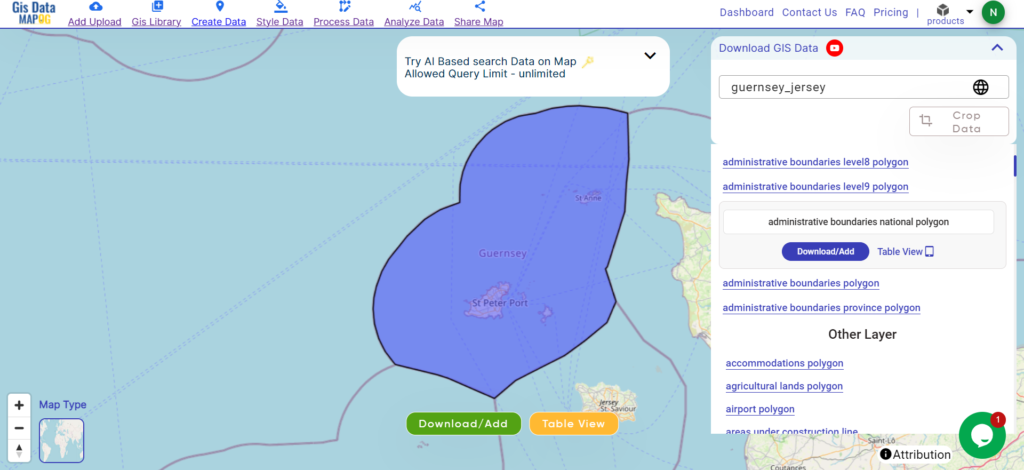
Guernsey and Jersey, nestled in the English Channel, are picturesque islands boasting a rich tapestry of history and culture. With a combined area of approximately 78 square kilometers, these charming destinations offer breathtaking coastlines and quaint countryside. St. Peter Port serves as the capital of Guernsey, while St. Helier holds the same distinction for Jersey, each exuding its own unique charm amidst stunning natural landscapes.
After successfully logging in with a legitimate email address, select the country you want to work with. Next, choose the specific layer you need and click on the download option. Once that’s done, pick the desired format to acquire the essential GIS data. Before proceeding with the data download, make sure to review the data table for any relevant information.
Disclaimer: If you find any shapefile data of country provided is incorrect do contact us or comment below, so that we will correct the same in our system as well we will try to correct the same in OpenStreetMap.
Access and download Sudan administrative boundary GIS data, including national, states, districts and more
Sudan’s vast landscapes beckon you to explore with MAPOG! Delve into a treasure chest of GIS data, revealing the intricate details of administrative boundaries. Navigate the lifeblood of the Nile River and its tributaries. Trace the veins of transportation that crisscross the nation – the roads, and the vital air hubs – its airports. Effortlessly download this wealth of Sudanese GIS data in formats like Shapefile, KML, GeoJSON, and CSV using our user-friendly tools. Empower your analysis of Sudan’s geography – choose MAPOG for all your Sudanese GIS data needs!
We offer an extensive array of data formats, including KML, SHP, CSV, GeoJSON, Tab, SQL, Tiff, GML, KMZ, GPKZ, SQLITE, Dxf, MIF, TOPOJSON, XLSX, GPX, ODS, MID, and GPS, ensuring compatibility and accessibility for various applications and analyses.
Note:
All data available are in GCS datum EPSG:4326 WGS84 CRS (Coordinate Reference System).
You need to login for downloading the shapefile.
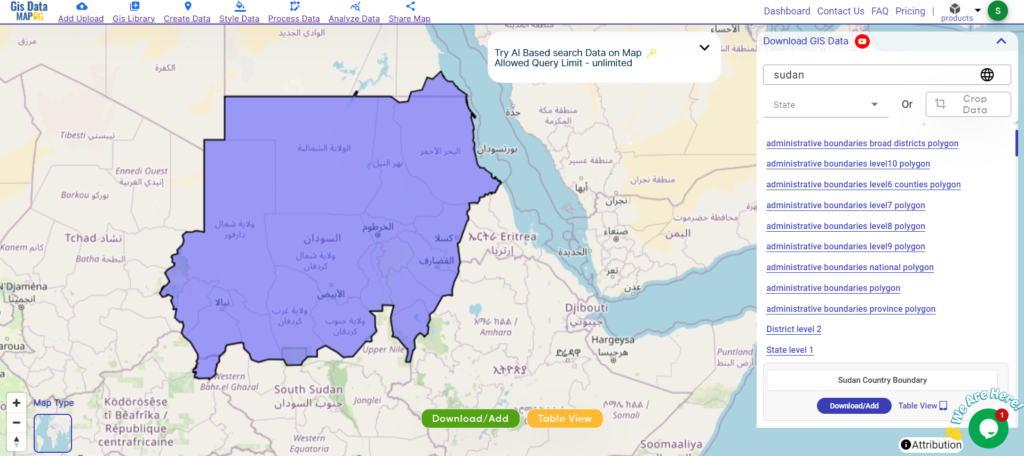
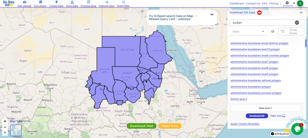
Download Shapefile Data of Sudan
Sudan is a country located in Northeast Africa. It borders eight other countries: Chad to the west, Central African Republic to the southwest, Egypt to the north, Eritrea and Ethiopia to the northeast, Libya to the northwest, and South Sudan to the south. The Red Sea lies to the east of Sudan.
With a population of 45.7 million, Sudan is the third largest country by area in Africa and the Arab League. Khartoum is the capital and most populous city in Sudan.
After successfully logging in with a legitimate email address, select the country you want to work with. Next, choose the specific layer you need and click on the download option. Once that’s done, pick the desired format to acquire the essential GIS data. Before proceeding with the data download, make sure to review the data table for any relevant information.
Download Sudan States Shapefile Data
Sudan is divided into 18 states, known as “wilayat” in Arabic.
Disclaimer : If you find any shapefile data of country provided is incorrect do contact us or comment below, so that we will correct the same in our system as well we will try to correct the same in openstreetmap.
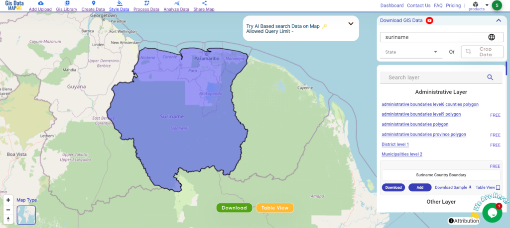
Access and download Suriname administrative boundary GIS data, including national and districts, for comprehensive geographic analysis and mapping.
Unleash the hidden depths of Suriname with MAPOG! Delve into a treasure trove of GIS data, unlocking the intricate details of its administrative regions. Chart the courses of Suriname’s mighty rivers and their winding tributaries. Map your exploration across the country’s vital transportation network – navigate the intricate web of roads and take flight with data on Suriname’s essential air gateways, its airports. Download this wealth of Suriname GIS data with ease in formats like Shapefile, KML, GeoJSON, and CSV using our user-friendly tools. Empower your analysis of Suriname’s geography – choose MAPOG for all your Suriname GIS data needs!.
We offer an extensive array of data formats, including KML, SHP, CSV, GeoJSON, Tab, SQL, Tiff, GML, KMZ, GPKZ, SQLITE, Dxf, MIF, TOPOJSON, XLSX, GPX, ODS, MID, and GPS, ensuring compatibility and accessibility for various applications and analyses.
Note:
All data available are in GCS datum EPSG:4326 WGS84 CRS (Coordinate Reference System).
You need to login for downloading the shapefile.
Download Shapefile Data of Suriname
Suriname, officially the Republic of Suriname is a country in northern South America, sometimes considered part of the Caribbean and the West Indies. Located slightly north of the equator, over 90% of its territory is covered by rainforests, giving it the highest proportion of forest cover in the world. Suriname is bordered by the Atlantic Ocean to the north, French Guiana to the east, Guyana to the west, and Brazil to the south. It is the smallest country in South America by both population and area, with approximately 612,985 inhabitants and an area of about 163,820 square kilometers (63,251 square miles). The capital and largest city is Paramaribo, which is home to roughly half the population.
After successfully logging in with a legitimate email address, select the country you want to work with. Next, choose the specific layer you need and click on the download option. Once that’s done, pick the desired format to acquire the essential GIS data. Before proceeding with the data download, make sure to review the data table for any relevant information.
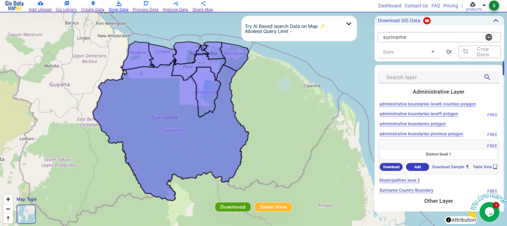
Download Suriname Districts Shapefile Data
Suriname is divided into ten administrative districts, each with its own unique characteristics and attractions.
Suriname is divided into districts, which are further subdivided into municipalities. However, the term “municipality” is not commonly used in Suriname’s administrative divisions. Instead, each district is divided into several resorts (ressorten).
Disclaimer : If you find any shapefile data of country provided is incorrect do contact us or comment below, so that we will correct the same in our system as well we will try to correct the same in openstreetmap.
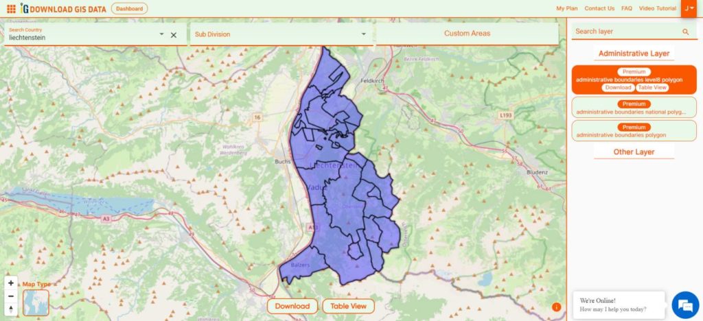
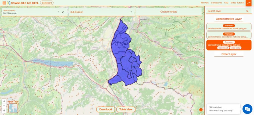
Unlock the potential of mapping! MAPOG introduces a unique opportunity: download Liechtenstein’s administrative boundary GIS data, encompassing national, municipalities, and more. Elevate your mapping projects with these comprehensive GIS datasets. Seize the opportunity for enriched exploration and mapping experiences!
0Hello GIS enthusiasts! Get ready for some exciting news from MAPOG. We’re thrilled to introduce our carefully curated GIS data designed specifically for Liechtenstein. This data will give you detailed geographical insights and complete administrative boundaries. Whether you’re working on local or national mapping projects, our top-notch resource can take your work to the next level. You can easily access this data in various formats like ESRI Shapefile, KML, GeoJSON, and CSV, making integration a breeze. Don’t miss out on this fantastic opportunity to enhance your mapping endeavors with the latest Liechtenstein GIS data. Start exploring today!
We offer an extensive array of data formats, including KML, SHP, CSV, GeoJSON, Tab, SQL, Tiff, GML, KMZ, GPKZ, SQLITE, Dxf, MIF, TOPOJSON, XLSX, GPX, ODS, MID, and GPS, ensuring compatibility and accessibility for various applications and analyses.
Note:
All data available are in GCS datum EPSG:4326 WGS84 CRS (Coordinate Reference System).
You need to login for downloading the shapefile.
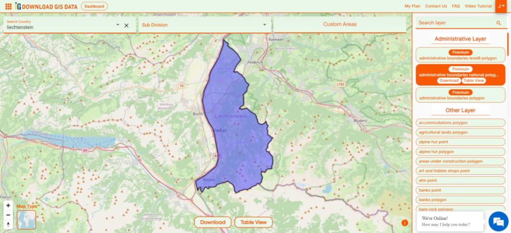
Download Shapefile Data of Liechtenstein
Liechtenstein, known as Fürstentum Liechtenstein in German, is a nation nestled within the Alpine region, positioned between Austria and Switzerland. This doubly landlocked microstate is recognized for its German-speaking populace. Despite its small size, Liechtenstein holds the distinction of being the sixth smallest country globally. Governed by a semi-constitutional monarchy, the country is led by its reigning prince.
After successfully logging in with a legitimate email address, select the country you want to work with. Next, choose the specific layer you need and click on the download option. Once that’s done, pick the desired format to acquire the essential GIS data. Before proceeding with the data download, make sure to review the data table for any relevant information.
Download Liechtenstein Municipality Shapefile Data
Liechtenstein is organized into eleven municipalities, with many of them comprising a single town. Among these, five municipalities are situated in the Unterland (lower country) electoral district, while the remaining six are located in the Oberland (upper country).
Disclaimer : If you find any shapefile data of country provided is incorrect do contact us or comment below, so that we will correct the same in our system as well we will try to correct the same in openstreetmap.
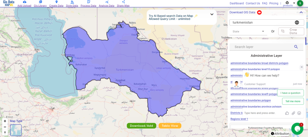
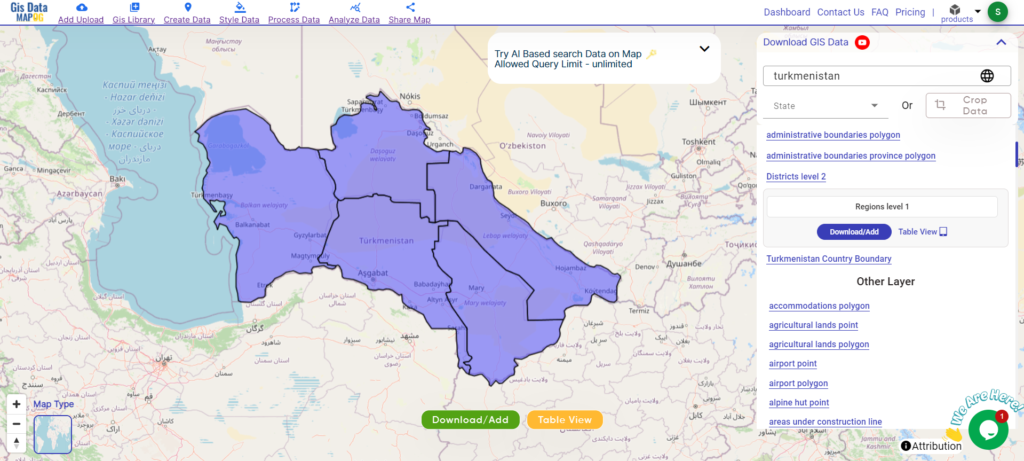
Access and download Turkmenistan administrative boundary GIS data, including national, regions, and districts, for comprehensive geographic analysis and mapping.
Unleash the rich tapestry of Turkmenistan with MAPOG! Delve into a treasure trove of GIS data, unlocking the intricate details of its administrative regions. Chart the courses of Turkmenistan’s mighty rivers and their winding tributaries. Map your exploration across the country’s vital transportation network – navigate the intricate web of roads and take flight with data on Turkmenistan’s essential air gateways, its airports. Download this wealth of Turkmenistan GIS data with ease in formats like Shapefile, KML, GeoJSON, and CSV using our user-friendly tools. Empower your analysis of Turkmenistan’s geography – choose MAPOG for all your Turkmenistan GIS data needs!
We offer an extensive array of data formats, including KML, SHP, CSV, GeoJSON, Tab, SQL, Tiff, GML, KMZ, GPKZ, SQLITE, Dxf, MIF, TOPOJSON, XLSX, GPX, ODS, MID, and GPS, ensuring compatibility and accessibility for various applications and analyses.
Note:
All data available are in GCS datum EPSG:4326 WGS84 CRS (Coordinate Reference System).
You need to login for downloading the shapefile.
Download Shapefile Data of Turkmenistan
Turkmenistan is a country in Central Asia bordered by Kazakhstan to the northwest, Uzbekistan to the north and east, Afghanistan to the southeast, Iran to the south and southwest, and the Caspian Sea to the west. Ashgabat is the capital and largest city. It is one of the six independent Turkic states. With a population of 6.5 million, Turkmenistan is the 35th most populous country in Asia and the least populous of the Central Asian republics, making it one of the most sparsely populated nations on the Asian continent.
After successfully logging in with a legitimate email address, select the country you want to work with. Next, choose the specific layer you need and click on the download option. Once that’s done, pick the desired format to acquire the essential GIS data. Before proceeding with the data download, make sure to review the data table for any relevant information.
Download Turkmenistan Regions Shapefile Data
Turkmenistan is divided into five regions (welaýatlar) and one capital city with the status of an administrative region. Here are the regions and the capital city:
Disclaimer : If you find any shapefile data of country provided is incorrect do contact us or comment below, so that we will correct the same in our system as well we will try to correct the same in openstreetmap.
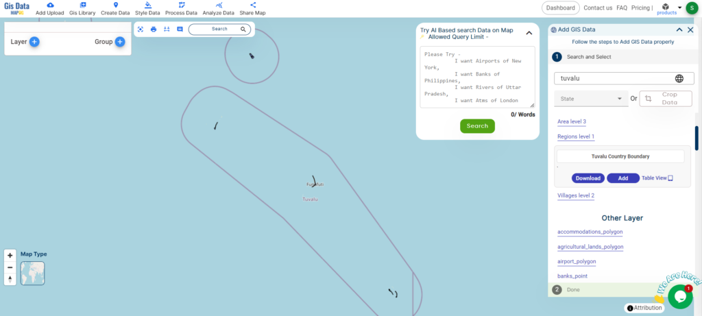
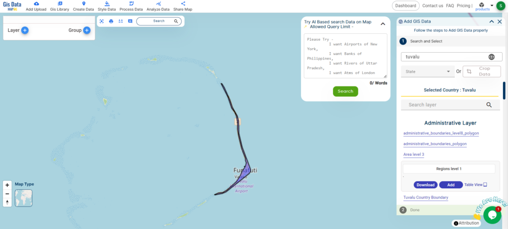
Access and download Tuvalu administrative boundary GIS data, including national, regions, and villages, for detailed geographic analysis and mapping.
Unleash the captivating charm of Tuvalu with MAPOG! Dive deep into a treasure trove of GIS data, unveiling the intricate details of its island havens. Trace the courses of Tuvalu’s turquoise lagoons and map your exploration across its coral reefs teeming with life. Navigate the turquoise expanse with data on Tuvalu’s vital transportation network – chart a course across the intricate web of island connections and explore the skies with information on Tuvalu’s essential air gateways. Download this wealth of Tuvalu GIS data with ease in formats like Shapefile, KML, GeoJSON, and CSV using our user-friendly tools. Empower your exploration of Tuvalu’s unique geography – choose MAPOG for all your Tuvalu GIS data needs!
We offer an extensive array of data formats, including KML, SHP, CSV, GeoJSON, Tab, SQL, Tiff, GML, KMZ, GPKZ, SQLITE, Dxf, MIF, TOPOJSON, XLSX, GPX, ODS, MID, and GPS, ensuring compatibility and accessibility for various applications and analyses.
Note:
All data available are in GCS datum EPSG:4326 WGS84 CRS (Coordinate Reference System).
You need to login for downloading the shapefile.
Download Shapefile Data of Tuvalu
Tuvalu, formerly known as the Ellice Islands, is an island country in the Polynesian subregion of Oceania in the Pacific Ocean. It is situated about midway between Hawaii and Australia. Tuvalu lies east-northeast of the Santa Cruz Islands (part of the Solomon Islands), northeast of Vanuatu, southeast of Nauru, south of Kiribati, west of Tokelau, northwest of Samoa and Wallis and Futuna, and north of Fiji.
After successfully logging in with a legitimate email address, select the country you want to work with. Next, choose the specific layer you need and click on the download option. Once that’s done, pick the desired format to acquire the essential GIS data. Before proceeding with the data download, make sure to review the data table for any relevant information.
Download Tuvalu Regions Shapefile Data
Tuvalu is divided into nine islands, which function as administrative regions. These islands are:
Disclaimer : If you find any shapefile data of country provided is incorrect do contact us or comment below, so that we will correct the same in our system as well we will try to correct the same in openstreetmap.
We use cookies to ensure that we give you the best experience on our website. If you continue to use this site we will assume that you are happy with it.Ok