Adding Multiple Map Layers – Hide Show layer using Leaflet js

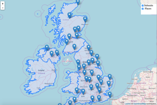
This article is about how you can make visible and invisible your layer with the help of checkbox on any base map. The base layer used here is OSM (Open street map), which is open source freely available map. With layers at the same time you can open up multiple data at once and make … Continue reading “Adding Multiple Map Layers – Hide Show layer using Leaflet js”

Create beautiful dynamic Legend map – Leafletjs TopoJson

In this article we are going to add legends to choropleth map with topojson Data using leaflet. Legends are the element of map that provides information about map with the help of symbols. Here symbol can be colour, shapes, figures etc. The choropleth map gives information using colours. Lets play around with : Create beautiful Legend … Continue reading “Create beautiful dynamic Legend map – Leafletjs TopoJson”

Create Heat map showing average household income – leaflet js GIS

First of all we must know what heat map is? A Heat Map is a way of representing the density or intensity value of point data by assigning a colour gradient to a raster where the cell colour is based on clustering of points or an intensity value. In this article i.e to Create Heat map … Continue reading “Create Heat map showing average household income – leaflet js GIS”

Read Parse Render TopoJSON file – Leaflet js

This article shows how to render topojson file data on OSM map with the help of d3 and Leaflet javascript library in the browser. Leaflet js is an open source small library to create interactive map. You may look over Getting Started with Leaflet js. TopoJSON is one of the GIS data structure which stores … Continue reading “Read Parse Render TopoJSON file – Leaflet js”

Add different base map layers using leaflet js

Leaflet is  small open source Javascript library to create a customised mapping solution. Leaflet plugin supports many types of map layer. In this article we have map layers as Google map, Open street map, Stamen map, Here map and Bing map layer. What is plugin? Plugin is software that is installed onto a program, enabling … Continue reading “Add different base map layers using leaflet js”

Convert Shapefile to TopoJSON

ESRI shapefile are the binary vector data storage format for storing the location, shape, and attributes of geographic features. It is stored as a set of related files and contains one feature class. Whereas TopoJSON (topological geospatial data) is an extension of GeoJSON that encodes topology. The necessity of conversion is to reduce the size … Continue reading “Convert Shapefile to TopoJSON”

Convert GeoJSON to TopoJSON – GIS

Convert GeoJSON to TopoJSON. GeoJSON is an open standard format designed for representing simple geographical features, along with their non-spatial attributes, based on JavaScript Object Notation. The need of conversion is to reduce the size of data, so that rendering of data on browser can be made faster. TopoJSON (topological geospatial data) is an extension … Continue reading “Convert GeoJSON to TopoJSON – GIS”

Geographic Information System (GIS) for Telecom Sector Industry

Earlier the basic necessities were limited to food, clothes and Shelter. As we all know , that, everything changes with the time, so has had happened with the basic necessities of an individual. Basic necessities of an Individual has also changed over a period of time. Telecom is an add on to the basic necessities … Continue reading “Geographic Information System (GIS) for Telecom Sector Industry”

Geographic Information System (GIS) for Hospital Industry – How, When and Uses

GIS (Geographic Information System) for Hospital Industry. ‘Health is wealth’, this quote is the truth. One can have everything with wealth but not health. One has to do so much to keep the health with them. But at some point of time everyone need an additional support to keep the health on track. That support … Continue reading “Geographic Information System (GIS) for Hospital Industry – How, When and Uses”

GIS for Agriculture – When and Why

Agriculture plays a very vital role in everyone’s life. For few agriculture is not the only way of having food in their plate, rather a source of income. We get food from agriculture, one can not imagine his life without agriculture. Agriculture brings food in our plate, hence the agriculture needs to be proper care … Continue reading “GIS for Agriculture – When and Why”