Publish Style Raster Dataset On GeoServer

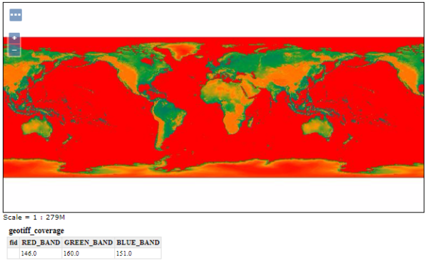
Publish Style Raster Dataset On GeoServer. Do you have raster data and want to host the data on geoserver and create a proper map with styling according to dataset? Well GeoServer gives you a direct and simple method to create a styled map. Before implementing steps to publish and sytle raster dataset on geoserver you … Continue reading “Publish Style Raster Dataset On GeoServer”

Install Geoserver – Windows OS – Step by Step

GeoServer is an open source server for sharing geospatial data in both vector and raster format. It is designed to host major data sources, which can easily render on maps. Download stable version of GeoServer to Install: Google out http://geoserver.org/ link. Hit the Download tab and install the stable version of geoserver. In this tutorial … Continue reading “Install Geoserver – Windows OS – Step by Step”

Shp to SQL – Convert Shapefile to postgersql file

Shapefile shp can be converted in pgsql file using shp2pgsql command line tool. Sometimes you have a shapefile and want to upload the same in postgresql database, you can directly use shp2pgsql command and upload shapefile to postgis. While there might be possibilites that you would not be having access to your production server to … Continue reading “Shp to SQL – Convert Shapefile to postgersql file”

Shp to MIF – Convert Shapefile to MapInfo Interchange Format

Many people uses MapServer as their Server, so they might need to store shape file as MIF (Map Info File) file on server. The OGR Simple Features Library allows MapServer users to display several types of vector data files in their native formats. For example, MapInfo Mid/Mif and TAB data can be seen on MapServer … Continue reading “Shp to MIF – Convert Shapefile to MapInfo Interchange Format”

SHP to XLSX – Convert Shapefile to Excel

Sometimes we just need to see attribute details not geometry. So instead of carrying heavy shape files we can convert them in XLSX format. XLSX file contains on attribute detail or can say non spatial data. XLSX files are light in weight. Along with shp to xlsx convert you may also check for shp to … Continue reading “SHP to XLSX – Convert Shapefile to Excel”

Shp to ODS – Convert Shapefile to Open Document Spreadsheet

Shape file to ODS (Open Document Spreadsheet) conversion is required when you only need non spatial information i.e. only attribute information. This conversion need ogr2ogr utility. Or you may also you any other tool to convert shp to ods easily. Convert SHP to ODS using MapOG Tool for hassle free conversion What is ODS (Open Document … Continue reading “Shp to ODS – Convert Shapefile to Open Document Spreadsheet”

SHP to GML – Convert Shapefile to Geography Markup Language

Shape file shp to GML conversion is required when you carry data from one place to another. Shapefiles are heavy as compared with GML (Geography Markup Language). On the other hand we can say that GML makes you able to do many of the same things that you would do with heavyweight desktop GIS files. … Continue reading “SHP to GML – Convert Shapefile to Geography Markup Language”

SHP to GPX / GPS – Convert Shapefile to Global Positioning System

Shapefile shp can be converted into GPS ( Global Positioning System) using ogr2ogr utility. The GPS data is best option when routes and tracks are required in XML format. Here we will check how to convert shapefile shp to GPX / GPS. Convert Shp to GPX – Using IGIS Map Tool Go to MapOG Conversion Tool . … Continue reading “SHP to GPX / GPS – Convert Shapefile to Global Positioning System”

Shp to KML KMZ – Convert Shapefile to Keyhole Markup Language

Shapefile Shp to KML KMZ Convert. Many times you may want to render your shapefile directly in Google Map and check the view. Or you may want to convert the shapefile shp to KML so that it becomes easy to program with Google Map API. You can also check the file with Google Earth by … Continue reading “Shp to KML KMZ – Convert Shapefile to Keyhole Markup Language”

Convert Shapefile to GeoPackage – GPKG

GeoPackage is an open, standards-based, platform-independent, portable, self-describing, compact format for transferring geospatial information. Whereas shapefile is collection of geometry with attribute detail. Here in this article, we will check how to convert Shapefile to GeoPackage or GPKG GIS format. Online Tool To Convert Shapefile to GeoPackage file The GeoPackage Encoding Standard describes a set … Continue reading “Convert Shapefile to GeoPackage – GPKG”