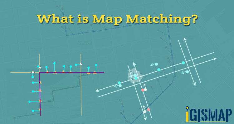
Locate DP Junctions, Ports, Fiber Cables, Connected Houses – GIS Telecom

In Telecommunication ‘tele’ comes from Greek means far off and ‘communication’ means exchange of information using some medium. Location information is elemental for telecommunication and GIS in Telecom is widely accepted. Geographical Information System tools manages and analyzes the location of dp junction, available ports, fiber cables lines on the map that increases efficiency of the system. Locate DP … Continue reading “Locate DP Junctions, Ports, Fiber Cables, Connected Houses – GIS Telecom”

QGIS Tutorial: Unsupervised classification using KMeansClassification

Unsupervised classification is based on software analysis. It uses computer techniques for determining the pixels which are related and sort them into classes. In this post we doing unsupervised classification using KMeansClassification in QGIS. For supervised classification check earlier articles. For Beginners check – QGIS Tutorial Unsupervised classification using  KMeansClassification in QGIS Add a raster … Continue reading “QGIS Tutorial: Unsupervised classification using KMeansClassification”

QGIS Tutorial – Vector Analysis – Create New Projection

Projection is a method to represent 3D data into 2D. It plays a important role in GIS. A map projection is termed as Coordinate Reference System (CRS) and QGIS allows users to define custom CRS. So in this article QGIS Tutorial – Vector Analysis – Create New Projection we will get familiar with creating your own CRS … Continue reading “QGIS Tutorial – Vector Analysis – Create New Projection”

What is bearing angle and calculate between two Points

In geometry angles are measured regardless of direction or orientation as in trigonometry we measure angle by rotating anti clockwise. Here x-axis is (0) zero degree and y-axis is at 90 degree. So in this article we get familiar with What is bearing and calculate angle between two points. In GIS bearing angle is used … Continue reading “What is bearing angle and calculate between two Points”

Create a free tour or video in Google Earth Pro

Google Earth a google developed free platform that allows us to view  high resolution satellite image of Earth, Moon, Mars and sky. Through Google Earth you can explore the world with satellite imagery. In the previous article we explained how to  Download Satellite image for free. A 3D representation with 360 degree view. For GIS … Continue reading “Create a free tour or video in Google Earth Pro”

Create and Share Custom Maps – Add on Website, Social Sites Share

Howdy Guys, in these days and age of open source society where people no spun out depends on told information maps play a vital role. In this article we are showing a feature of IGIS Map Tool –  Create and Share Custom Maps – Add on Website, Social Sites Share. You can share maps for business … Continue reading “Create and Share Custom Maps – Add on Website, Social Sites Share”

QGIS Tutorial – Quantum GIS Guide

QGIS is one of the most common open source application used by GIS analyst, Geographers, Civil Engineers and many other professionals. If you are new in the field of Geographic Information System (GIS)  you should consider learning this application, as it will help you to solve many complex problems, analyze area, create reports etc. with … Continue reading “QGIS Tutorial – Quantum GIS Guide”

QGIS 3.4.4 tutorial : Creating, Editing and Mapping in GIS

Hello Folks if you are looking for QGIS 3.4.4 tutorial then you are at right place. Here in this article QGIS 3.4.4 tutorial : Creating, Editing and Mapping in GIS you will grasp to create new shapefile. QGIS 3.4.4 tutorial : Creating, Editing and Mapping in GIS Before creating new map layer go to browser panal. … Continue reading “QGIS 3.4.4 tutorial : Creating, Editing and Mapping in GIS”

Quick Embed Customized Map on website

Quick Embed Customized Map on website is a easiest way of adding a map on your website. And make your website interactive by embedding map on it. Maps are more attractive then numbers and words. It is also beneficial for  your business. Quick Embed Customized Map on website  – Using Igis Map Tool Benefits of Embed … Continue reading “Quick Embed Customized Map on website”