Merge more than two Shapefile in QGIS. Do you want to merge two or more than two Shapefile? Do all the Shapefile are of same shape type i.e the Shapefile which can be merged with each other should have an identical shape, i.e either “Point”, “Line” or “Polygon”? Do Shapefile all 3 files i.e .shx, .shp and .dbf are available? Then let us move to QGIS (Quantum GIS), an Open source Geographic information System Software. If not installed in your system, one of the way to install QGIS, with OSGeo4W provides or either you can install QGIS with standalone software. Let us move to Merge more than two Shapefile:
You may also find how to merge two or more than two features in shapefile. Also you may read more tutorials in QGIS.
Merge more than two Shapefile in QGIS
1.) Take and copy all Shapefiles to a common folder which you want to merge.
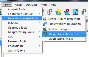
2.) Open up QGIS desktop and select the following from the menu :
- Vector -> Data Management tools -> merge shapefile to one, which will open up new window “Merge Shapefiles”, as shown below.
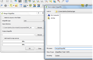
3.) Now select the browse input directory to the folder you created which include all Shapefile that you need to copy. Also browse the Output directory for getting the new merged Shapefile, and name the output file, as shown below:
4.) Press Ok. It will process your all shapefile and merge it to one. Finished.
- Note: New .dbf file will contain sum of column of two shapfefile minus common column.
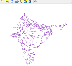
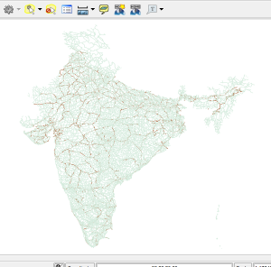
Here you can see the output of two merged Shapefile of Road and Rail Route of India.
1.) Road Shapefile of india
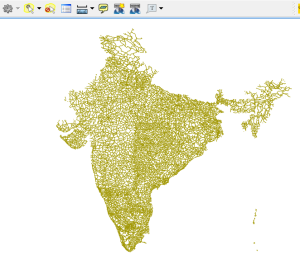
2.) Rail Route Shapefile
3.) Final Output : Merged Shapefile :
Hope this helps you to merge two or more shapefile with the help of QGIS tool. You can also find QGIS operation to convert Shapefile to GeoJSON, convert kml to Shapefile and Shapefile to KML. If you find any problem on implementing the above steps do comment below. Your suggestions are always welcome as comment.
Thank you for the information. I have successfully completed the above steps and merged two shapefiles of same shape. But Can we merge two shapefile of different shapes?
Thank you for this article but I am experiencing a problem. I merge the two files but when I go check the table it only shows the lines of one of the shapefile. The columns are ok though. But the lines for example: I have 19 lines in one shapefile and 9 in another. Each shapefile as a column named “name” that is imported automatically from the GPS to QGIS. In the name column on one file it goes from 001 to 020 (note that it starts on 0 so that is why it has 19 lines) and on the other file it goes from 021 to 030. Now the problem is: I merge the files and the final file only show or lines from 001 to 020 or 021 to 030, and after all, it adds like 50 useless lines with no data. Do you know what is happening? I want to have a final file with lines from 001 to 030 and the exact same columns. Thanks in advance.
Hey Alexandre,
Welcome. I am not getting the exact problem what happening. But still you can solve the problem by deleting those extra line or edit the attribute table. Here is the tutorial for the same http://www.igismap.com/digitization-in-qgis-exploring-tools-for-digitizing/. I hope this may help you.
I can’t find Vector -> Data Management tools -> merge shapefile in my QGIS 2.18.5. My options are: Split vector layers, Join attributes by location, Define current projection, Create current projection, Merge vector layers.
Similar, in 3.2.3 the following are the only available options:
Merge Vector Layers, Reproject Layer, Create Spatial Index, Join Attributes by Location, Split Vector Layer
after editing .shp file in qgis
i did i open layer properties in that i change symbol then i press save default
after merged all files those symbol effects not visible
Hi
I went through the process but I had the error occurred while executing python code