In this post we are going to discuss the procedures for KML to Shapefile conversion. KML is the file extensions used in Google applications, specifically Google Earth and Google Maps. Shapefile is a geospatial vector data format for geographic information system (GIS) software. It is developed and regulated by ESRI as a mostly open specification for data interoperability among ESRI and other GIS software products.
Conversion of GIS data like KML to Shapefile can be done easily using
MAPOG Online KML To Shapefile Converter tool.
IGISMAP to Convert KML to Shapefile
For KML to Shapefile conversion go to MAPOG Converter Tool, after logging in with your registered email and password. If you are a new user, click the Sign Up button in the Login popup and register to IGISMAP by filling the details.
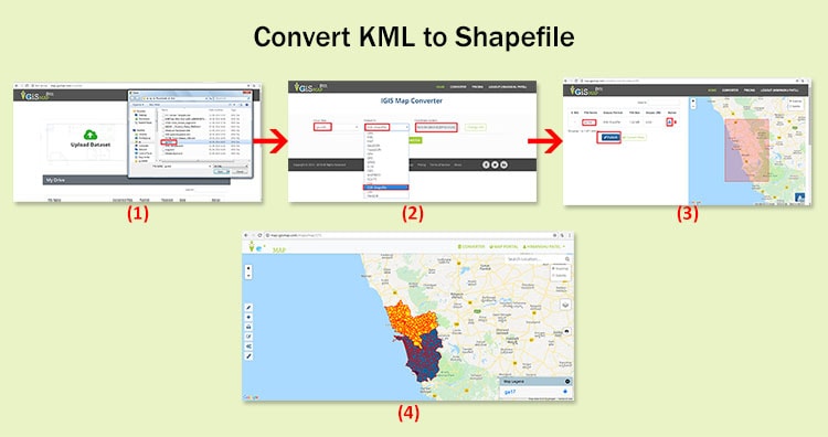
There are three main steps for using GIS Converter:
- Upload the data
- Choose the format to which it should be converted
- Download the converted file.
Step one is to upload your KML file which you want to convert. You can upload your file from system or select from the Recent Files.

Here we have uploaded the KML file of New York state in USA.
Step two is to select choose the output format of the converted file, in this case its Shapefile. You can also set the Coordinate Reference System of your preference. As a default CRS will set to WGS 84 (World) [EPSG:4326]. Click on the Convert File.

Your KML file will then get converted to Shapefile file after a few seconds and will be available for downloading.

You can also choose to style the layer or continue with further conversion process by clicking the Convert Another File button.
The Converted File can also be downloaded from the Converted Files section of the dashboard.
Converted Files section from the dashboard contains the list of the details of all the conversion done in your account, providing both input and output data available for download their corresponding formats.
Furthermore:
If you face any problem during implementing this tutorial, please let us know by dropping a mail at support@igismap.com. Feel free to comment in the below comment box.