Historical monuments are valuable landmarks that reflect the cultural, architectural, and historical significance of a region. If you’re looking to Download Monuments Data for mapping, heritage conservation, tourism planning, research, or GIS analysis, GIS Data by MAPOG provides an efficient way to access well-structured datasets. The platform supports multiple GIS formats, including Shapefile, KML, MID, GeoJSON, and many others, making the data compatible with leading GIS software.
Understanding the Download Process
GIS Data by MAPOG allows users to explore monument datasets from an extensive collection of over 200 countries and 900+ GIS layers. The platform is designed to simplify data discovery while offering multiple export formats such as SHP, KML, CSV, GeoJSON, SQL, DXF, MIF, TOPOJSON, GPX, and more. As a result, users can quickly locate and download the datasets they need for spatial analysis and visualization.
Download Monuments Data of Any Region
Note:
- All datasets are provided in the GCS Datum EPSG:4326 (WGS84 Coordinate Reference System).
- Users must sign in to access and download data in their preferred GIS format.
Step-by-Step Guide to Download Monuments Data
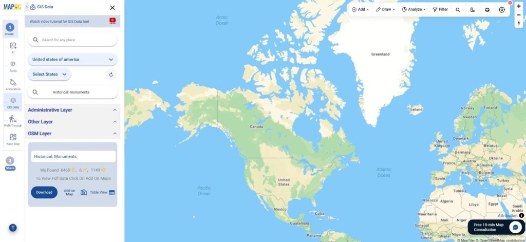
Step 1: Search for Monuments Data
Begin by selecting your required region in the GIS Data by MAPOG platform. Next, use the Search Layer option and enter “Monuments Data“ Review the available dataset and its attributes to identify whether the features are available as points, polygons, or other geometry types.
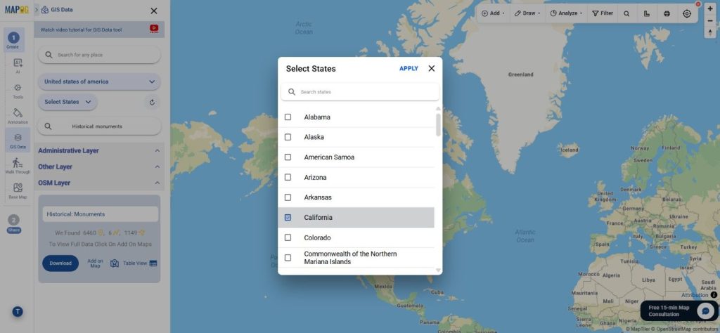
Step 2: Filter the Dataset
Use the Filter Data option to narrow down the results according to your requirements. Large datasets can be filtered by state and district, allowing you to locate specific monument records without manually searching through the complete dataset. This makes the information more focused and easier to work with.
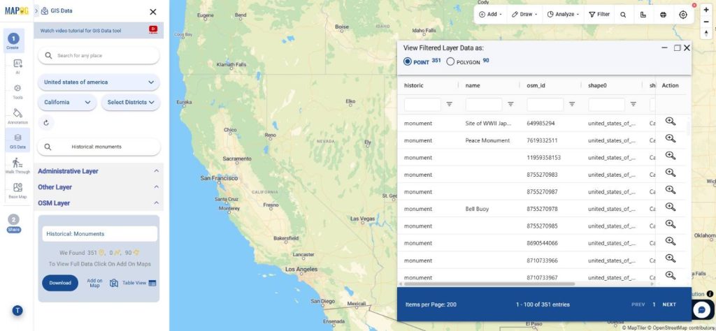
Step 3: Add the Dataset to the Map
Before downloading, click Add on Map to load the selected monument layer into the MAPOG Map Analysis interface. This allows you to visualize the dataset alongside other GIS layers, inspect spatial relationships, and perform additional analysis before exporting the data.
Step 4: Download the Dataset
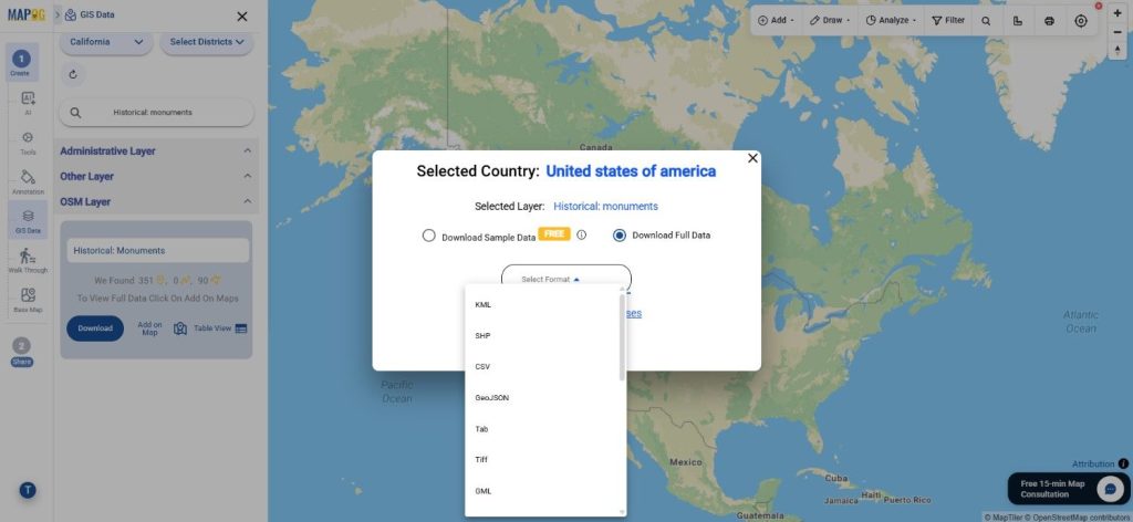
Once you’ve verified the dataset, click Download Data. You can choose to download either a sample dataset or the complete version. Select your preferred format, such as Shapefile, KML, MID, GeoJSON, or any of the other supported GIS formats, accept the terms, and complete the download process.
Final Thoughts
Whether you’re working on heritage documentation, tourism mapping, urban planning, academic research, or spatial analysis, Download Monuments Data quickly and efficiently with GIS Data by MAPOG. With support for more than 15 GIS formats, advanced filtering options, AI-powered search, and seamless integration with the Map Analysis interface, the platform offers a practical solution for accessing and working with monument datasets for a wide range of GIS projects.
With MAPOG’s versatile toolkit, you can effortlessly upload vectors and upload Excel or CSV data, incorporate existing layers, perform polygon splitting, use the converter for various formats, calculate isochrones, and utilize the Export Tool.
For any questions or further assistance, feel free to reach out to us at support@mapog.com. We’re here to help you make the most of your GIS data.
Download Shapefile for the following:
- World Countries Shapefile
- Australia
- Argentina
- Austria
- Belgium
- Brazil
- Canada
- Denmark
- Fiji
- Finland
- Germany
- Greece
- India
- Indonesia
- Ireland
- Italy
- Japan
- Kenya
- Lebanon
- Madagascar
- Malaysia
- Mexico
- Mongolia
- Netherlands
- New Zealand
- Nigeria
- Papua New Guinea
- Philippines
- Poland
- Russia
- Singapore
- South Africa
- South Korea
- Spain
- Switzerland
- Tunisia
- United Kingdom Shapefile
- United States of America
- Vietnam
- Croatia
- Chile
- Norway
- Maldives
- Bhutan
- Colombia
- Libya
- Comoros
- Hungary
- Laos
- Estonia
- Iraq
- Portugal
- Azerbaijan
- Macedonia
- Romania
- Peru
- Marshall Islands
- Slovenia
- Nauru
- Guatemala
- El Salvador
- Afghanistan
- Cyprus
- Syria
- Slovakia
- Luxembourg
- Jordan
- Armenia
- Haiti And Dominican Republic
- Malta
- Djibouti
- East Timor
- Micronesia
- Morocco
- Liberia
- Kosovo
- Isle Of Man
- Paraguay
- Tokelau
- Palau
- Ile De Clipperton
- Mauritius
- Equatorial Guinea
- Tonga
- Myanmar
- Thailand
- New Caledonia
- Niger
- Nicaragua
- Pakistan
- Nepal
- Seychelles
- Democratic Republic of the Congo
- China
- Kenya
- Kyrgyzstan
- Bosnia Herzegovina
- Burkina Faso
- Canary Island
- Togo
- Israel And Palestine
- Algeria
- Suriname
- Angola
- Cape Verde
- Liechtenstein
- Taiwan
- Turkmenistan
- Tuvalu
- Ivory Coast
- Moldova
- Somalia
- Belize
- Swaziland
- Solomon Islands
- North Korea
- Sao Tome And Principe
- Guyana
- Serbia
- Senegal And Gambia
- Faroe Islands
- Guernsey Jersey
- Monaco
- Tajikistan
- Pitcairn
Disclaimer : The GIS data provided for download in this article was initially sourced from OpenStreetMap (OSM) and further modified to enhance its usability. Please note that the original data is licensed under the Open Database License (ODbL) by the OpenStreetMap contributors. While modifications have been made to improve the data, any use, redistribution, or modification of this data must comply with the ODbL license terms. For more information on the ODbL, please visit OpenStreetMap’s License Page.
Here are some blogs you might be interested in:
- Download Airport data in Shapefile, KML , MIf +15 GIS format – Filter and download
- Download Bank Data in Shapefile, KML, GeoJSON, and More – Filter and Download
- Download Railway data in Shapefile, KML, GeojSON +15 GIS format
- Download Farmland Data in Shapefile, KML, GeoJSON, and More – Filter and Download
- Download Pharmacy Data in Shapefile, KML, GeoJSON, and More – Filter and Download
- Download ATM Data in Shapefile, KML, MID +15 GIS Formats Using GIS Data by MAPOG
- Download Road Data in Shapefile, KML, GeoJSON, and 15+ GIS Form
Leave a Reply