Searching for accurate kindergarten location data for your next GIS project? Download Kindergarten Data easily using GIS Data by MAPOG — a user-centric platform designed to deliver detailed spatial datasets in a wide range of formats, including Shapefile, KML, MID, GeoJSON, and more. Whether you’re mapping early childhood education access, planning infrastructure, or conducting urban studies, MAPOG offers structured and up-to-date data to support comprehensive spatial analysis.
How to Download Kindergarten Data
GIS Data by MAPOG simplifies the process of accessing education facility datasets by offering a clean, guided interface. With over 900+ categorized layers and support for 15+ GIS formats such as SHP, KML, MID, GeoJSON, CSV, DXF, SQL, GPX, and TOPOJSON, this platform suits both beginners and GIS professionals alike.
Download Kindergarten Data of any countries
Note:
- All data is provided in GCS datum EPSG:4326 WGS84 CRS (Coordinate Reference System).
- Users need to log in to access and download their preferred data formats.
Step-by-Step Guide to Download Kindergarten Data
Step 1: Search for Kindergarten Data
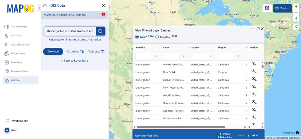
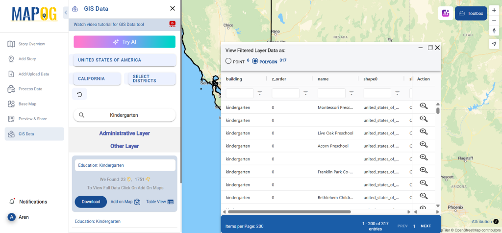
Begin by logging in to GIS Data by MAPOG. Use the layer search tool and type in “Kindergarten Data.” Review the dataset details to check whether it’s available as point or polygon features, depending on your analytical needs.
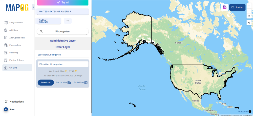
Step 2: Use the AI Search Tool
Don’t want to search manually? MAPOG’s built-in “Try AI” tool can do the work for you. Just enter a phrase like “Kindergartens near me” or “Kindergarten facilities,” and the AI will fetch matching layers instantly. This smart feature accelerates the process and enhances precision.
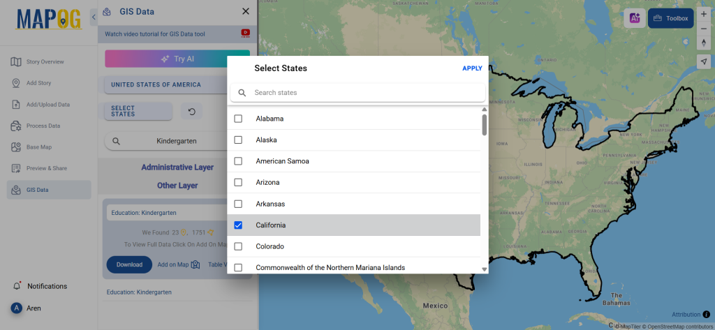
Step 3: Refine with Filters
Narrow down your data using the Filter Data option. You can filter kindergartens by state or district, allowing for hyper-localized datasets that are perfect for in-depth spatial evaluations.
Step 4: Visualize with ‘Add on Map’
Before downloading, you can visualize your selected data using the Add on Map feature. This lets you overlay kindergarten locations onto the interactive map, enabling you to evaluate patterns, clusters, and geographic spread in real-time.
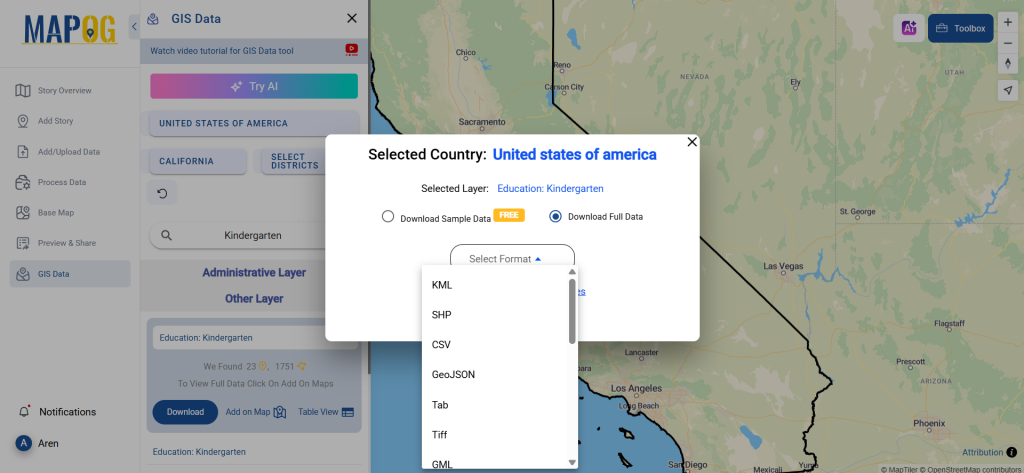
Step 5: Download Kindergarten Data
Once you’re happy with your selection, hit the “Download Data” button. Choose between a sample or full dataset, pick your preferred format — whether it’s Shapefile, KML, MID, or others — and proceed with the download. Accept the terms, and you’re ready to use the data in your preferred GIS tool.
Final Thoughts
With its intuitive interface and rich format options, GIS Data by MAPOG makes it remarkably easy to download Kindergarten Data for any kind of spatial study. Whether you are an academic, policymaker, or GIS professional, this platform equips you with the data you need for accurate, actionable insights. Explore the layers, filter precisely, and visualize effectively — all in one place. Don’t wait — Download Kindergarten Data today and take your spatial analysis to the next level.
With MAPOG’s versatile toolkit, you can effortlessly upload vector and upload Excel or CSV data, incorporate existing layers, perform polyline splitting, use the converter for various formats, calculate isochrones, and utilize the Export Tool.
For any questions or further assistance, feel free to reach out to us at support@mapog.com. We’re here to help you make the most of your GIS data.
Download Shapefile for the following:
- World Countries Shapefile
- Australia
- Argentina
- Austria
- Belgium
- Brazil
- Canada
- Denmark
- Fiji
- Finland
- Germany
- Greece
- India
- Indonesia
- Ireland
- Italy
- Japan
- Kenya
- Lebanon
- Madagascar
- Malaysia
- Mexico
- Mongolia
- Netherlands
- New Zealand
- Nigeria
- Papua New Guinea
- Philippines
- Poland
- Russia
- Singapore
- South Africa
- South Korea
- Spain
- Switzerland
- Tunisia
- United Kingdom Shapefile
- United States of America
- Vietnam
- Croatia
- Chile
- Norway
- Maldives
- Bhutan
- Colombia
- Libya
- Comoros
- Hungary
- Laos
- Estonia
- Iraq
- Portugal
- Azerbaijan
- Macedonia
- Romania
- Peru
- Marshall Islands
- Slovenia
- Nauru
- Guatemala
- El Salvador
- Afghanistan
- Cyprus
- Syria
- Slovakia
- Luxembourg
- Jordan
- Armenia
- Haiti And Dominican Republic
- Malta
- Djibouti
- East Timor
- Micronesia
- Morocco
- Liberia
- Kosovo
- Isle Of Man
- Paraguay
- Tokelau
- Palau
- Ile De Clipperton
- Mauritius
- Equatorial Guinea
- Tonga
- Myanmar
- Thailand
- New Caledonia
- Niger
- Nicaragua
- Pakistan
- Nepal
- Seychelles
- Democratic Republic of the Congo
- China
- Kenya
- Kyrgyzstan
- Bosnia Herzegovina
- Burkina Faso
- Canary Island
- Togo
- Israel And Palestine
- Algeria
- Suriname
- Angola
- Cape Verde
- Liechtenstein
- Taiwan
- Turkmenistan
- Tuvalu
- Ivory Coast
- Moldova
- Somalia
- Belize
- Swaziland
- Solomon Islands
- North Korea
- Sao Tome And Principe
- Guyana
- Serbia
- Senegal And Gambia
- Faroe Islands
- Guernsey Jersey
- Monaco
- Tajikistan
- Pitcairn
Disclaimer : The GIS data provided for download in this article was initially sourced from OpenStreetMap (OSM) and further modified to enhance its usability. Please note that the original data is licensed under the Open Database License (ODbL) by the OpenStreetMap contributors. While modifications have been made to improve the data, any use, redistribution, or modification of this data must comply with the ODbL license terms. For more information on the ODbL, please visit OpenStreetMap’s License Page.
Here are some blogs you might be interested in:
- Download Airport data in Shapefile, KML , MIf +15 GIS format – Filter and download
- Download Bank Data in Shapefile, KML, GeoJSON, and More – Filter and Download
- Download Railway data in Shapefile, KML, GeojSON +15 GIS format
- Download Farmland Data in Shapefile, KML, GeoJSON, and More – Filter and Download
- Download Pharmacy Data in Shapefile, KML, GeoJSON, and More – Filter and Download
- Download ATM Data in Shapefile, KML, MID +15 GIS Formats Using GIS Data by MAPOG
- Download Road Data in Shapefile, KML, GeoJSON, and 15+ GIS Form