If you are looking for detailed administrative boundary datasets, Download Ireland Electoral Division Level 5 Data easily with GIS Data by MAPOG. The platform provides access to structured geographic layers in multiple formats, including Shapefile, KML, MID, GeoJSON, and many others. Electoral Division Level 5 boundaries represent local administrative divisions that are widely used for demographic studies, statistical analysis, planning, and GIS-based mapping projects.
Understanding Electoral Division Level 5 Data
Electoral Division Level 5 data contains administrative boundary information that helps users understand and analyze smaller geographic units. These datasets are commonly utilized by researchers, planners, government agencies, and GIS professionals to perform spatial analysis and create detailed maps. Moreover, the information is delivered in standardized coordinate systems, ensuring compatibility with various GIS applications.
How to Download Electoral Division Level 5 Data
GIS Data by MAPOG offers access to more than 200 countries and over 900 thematic layers. Users can export datasets in formats such as SHP, KML, MID, CSV, GeoJSON, SQL, DXF, GPX, MIF, TOPOJSON, and many others, making the platform suitable for a wide range of GIS workflows.
Download Ireland Electoral Division Level 5 Data
Important Notes:
- All datasets are provided in the GCS datum EPSG:4326 WGS84 Coordinate Reference System (CRS).
- Users are required to log in before downloading data in their preferred GIS format.
Step-by-Step Guide to Download Ireland Electoral Division Level 5 Data
Step 1: Search for Electoral Division Level 5 Data
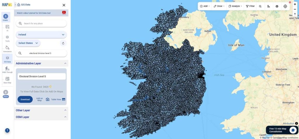
Begin by selecting GIS Data tool. Choose “Ireland” in select country panel. Then, you can get the Electoral Division Level 5 in other layer or use the search layer function to locate “Electoral Division Level 5 “. Before proceeding, attributes can be reviewed to determine whether the information is available as polygons or other geometry types.
Step 2: Refine Results with Data Filters
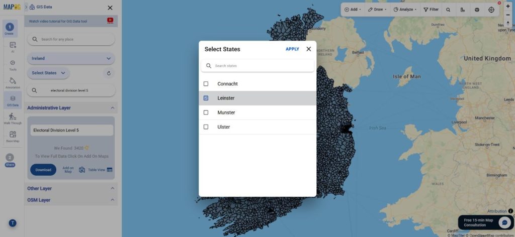
The Filter Data option enables users to narrow down results further. State and district-based filtering can be applied to obtain more targeted datasets. As a result, only the most relevant information is displayed, which significantly improves data accuracy and usability.
Step 3: Add Data to the Interactive Map
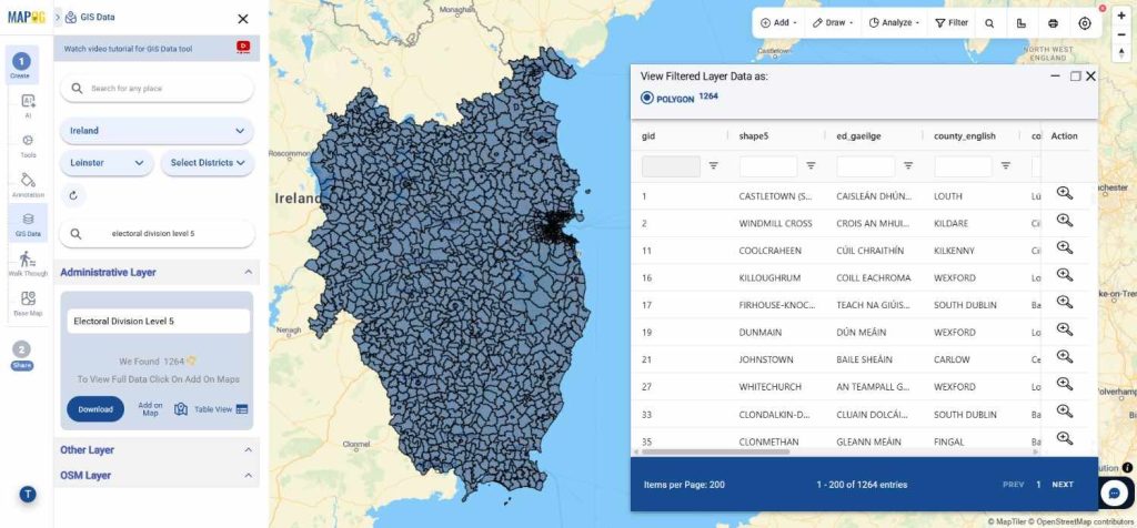
Once the desired layer has been identified, the “Add on Map” feature can be used to display the dataset within the map analysis interface. This allows spatial relationships to be explored visually and supports advanced analysis. In addition, multiple layers can be combined for more comprehensive insights.
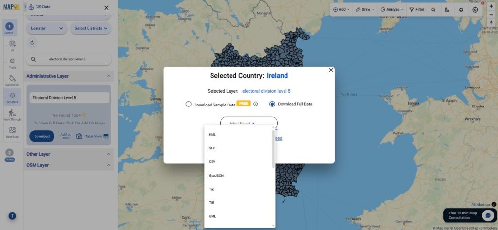
Step 4: Download the Dataset
After reviewing the data, users can proceed to Download Ireland Electoral Division Level 5 Data in either sample or complete versions. Multiple export options are available, including Shapefile, KML, MID, GeoJSON, CSV, SQL, DXF, MIF, GPX, and more than 15 GIS-supported formats. Once the terms and conditions are accepted, the dataset can be downloaded instantly.
Final Thoughts
With GIS Data by MAPOG, obtaining high-quality administrative boundary datasets has become simple and efficient. Whether the data is required for geographic research, regional planning, statistical studies, or visualization purposes, the platform offers flexibility through numerous GIS-compatible formats. Therefore, professionals and GIS enthusiasts can confidently Download Ireland Electoral Division Level 5 Data and integrate it seamlessly into their mapping and analytical workflows.
More Helpful Datasets From Ireland:
Download Shapefile for the following:
- World Countries Shapefile
- Australia
- Argentina
- Austria
- Belgium
- Brazil
- Canada
- Denmark
- Fiji
- Finland
- Germany
- Greece
- India
- Indonesia
- Ireland
- Italy
- Japan
- Kenya
- Lebanon
- Madagascar
- Malaysia
- Mexico
- Mongolia
- Netherlands
- New Zealand
- Nigeria
- Papua New Guinea
- Philippines
- Poland
- Russia
- Singapore
- South Africa
- South Korea
- Spain
- Switzerland
- Tunisia
- United Kingdom Shapefile
- United States of America
- Vietnam
- Croatia
- Chile
- Norway
- Maldives
- Bhutan
- Colombia
- Libya
- Comoros
- Hungary
- Laos
- Estonia
- Iraq
- Portugal
- Azerbaijan
- Macedonia
- Romania
- Peru
- Marshall Islands
- Slovenia
- Nauru
- Guatemala
- El Salvador
- Afghanistan
- Cyprus
- Syria
- Slovakia
- Luxembourg
- Jordan
- Armenia
- Haiti And Dominican Republic
- Malta
- Djibouti
- East Timor
- Micronesia
- Morocco
- Liberia
- Kosovo
- Isle Of Man
- Paraguay
- Tokelau
- Palau
- Ile De Clipperton
- Mauritius
- Equatorial Guinea
- Tonga
- Myanmar
- Thailand
- New Caledonia
- Niger
- Nicaragua
- Pakistan
- Nepal
- Seychelles
- Democratic Republic of the Congo
- China
- Kenya
- Kyrgyzstan
- Bosnia Herzegovina
- Burkina Faso
- Canary Island
- Togo
- Israel And Palestine
- Algeria
- Suriname
- Angola
- Cape Verde
- Liechtenstein
- Taiwan
- Turkmenistan
- Tuvalu
- Ivory Coast
- Moldova
- Somalia
- Belize
- Swaziland
- Solomon Islands
- North Korea
- Sao Tome And Principe
- Guyana
- Serbia
- Senegal And Gambia
- Faroe Islands
- Guernsey Jersey
- Monaco
- Tajikistan
- Pitcairn
Disclaimer : The GIS data provided for download in this article was initially sourced from OpenStreetMap (OSM) and further modified to enhance its usability. Please note that the original data is licensed under the Open Database License (ODbL) by the OpenStreetMap contributors. While modifications have been made to improve the data, any use, redistribution, or modification of this data must comply with the ODbL license terms. For more information on the ODbL, please visit OpenStreetMap’s License Page.
Here are some blogs you might be interested in:
- Download Pharmacy Data in Shapefile, KML, GeoJSON, and More – Filter and Download
- Download ATM Data in Shapefile, KML, MID +15 GIS Formats Using GIS Data by MAPOG
- Download Road Data in Shapefile, KML, GeoJSON, and 15+ GIS Form
- Download Airport data in Shapefile, KML , MIf +15 GIS format – Filter and download
- Download Bank Data in Shapefile, KML, GeoJSON, and More – Filter and Download
- Download Railway data in Shapefile, KML, GeojSON +15 GIS format
- Download Farmland Data in Shapefile, KML, GeoJSON, and More – Filter and Download
Leave a Reply