GIS Data by MAPOG is a user-friendly platform designed to help users download drains data in multiple GIS formats like Shapefile, KML, and GeoJSON. With an intuitive interface, it allows seamless access to administrative and geographic datasets, making it easy to analyze drainage networks worldwide. Whether you’re working on urban planning, flood management, or infrastructure projects, this tool provides the precise spatial data you need.
What is Drains Data?
Drains data represents networks of drainage systems, including stormwater channels, sewage lines, pipelines, and natural water flow paths. It is crucial for hydrological studies, city planning, and environmental management. Having accurate drains data enhances flood mitigation, water management, and disaster preparedness.
Download Drains data of any countries
Note:
- All data is provided in GCS datum EPSG:4326 WGS84 CRS (Coordinate Reference System).
- Users need to log in to access and download their preferred data formats.
Step-by-Step Guide to Download Drains Data
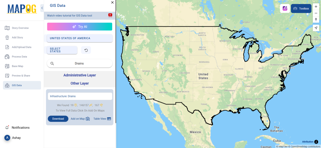
Step 1: Search for ‘Drains Data’
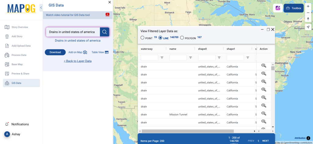
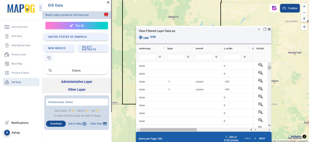
Log in to GIS Data by MAPOG. Choose your preferred country and use the search option to find Drains data layers. These layers may include pipeline routes, underground drainage networks, and surface water drains. You can check whether the data is available in point or polygon format.
Step 2: Utilize the AI Feature
The Try AI tool, available at the top left corner, helps streamline your search. Simply enter “Drains Data” along with the region of interest, and the AI will fetch the most relevant dataset for you.
Step 3: Apply Filters for Accuracy
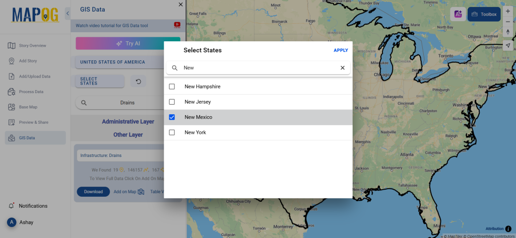
Use the filter option to refine your data based on specific states, cities, or districts. This ensures you extract only the most relevant drains dataset, improving precision in mapping and analysis.
Step 4: Visualize with ‘Add on Map’
Before downloading, use the Add on Map feature to overlay the drains dataset onto a GIS interface. This helps in understanding spatial relationships, flow directions, and infrastructure alignments.
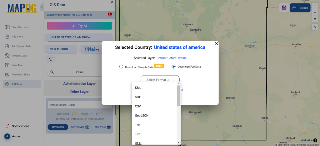
Step 5: Download the Data
Click the Download Data button. You can choose between sample data or the full dataset. Select from formats like Shapefile (SHP), KML, GeoJSON, MID, or any of the 15+ supported formats. Accept the terms and conditions, then proceed with the download.
Conclusion
With GIS Data by MAPOG, downloading drains data is effortless. This platform offers an extensive range of GIS datasets, helping engineers, planners, and researchers make informed decisions. Whether you’re working on urban drainage planning or flood risk assessment, this tool ensures you have precise and reliable data at your fingertips.
With MAPOG’s versatile toolkit, you can effortlessly upload vector and upload Excel or CSV data, incorporate existing layers, perform polyline splitting, use the converter for various formats, calculate isochrones, and utilize the Export Tool.
For any questions or further assistance, feel free to reach out to us at support@mapog.com. We’re here to help you make the most of your GIS data.
Download Shapefile for the following:
- World Countries Shapefile
- Australia
- Argentina
- Austria
- Belgium
- Brazil
- Canada
- Denmark
- Fiji
- Finland
- Germany
- Greece
- India
- Indonesia
- Ireland
- Italy
- Japan
- Kenya
- Lebanon
- Madagascar
- Malaysia
- Mexico
- Mongolia
- Netherlands
- New Zealand
- Nigeria
- Papua New Guinea
- Philippines
- Poland
- Russia
- Singapore
- South Africa
- South Korea
- Spain
- Switzerland
- Tunisia
- United Kingdom Shapefile
- United States of America
- Vietnam
- Croatia
- Chile
- Norway
- Maldives
- Bhutan
- Colombia
- Libya
- Comoros
- Hungary
- Laos
- Estonia
- Iraq
- Portugal
- Azerbaijan
- Macedonia
- Romania
- Peru
- Marshall Islands
- Slovenia
- Nauru
- Guatemala
- El Salvador
- Afghanistan
- Cyprus
- Syria
- Slovakia
- Luxembourg
- Jordan
- Armenia
- Haiti And Dominican Republic
- Malta
- Djibouti
- East Timor
- Micronesia
- Morocco
- Liberia
- Kosovo
- Isle Of Man
- Paraguay
- Tokelau
- Palau
- Ile De Clipperton
- Mauritius
- Equatorial Guinea
- Tonga
- Myanmar
- Thailand
- New Caledonia
- Niger
- Nicaragua
- Pakistan
- Nepal
- Seychelles
- Democratic Republic of the Congo
- China
- Kenya
- Kyrgyzstan
- Bosnia Herzegovina
- Burkina Faso
- Canary Island
- Togo
- Israel And Palestine
- Algeria
- Suriname
- Angola
- Cape Verde
- Liechtenstein
- Taiwan
- Turkmenistan
- Tuvalu
- Ivory Coast
- Moldova
- Somalia
- Belize
- Swaziland
- Solomon Islands
- North Korea
- Sao Tome And Principe
- Guyana
- Serbia
- Senegal And Gambia
- Faroe Islands
- Guernsey Jersey
- Monaco
- Tajikistan
- Pitcairn
Disclaimer : The GIS data provided for download in this article was initially sourced from OpenStreetMap (OSM) and further modified to enhance its usability. Please note that the original data is licensed under the Open Database License (ODbL) by the OpenStreetMap contributors. While modifications have been made to improve the data, any use, redistribution, or modification of this data must comply with the ODbL license terms. For more information on the ODbL, please visit OpenStreetMap’s License Page.
Here are some blogs you might be interested in:
- Download Airport data in Shapefile, KML , MIf +15 GIS format – Filter and download
- Download Bank Data in Shapefile, KML, GeoJSON, and More – Filter and Download
- Download Railway data in Shapefile, KML, GeojSON +15 GIS format
- Download Farmland Data in Shapefile, KML, GeoJSON, and More – Filter and Download
- Download Pharmacy Data in Shapefile, KML, GeoJSON, and More – Filter and Download
- Download ATM Data in Shapefile, KML, MID +15 GIS Formats Using GIS Data by MAPOG
- Download Road Data in Shapefile, KML, GeoJSON, and 15+ GIS Form