
Exciting news for GIS enthusiasts! MAPOG has now expanded its GIS data collection to include the Democratic Republic of the Congo, among more than 100 other countries! Discover updated and comprehensive GIS data for the Democratic Republic of the Congo, featuring a diverse array of geographic and administrative features, such as waterbodies, road lines, airport locations, and more. From national to local levels, the dataset encompasses various administrative divisions, providing invaluable information for your mapping projects. Enjoy the convenience of choosing from ESRI Shapefile, KML, GeoJSON, and CSV formats for easy downloading. Don’t miss this incredible opportunity to elevate your mapping projects with the latest GIS data for the Democratic Republic of the Congo. Happy exploring and mapping!
With MAPOG’s versatile toolkit, you can effortlessly upload vector, add WMS (Web Map Service) layers, upload Excel or CSV data, incorporate existing files, perform polygon splitting and merging, generate new polygon and polyline data, use the converter for various formats, conduct buffer analysis, create grids, transform points into polygons, calculate isochrones, and utilize the geocoder for precise location information.
We have a diverse range of data formats, including KML, SHP, CSV, GeoJSON, Tab, SQL, Tiff, GML, KMZ, GPKZ, SQLITE, Dxf, MIF, TOPOJSON, XLSX, GPX, ODS, MID, and GPS, ensuring compatibility and accessibility for various applications and analyses.
If you want to know how to use Add GIS Data tool, check out this article Add GIS data from IGISMap GIS data collection.
Note:
- All data available are in GCS datum EPSG:4326 WGS84 CRS (Coordinate Reference System).
- You need to login for downloading the shapefile.
Download Shapefile Data of Democratic Republic of the Congo
The Democratic Republic of the Congo (DRC), also referred to as Congo-Kinshasa and formerly known as Zaire, is situated in Central Africa. It ranks as the second-largest country in Africa and the 11th-largest globally in terms of land area. Boasting a population of approximately 112 million, the DRC holds the distinction of being the most populous officially Francophone nation in the world. Its capital and largest city, Kinshasa, serves as both the political and economic hub. The DRC shares borders with the Republic of the Congo, Central African Republic, South Sudan, Uganda, Rwanda, Burundi, Tanzania (across Lake Tanganyika), Zambia, Angola, the Cabinda exclave of Angola, and the South Atlantic Ocean.

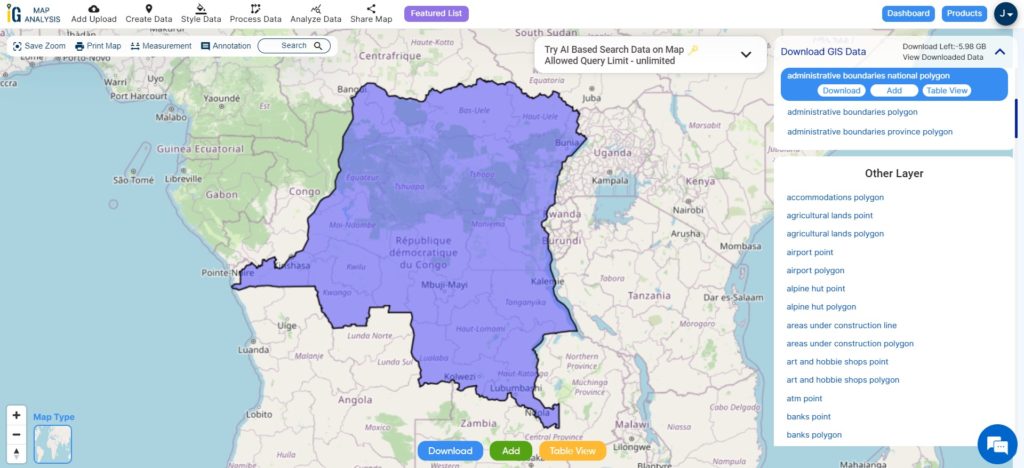
Download Congo Democratic Republic National Boundary Shapefile
After successfully logging in with a legitimate email address, select the country you want to work with. Next, choose the specific layer you need and click on the download option. Once that’s done, pick the desired format to acquire the essential GIS data. Before proceeding with the data download, make sure to review the data table for any relevant information.
Download Democratic Republic of the Congo Provinces Shapefile Data
The Democratic Republic of the Congo is divided into 25 named provinces, with the capital city of Kinshasa also holding the status of a province. As a result, Kinshasa is often considered as the 26th province in various contexts.

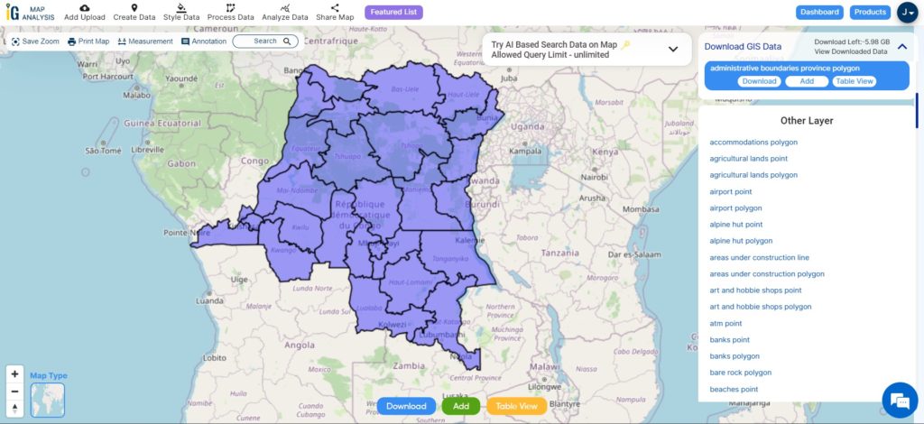
Download Congo Democratic Republic Provinces Shapefile
This shapefile covers following provinces of Congo Democratic Republic listed below:
- Kinshasa (Capital)
- Kongo Central (formerly Bas-Congo)
- Kwango
- Kwilu
- Mai-Ndombe
- Équateur
- Tshuapa
- Mongala
- Nord-Ubangi (formerly Nord-Ubangi)
- Sud-Ubangi (formerly Sud-Ubangi)
- Ituri
- Haut-Uélé
- Bas-Uélé
- Tshopo (formerly Orientale)
- Maniema
- Sud-Kivu
- Nord-Kivu
- Tanganyika
- Haut-Lomami
- Lualaba
- Haut-Katanga
- Haut-Lomami (formerly Katanga)
- Lomami
- Sankuru
- Kasai
- Kasaï-Central (formerly Kasaï-Occidental)
Download Democratic Republic of the Congo Administrative Boundaries Combined Shapefile Data
The Democratic Republic of the Congo is administratively divided into 26 provinces, along with cities, municipalities, territories, collectivities, and communes, serving as its combined administrative division structure.
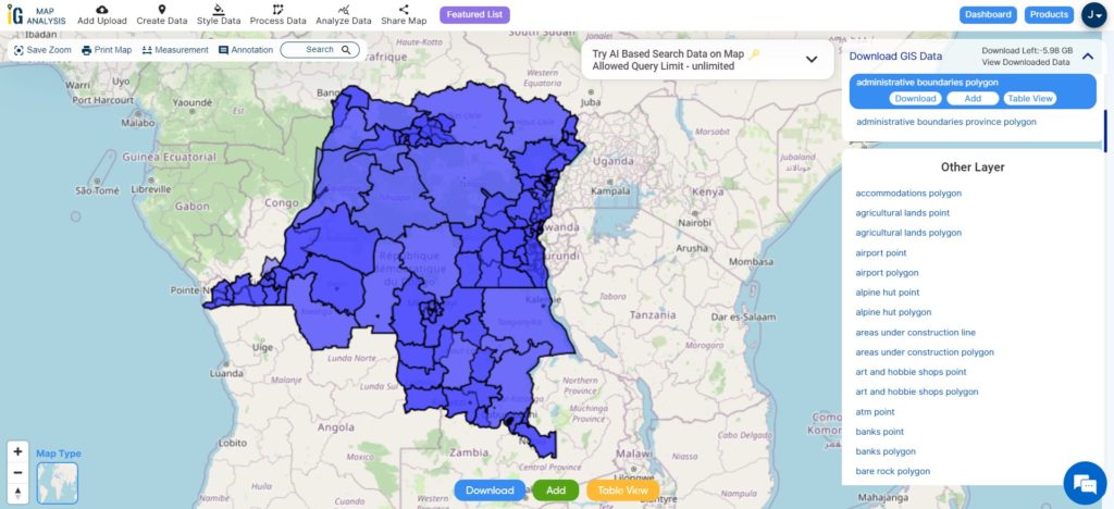
Download DRC National, Province, Sectors Shapefile
Other Administrative Boundary Data:
Other GIS Data:
- Download DRC Highway Lines Shapefile
- Download DRC Railway Lines Shapefile
- Download DRC Airport Point Shapefile
- Download DRC River Line Shapefile
Above all links are provided for GIS data of Democratic Republic of the Congo if you are looking for any specific data please write us on support@mapog.com
Download Shapefile for the following:
- World Countries Shapefile
- Australia
- Argentina
- Austria
- Belgium
- Brazil
- Canada
- Denmark
- Fiji
- Finland
- Germany
- Greece
- India
- Indonesia
- Ireland
- Italy
- Japan
- Kenya
- Lebanon
- Madagascar
- Malaysia
- Mexico
- Mongolia
- Netherlands
- New Zealand
- Nigeria
- Papua New Guinea
- Philippines
- Poland
- Russia
- Singapore
- South Africa
- South Korea
- Spain
- Switzerland
- Tunisia
- United Kingdom Shapefile
- United States of America
- Vietnam
- Croatia
- Chile
- Norway
- Maldives
- Bhutan
- Colombia
- Libya
- Comoros
- Hungary
- Laos
- Estonia
- Iraq
- Portugal
- Azerbaijan
- Macedonia
- Romania
- Peru
- Marshall Islands
- Slovenia
- Nauru
- Guatemala
- El Salvador
- Afghanistan
- Cyprus
- Syria
- Slovakia
- Luxembourg
- Jordan
- Armenia
- Haiti And Dominican Republic
Disclaimer : If you find any shapefile data of country provided is incorrect do contact us or comment below, so that we will correct the same in our system as well we will try to correct the same in openstreetmap.