Explore geography of China seamlessly with MAPOG. Access a diverse range of datasets, including boundaries, rivers, vegetation, and airports. Take advantage of user-friendly tools like Download GIS Data, providing formats such as Shapefile, KML, GeoJSON, and CSV. Delve into China GIS Data confidently with MAPOG.
With MAPOG’s versatile toolkit, you can effortlessly upload vector, add WMS (Web Map Service) layers, upload Excel or CSV data, incorporate existing files, perform polygon splitting and merging, generate new polygon and polyline data, use the converter for various formats, conduct buffer analysis, create grids, transform points into polygons, calculate isochrones, and utilize the geocoder for precise location information.
We offer an extensive array of data formats, including KML, SHP, CSV, GeoJSON, Tab, SQL, Tiff, GML, KMZ, GPKZ, SQLITE, Dxf, MIF, TOPOJSON, XLSX, GPX, ODS, MID, and GPS, ensuring compatibility and accessibility for various applications and analyses.
Note:
- All data available are in GCS datum EPSG:4326 WGS84 CRS (Coordinate Reference System).
- You need to login for downloading the shapefile.
Download Shapefile Data of China
China, spanning over 9.6 million square kilometers, boasts diverse landscapes, from the towering peaks of the Himalayas to the vast plains of the Yangtze River basin. Its capital, Beijing, stands as a symbol of its rich history and modern ambitions, nestled in the northern part of the country. With its immense size and varied terrain, China’s geographical features shape its cultural heritage and economic prowess on a global scale.
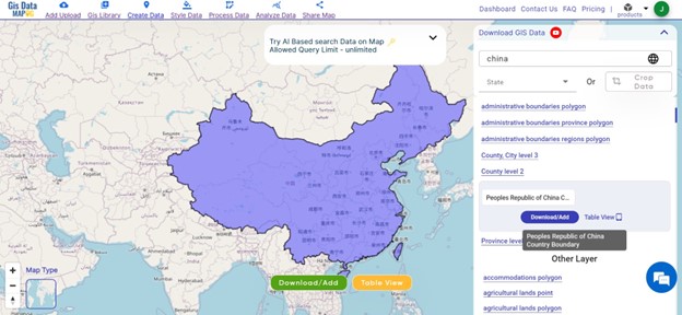
Download China National Boundary Shapefile
After successfully logging in with a legitimate email address, select the country you want to work with. Next, choose the specific layer you need and click on the download option. Once that’s done, pick the desired format to acquire the essential GIS data. Before proceeding with the data download, make sure to review the data table for any relevant information.
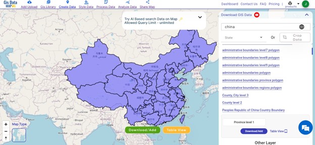
Download China Province Shapefile Data
China is divided into 34 administrative provinces,
here is a list of the 34 provinces of China:
1. Hainan Province
2. Shanghai Municipality
3. Beijing Municipality
4. Hong Kong Special Administrative Region
5. Guangzhou Province
6. Macau Special Administrative Region
7. Taiwan Province
8. Guangxi Zhuang Autonomous Region
9. Tianjin Municipality
10. Ningxia Hui Autonomous Region
11. Fujian Province
12. Yunnan Province
13. Guizhou Province
14. Jiangxi Province
15. Hunan Province
16. Zhejiang Province
17. Jiangsu Province
18. Chongqing Municipality
19. Hubei Province
20. Sichuan Province
21. Anhui Province
22. Henan Province
23. Shanxi Province
24. Qinghai Province
25. Tibet Autonomous Region
26. Shandong Province
27. Shaanxi Province
28. Gansu Province
29. Hebei Province
30. Liaoning Province
31. Jilin Province
32. Heilongjiang Province
33. Xinjiang Uyghur Autonomous Region
34. Inner Mongolia Autonomous Region
Download China Province Boundaries Shapefile
Download China Regions Shapefile Data
Districts in China are administrative regions, aiding local governance and services. They facilitate direct interaction between the government and communities, contributing to efficient development efforts. Please verify for recent changes.

Download China Regions Boundaries Shapefile
here is a list of the 6 District of China:
- Hong Kong
- Universidade de Macau em Ilha de Montanha
- Macau
- Macau
Other GIS Data:
- Download China Airport Polygon Shapefile
- Download China bank Point Shapefile
- Download China Road Lines Shapefile
- Download China Rivers Shape file
Above all links are provided for GIS data of China if you are looking for any specific data, please write us on support@mapog.com
Download Shapefile for the following:
- World Countries Shapefile
- Australia
- Argentina
- Austria
- Belgium
- Brazil
- Canada
- Denmark
- Fiji
- Finland
- Germany
- Greece
- India
- Indonesia
- Ireland
- Italy
- Japan
- Kenya
- Lebanon
- Madagascar
- Malaysia
- Mexico
- Mongolia
- Netherlands
- New Zealand
- Nigeria
- Papua New Guinea
- Philippines
- Poland
- Russia
- Singapore
- South Africa
- South Korea
- Spain
- Switzerland
- Tunisia
- United Kingdom Shapefile
- United States of America
- Vietnam
- Croatia
- Chile
- Norway
- Maldives
- Bhutan
- Colombia
- Libya
- Comoros
- Hungary
- Laos
- Estonia
- Iraq
- Portugal
- Azerbaijan
- Macedonia
- Romania
- Peru
- Marshall Islands
- Slovenia
- Nauru
- Guatemala
- El Salvador
- Afghanistan
- Cyprus
- Syria
- Slovakia
- Luxembourg
- Jordan
- Armenia
- Haiti And Dominican Republic
- Kiribati
Disclaimer: If you find any shapefile data of country provided is incorrect do contact us or comment below, so that we will correct the same in our system as well we will try to correct the same in OpenStreetMap.