Looking to download animal shelter data for mapping, emergency response, or urban planning? GIS Data by MAPOG makes it simple and efficient. With access to a wide range of GIS formats including Shapefile, KML, MID, GeoJSON, and more, this platform offers structured, reliable shelter datasets. Whether you’re involved in disaster preparedness, public welfare, or environmental studies, MAPOG provides detailed animal shelter data ready for integration into any GIS workflow.
How to Download Animal Shelter Data
MAPOG’s user-friendly interface makes accessing shelter data intuitive. With support for over 15+ GIS formats like KML, SHP, DXF, CSV, MIF, SQL, and TOPOJSON, users can easily integrate the data into their preferred GIS software.
Download Animal Shelter Data of any countries
Note:
• All data is provided in GCS datum EPSG:4326 WGS84 CRS (Coordinate Reference System).
• Users need to log in to access and download their preferred data formats.
Step-by-Step Guide to Access Shelter Datasets
Step 1: Search for Animal Shelter Layers
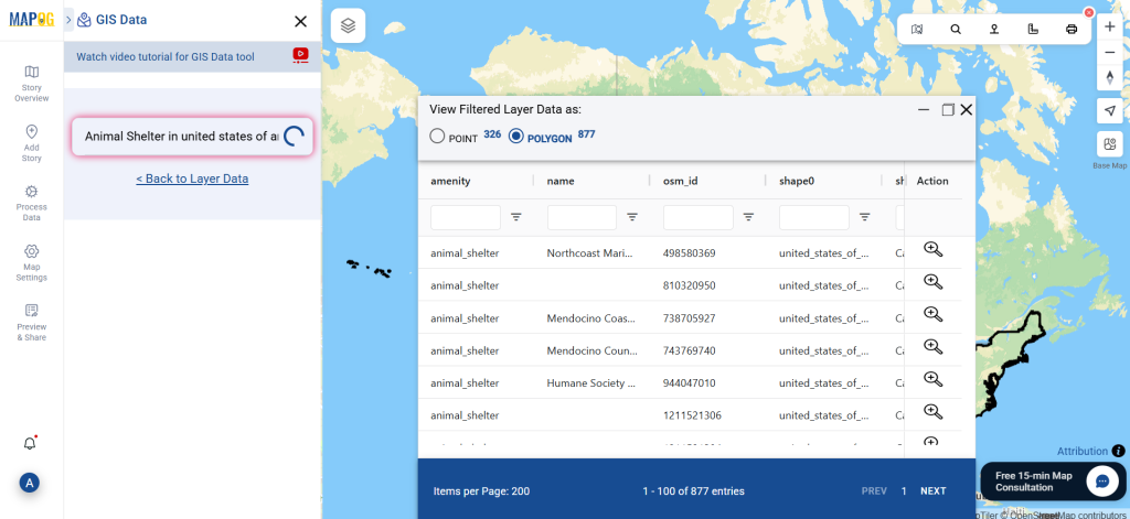
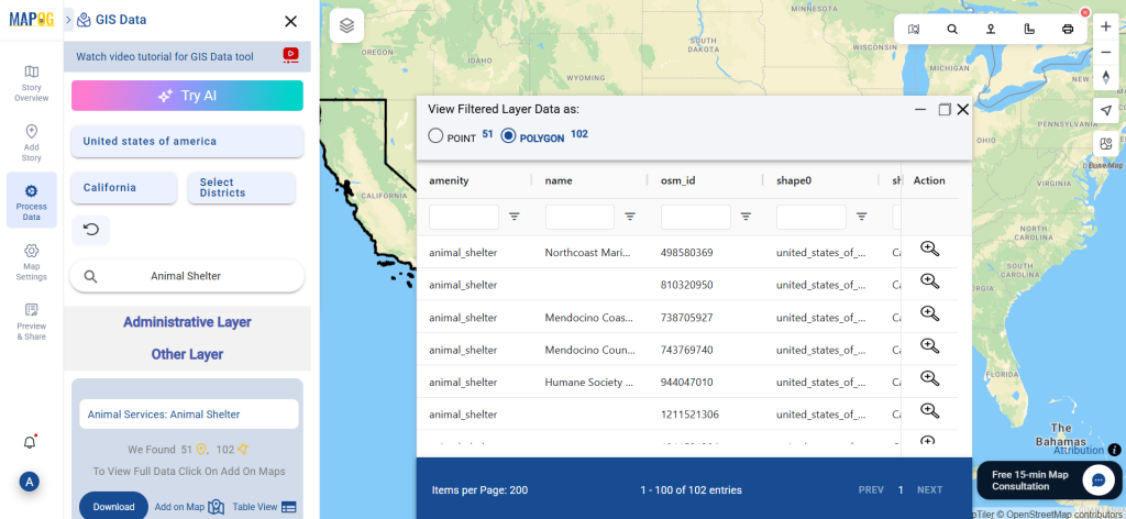
After coming in MAPOG interface click on Process data and under add upload data section , select GIS data. Begin by selecting your region of interest. Use the search tool to locate “Animal Shelter Data.” Check if the data is available as points or polygons based on your mapping needs.
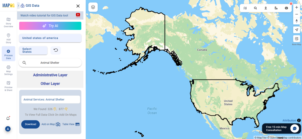
Step 2: Utilize the AI Search Tool
With MAPOG’s “Try AI” feature, typing phrases like “shelters near me” or “animal shelters in [location]” brings up the most relevant layers. This smart search saves time and improves result accuracy.
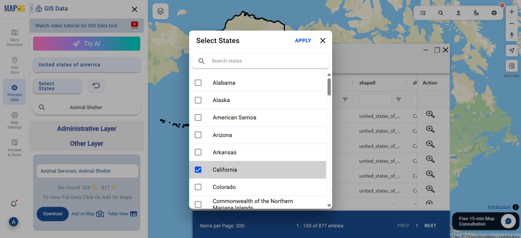
Step 3: Filter by Region
Narrow your search using the Filter Data tool. You can refine data by state and district, helping you target shelter locations with high precision and localized relevance.
Step 4: Add Data to Map
Click “Add on Map” to visualize your selected data. This interactive mapping view aids in analyzing shelter distribution, access routes, and potential coverage gaps.
Step 5: Download Animal Shelter Data
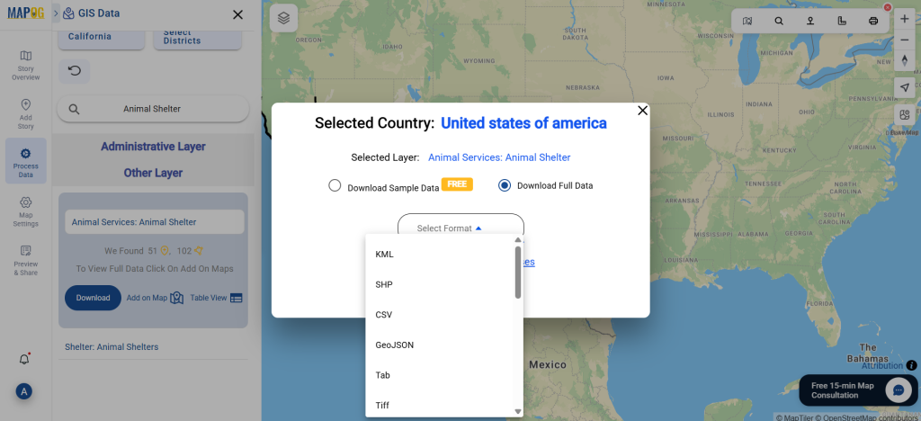
Once finalized, click “Download Data.” Choose between sample or full data and select the desired format—Shapefile, KML, MID, or others. Accept the terms, and your download is ready.
Final Thoughts
To sum up, MAPOG simplifies the entire process to download animal shelter data, making it accessible for both professionals and hobbyists. With detailed, ready-to-use shelter datasets in multiple formats, you’re equipped for better planning, research, and humane response strategies.
With MAPOG’s versatile toolkit, you can effortlessly upload vector and upload Excel or CSV data, incorporate existing layers, perform Split polygon by line, use the converter for various formats, calculate isochrones, and utilize the Export Tool.
For any questions or further assistance, feel free to reach out to us at support@mapog.com. We’re here to help you make the most of your GIS data.
❓ Frequently Asked Questions (FAQ) on Animal Shelter GIS Data
1. Where can I download animal shelter data for GIS mapping?
You can download animal shelter GIS data from MAPOG Dashboard. The platform provides structured datasets in formats like Shapefile, KML, GeoJSON, MID, and CSV, making it compatible with most GIS software.
2. Which GIS formats are available for animal shelter data?
MAPOG supports over 15+ GIS formats, including SHP, KML, CSV, GeoJSON, DXF, SQL, MID/MIF, and TOPOJSON. All data is provided in EPSG:4326 WGS84 CRS for global compatibility.
3. How do I filter animal shelter data by region?
Using MAPOG’s Filter Data tool, you can refine shelter data by country, state, or district. This ensures that planners, researchers, and NGOs get localized datasets for accurate analysis.
4. Can I preview animal shelter locations before downloading?
Yes. MAPOG allows users to click “Add on Map” to visualize animal shelter locations before downloading. This helps in identifying distribution patterns, accessibility routes, and service gaps.
5. Who can use animal shelter GIS data?
Animal shelter datasets are useful for:
- Urban planners – designing welfare infrastructure.
- Disaster response teams – locating shelters during emergencies.
- NGOs & researchers – studying animal welfare and public health.
- Government agencies – planning and monitoring community services.
6. Do I need to create an account to download animal shelter data?
Yes. Users need to log in to MAPOG to access and download full datasets in their preferred format.
7. Is the animal shelter data free?
MAPOG provides both sample datasets and full datasets. Sample data is often free, while full datasets may require access permissions or subscription depending on the coverage and format.
👉 Ready to explore? Get started here: Download Animal Shelter Data
Download Shapefile for the following:
- World Countries Shapefile
- Australia
- Argentina
- Austria
- Belgium
- Brazil
- Canada
- Denmark
- Fiji
- Finland
- Germany
- Greece
- India
- Indonesia
- Ireland
- Italy
- Japan
- Kenya
- Lebanon
- Madagascar
- Malaysia
- Mexico
- Mongolia
- Netherlands
- New Zealand
- Nigeria
- Papua New Guinea
- Philippines
- Poland
- Russia
- Singapore
- South Africa
- South Korea
- Spain
- Switzerland
- Tunisia
- United Kingdom Shapefile
- United States of America
- Vietnam
- Croatia
- Chile
- Norway
- Maldives
- Bhutan
- Colombia
- Libya
- Comoros
- Hungary
- Laos
- Estonia
- Iraq
- Portugal
- Azerbaijan
- Macedonia
- Romania
- Peru
- Marshall Islands
- Slovenia
- Nauru
- Guatemala
- El Salvador
- Afghanistan
- Cyprus
- Syria
- Slovakia
- Luxembourg
- Jordan
- Armenia
- Haiti And Dominican Republic
- Malta
- Djibouti
- East Timor
- Micronesia
- Morocco
- Liberia
- Kosovo
- Isle Of Man
- Paraguay
- Tokelau
- Palau
- Ile De Clipperton
- Mauritius
- Equatorial Guinea
- Tonga
- Myanmar
- Thailand
- New Caledonia
- Niger
- Nicaragua
- Pakistan
- Nepal
- Seychelles
- Democratic Republic of the Congo
- China
- Kenya
- Kyrgyzstan
- Bosnia Herzegovina
- Burkina Faso
- Canary Island
- Togo
- Israel And Palestine
- Algeria
- Suriname
- Angola
- Cape Verde
- Liechtenstein
- Taiwan
- Turkmenistan
- Tuvalu
- Ivory Coast
- Moldova
- Somalia
- Belize
- Swaziland
- Solomon Islands
- North Korea
- Sao Tome And Principe
- Guyana
- Serbia
- Senegal And Gambia
- Faroe Islands
- Guernsey Jersey
- Monaco
- Tajikistan
- Pitcairn
Disclaimer : The GIS data provided for download in this article was initially sourced from OpenStreetMap (OSM) and further modified to enhance its usability. Please note that the original data is licensed under the Open Database License (ODbL) by the OpenStreetMap contributors. While modifications have been made to improve the data, any use, redistribution, or modification of this data must comply with the ODbL license terms. For more information on the ODbL, please visit OpenStreetMap’s License Page.
Here are some blogs you might be interested in:
- Download Airport data in Shapefile, KML , MIf +15 GIS format – Filter and download
- Download Bank Data in Shapefile, KML, GeoJSON, and More – Filter and Download
- Download Railway data in Shapefile, KML, GeojSON +15 GIS format
- Download Farmland Data in Shapefile, KML, GeoJSON, and More – Filter and Download
- Download Pharmacy Data in Shapefile, KML, GeoJSON, and More – Filter and Download
- Download ATM Data in Shapefile, KML, MID +15 GIS Formats Using GIS Data by MAPOG
- Download Road Data in Shapefile, KML, GeoJSON, and 15+ GIS Form