Geographic Information System is a system intends to capture, Store, manage, manipulate, analyze the data. GIS system integrate data and convert it into maps. And as we know visuals are more powerful than words so it makes our understanding of data fast.
What is GIS ?
GIS is a tool to acquire geographic data and produce Geographic information. And generally those information are stored in tabular form. GIS can be defined as a “computer information system that can input, store, manipulate, analyze, and display geographically referenced (spatial) data to support decision making processes”.
Simply GIS visualize your data as a map. And these visualization makes the study interesting with interactive maps. It saves the time and make the system decisiveness that is main requirement.
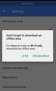
Google Map has changed a lot over a period of time,since the day Google has introduced its map and till the date it has been a very reliable map tool. One can excess map on desktop and on phone as well we have an application for Google maps, that we can download from play store or app store. Google map provides us with so many functions like navigation, finding or searching nearby locations, our history location is also been showed by Google maps. So moving on Google maps also take care of your pocket as well; that means it has introduced an option to control your data usage with Google Map Wifi Only Feature.
So you need to have go Google maps application in your android phone to enjoy this feature.
Once you enable this feature, you will be able to access maps and navigation in your downloaded area or whenever you are connected to WIFI.
Google Map WiFi Only Feature
Google Map Wifi Only Feature – Reduced Internet pack consumption
So you must be curious to know how to save your data on maps and navigation!
We will show you the way to do it, let’s check the following:-
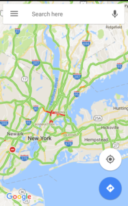
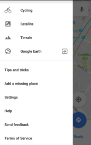
Tap the hamburger or menu icon at the top left corner of your mobile app.
Scroll down to select settings.
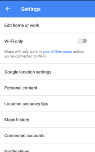
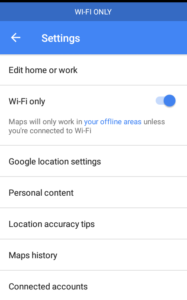
Once you open the settings you will find the WIFI only option in Google Map application.
Google Maps Wifi Only Feature – Helping Limit Data Usage
Right beside the’ WIFI only ‘ option is a toggle switch given
Tap the toggle switch to enable the ‘WIFI only’ option.
So, this is how Google lets you save your data in your Google Map Application and save you from burning a hole in your pocket, and parallel to it Google maps also allows you to use your maps and navigations in your downloaded area. Know the list of Google Map features.
Note: I don’t find WiFi only feature available in iOS app, but can be found in Android Google Map application. If you find this feature in iOS app too, do let us know by commenting below, we will recheck and update the article.
So how much Google map helped you with this do let us know in the comment box provided below.
Leaflet is small Javascript BSD Open Source license Map library, which helps in creating interactive map applications. Leaflet js Javascript library provides pre defined functions and variables which can be reused to add map layer, base map, points, line and polygon, where you can easily zoom in and zoom out. Also with the help of library you will be able to catch the events and define a function on it, for example, You can fetch all attributes or detailed information on a click over a polygon features which will be displayed in a popup.
Leaflet js – Getting started Create Map application
With leaflet you can compute the features bounding box, create a layer group, remove or add as many marker or different layer as you want on a map. Adding vector layers, raster layers, adding wms or wfs layer (can be used to serve and render geoserver or map server layers), selecting and hovering over lat-long are some of the functionality which can be easily grabbed by leaflet js map library.
Leaflet map library can be used in different platform like web app, mobile app or can be used in creating desktop application.
Also this small Map library so called as leafletjs is one of the easy to use and well documented library which is widely used by many GIS developers all over the world. Upon leaflet many developers have created different plugins which adds on the functionality to create an interactive map. Most of the plugins are available for free and can be used or recoded and integrated in your application. I found and used many plugins when required to do my clients work, as it save lots of time to do the same piece of work.
Here is the Github link of Lealfet and leaflet docs link:
Lets get started with code section of Leaflet js library:
Firstly you need to setup a Local Server. You can easily install and find either wamp or xammp server or any http server. Once installed or setup, we will first create a project folder in root www or public directory. Thereafter we will get started by creating one html file which we will use to code in leaflet js map example.
Once the html file created, under the head section paste following css and js cdn link of leafletjs map library:
Or you can either save and link those files directly in your local server. Under the body section create a division element with “map” as id:
<div id=“map” style=“height:300px”></div>
This division will render and display the map with the help of leaflet library. Lets initialize the map by adding a tile base map layer or either openstreetmap or mapbox or any other map provider tiles.
var newMap = L.map(‘map’).setView([38.9188702,-77.0708398], 13); //initiating the view providing the latitude and longitude with zoom layer as 13.
Above code will render openstreetmap tile layer. Proper attributes to the contributors can be easily added, which will be displayed at the bottom right corner of map screen in a descent way.
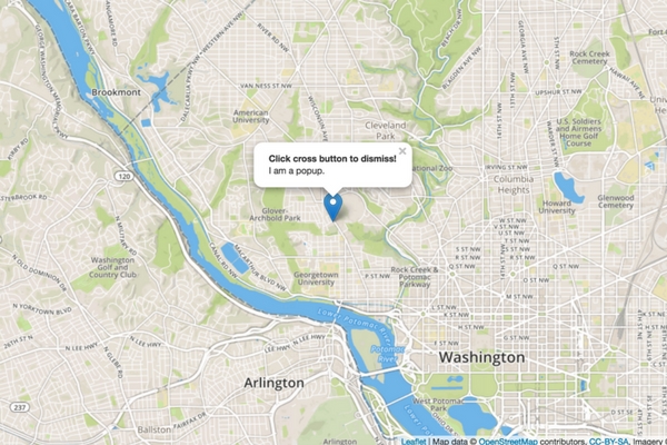
Finally we can add a marker and bind a click event, which will open up a popup with the message:
//binding popup event with leaflet marker and map L.marker([38.9188702,-77.0708398]).addTo(newMap) .bindPopup(“<b>Click cross button to dismiss!</b><br />I am a popup.”).openPopup();
Now we are all done with setup. Lets see how the leaflet getting started simple map example look like:
Above leaflet code will provide a output in browser as provided below:
Output – Leaflet js – Getting Started to create Map Application
Geojson or topojson are two of the most common files which can be easily added as vector layer map with the help of leaflet. Interactive Choropleth map is the best example which you can imagine to create in few hours or minutes of code with this library map.
In simple words you can take leaflet js as a library which will helps you to display and render your vector or raster layer data over browser or client side with some events handling over it. Unlike Google map library it does not provide geocoding or direction api or a basemap layer, but if you have geographical data or GIS data set, then with the help of provided data, your algorithm and leaflet library you can create and display the map as you want.
I hope this tutorial of getting started with leaflet would helped you to kick start with leaflet js library. Do subscribe to our blog, to get all latest updates, tutorials and news of map and GIS. Your comments are welcome either as question, comment or suggestion.
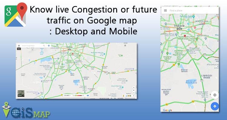
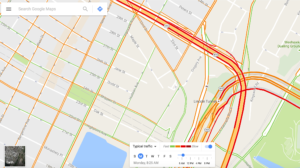
Know live traffic or predicted traffic on Google map. Are you planning for a road trip to either attend an important meeting, or to visit somewhere in a limited time. Don’t get afraid of reaching late at destination due to unusual traffic, as Google Map comes with its supreme feature of knowing live traffic condition at real time as well as predict the future traffic accordingly. Currently Google Map gives real time traffic condition and prediction for over 50 countries. Knowing traffic of a location without visiting the same physically at any time, isn’t it an amazing technology. Lets see an introduction of how Google Map provides live traffic and how one can use traffic feature of Google map on Desktop or laptop and also on Devices.
Know live Congestion or future traffic on Google map
Introduction : How Google detect traffic condition
Lets have a quick introduction paragraph to know how traffic is detected by Google. Earlier, Google provided traffic data based on running algorithm on historical data, which doesn’t comes out to be so accurate. After that Google uses third party data and tools and now with the help of Crowd-sourcing, Google made a very fine judgment of traffic.
Yes, Google gather live data from the crowd. All those people who are currently using Google Map or using Android device with Location tracking or GPS enable, are eventually providing anonymous data to Google with speed and location information. This makes Google to track live data, process the data with algorithm to determine congestion considering all important factors and limitations and ultimately used to render the traffic layer on Google Map for free to all users.
Mostly Google covers highways and arterials roads to predict the traffic, when data is available. This data is stored on Google database servers. Ultimately Google apply mining process on this data and run prediction algorithm to provide “Typical Traffic” or “Future Traffic” behavior.
Know live Congestion or future traffic on Google map
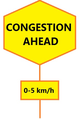
Google Map Traffic Color Shows speed of traffic on road:
Speed of traffic is shown in four different color i.e
Green: Means no traffic.
Yellow: Means there is some traffic, while it is tolerable and you could drive easily.
Orange: Means there’s a medium amount of traffic and you may be delayed with this.
Dark Red: A heavy traffic, means there are traffic delays.
Two other colors indicates:
Blue: This line indicates your direction routes on Google Map.
Gray: Indicates there is no data.
Steps to know live traffic or real time traffic on Google map on Desktop:
1.) Open Google Map on browser.
2.) Now write “Traffic” on the search input box provided, and press enter or search button. This would take you to your current location with live traffic layer displayed.
Or
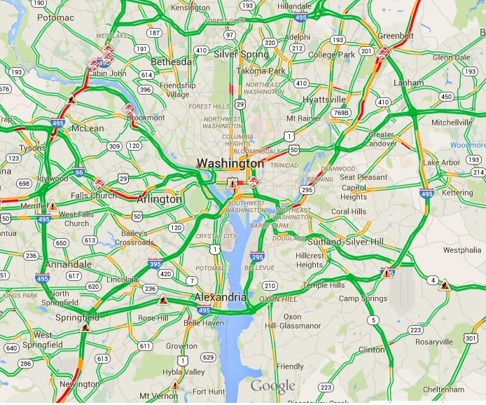
You may write “Traffic near ‘place’” for example “traffic near Washington, DC, USA”. And press enter. This would display area of Washington DC with traffic layer on screen.
Know live Congestion or future traffic on Google map
3.) Now you may see detailed view of traffic by zooming in or out.
Traffic incidents let several delays. Google Map also indicate incidents while viewing traffic. Here are the few of the symbols you may see:
Accidents
Construction
Road closures
Other incidents
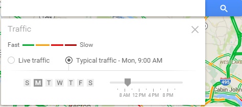
Steps to See the future prediction of traffic on Google Map – Desktop :
This is typical traffic which Google provides as a feature on Map, where traffic for an area based on the day of week and time can be searched and predicted. Here is the way to do it:
Update: Following are the updated steps i have found to predict the future traffic, as there is some UI changes in new Google map.
1.) You can either write traffic on the search box or open up the navigation menu and click on traffic button to get the colourful map displayed which enables traffic condition. By default live traffic is displayed on Google map.
2.) Now in the bottom center of the map, you need to click on drop down to switch to typical traffic.
3.) Now select the day and time to get the future traffic map. As you will click on the map and change the date and time, google will load new layer on map without loading the map where the map displays the predicted traffic at your desired location.
Know live Congestion or future traffic on Google map : Desktop and Mobile
Old Steps:
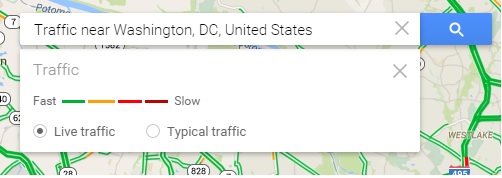
1.) Write “traffic” or “traffic near ‘place’” on the input search box provided and click on search button or press enter.
2.) Beneath the search box, you would find the two radio button labelled with ‘live traffic’ and ‘typical traffic’. Activate “Typical traffic” radio button.
Know live Congestion or future traffic on Google map
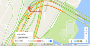
3.) Choose the day and time. This would refresh the new traffic map layer asynchronously, where you can see the predicted future traffic of particular day and time you selected of the location.
Know live Congestion or future traffic on Google map – Android or iOS device:
New version of Google map application for android or iOS device provides an easy way to know the current traffic condition of road.
1.) Open the Google Maps app in your android or iOS device.
2.) Touch the menu in the top left corner.
3.) Select Traffic button.
This would provide you a layer of traffic on Google Map.
Do remember Google do make sure to process and provide accurate traffic details, however there may be chances that due to some less data availability their may be inconsistency. Whats your experience while using Google Map Traffic feature? Do you get accurate data result? Do share us by commenting below. Also if you find any problem in implementing the above steps do comment below.
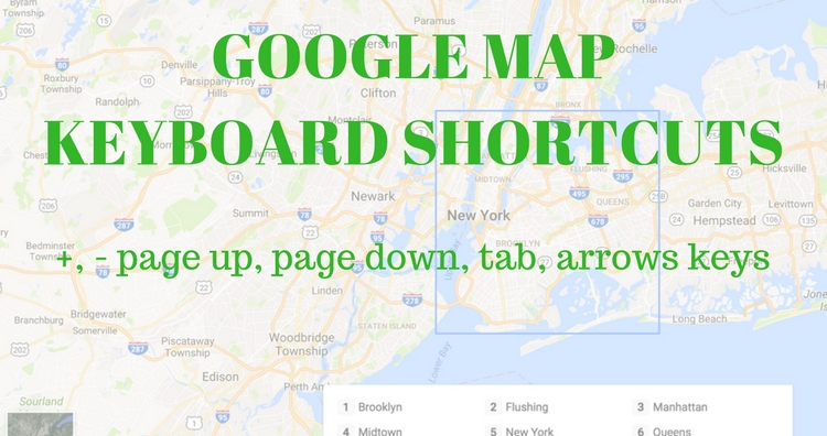
Google Map is one of the most famous Map tool used for finding near by point of interest, distance, area, traffic, and many more. Google map sure to provide the best possible solution to user, and so they also enabled a feature to control Google map with Keyboard Navigation. And they keeps update their feature day by day like introducing new navigation in 2016. While their navigation features was already enabled previously. There are many keyboard shortcut key. Here are some list.
Google map new Keyboard Navigation Controls Shortcuts
Google map new Keyboard Navigation Controls Shortcuts
Arrow keys i.e up, down, right and left: This will pan the map slightly north, south, east and west in Google map.
Home, End button, Page Up and Page Down button : This will pan wider as compare to arrow keys.
(+) Plus and (-) key : Zoom in and out the map respectively.
Double Right click : Zoom In the map.
Double Left click : Zoom out the Google map. (For mac users you need to double click with control button press i.e ctrl+)
Scroll wheel : Use mouse scroll to Zoom in and Zoom out in Google Map.
Google Map Street View Keyboard Shortcuts for control
Some keyboard shortcut of Google map which work while working on Google Street View mode.
Page Up key or ‘W’ button – move camera upwards i.e towards sky.
Page Down key or ‘S’ button – move camera downwards i.e towards ground.
Right arrow key or ‘D’ button – Rotate Right camera to 45 degrees.
Left arrow key or ‘A’ button – Rotate left camera to 45 degrees.
Note that Alphabets keys wont work while operating Google map on full screen mode.
Down arrow key – Move backwards along the direction of camera in Map
Up arrow key – Move Forward along the direction of camera in Google Map
Plus button or ‘+’ key – Camera view to zoom in one level
Minus button or ‘–’ key – Camera view to zoom out one level.
TAB key: If you press tab key, you will get all different controls of map for example you can see the rectangle on the map with some covered area, or you will get to the search box or to the right bottom control of the map.
Google map 2016 new Keyboard Navigation Controls Shortcuts
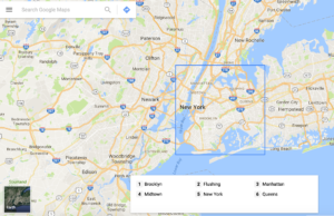
Along with this Shortcut which are very common, Google recently introduced in 2016 a new navigation Pan, zoom and find businesses on Google Maps without touching your mouse. You can also use your keyboard to find and learn more about specific places like neighborhood, transit stations and shops and restaurants.
On your keyboard, press Tab to focus the map. Here you will see the Square symbol on map with an area highlighted and listed in the pan with number list.
Google map new Keyboard Navigation Controls Shortcuts
Now you can navigate with arrow keys and the shift key hold along with the rectangle highlighted. To learn more about a place, press the number associated with the place.
Do you know any other keyboard shortcut for google map which is not listed here? Do comment below if you know any.
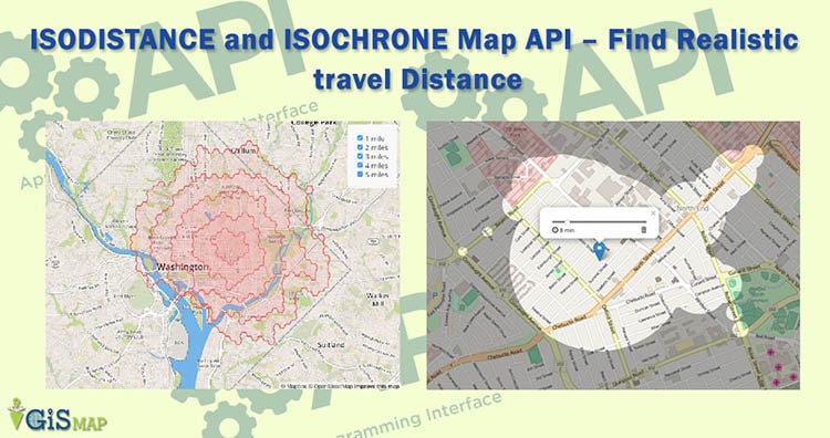
If we want to find out nearby hotels, coffee shop etc on google maps we can find it easily by just right clicking on the selected location and go for search nearby option. The map will show all the nearby selected hotels, coffee shop etc. I wonder how can I do this on a leaflet map with myself. In quest of this question I found Isodistance and Isochrone map APIs.
What are Isodistance and Isochrone maps?
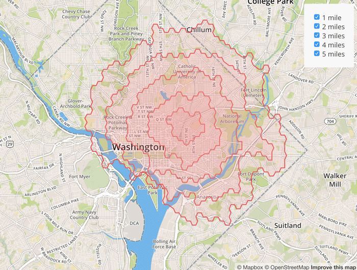
Isodistance maps:
An isodistance map is a map showing equal distance polygons from a point of interest considering every possible route. For example you decide to go for a morning walk daily for about 1 mile and you want to find out all the possible routes from your house on which you can walk ½ mile and then come back ½ mile, isodistance map is your solution.
As stated in Mapbox – “Isodistances offer realistic travel distances by considering roads and sidewalks, which can be the difference between a day at the beach and waiting for a tow truck.”
isodistance-mapbox
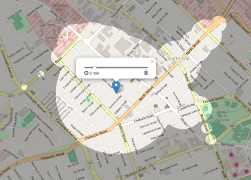
Isochrone maps:
halifax-map-isochrone
Isochrone maps are similar to isodistance map but here we consider time. An isochrone map is map which shows lines of equal travel time across a geographic area. As in the below snapshot example if you decide to walk 8 mins daily then you can find how much distance you might cover from your house in 8 mins.
APIs for Isodistance and Isochrone maps:
There are two APIs available for creating Isodistance maps. One is MapBox Directions API and another is ISO4APP API. This two APIs can be used with leaflet or google map. For Isochrone maps there is one API available that is ISO4APP API.
What you think about isodistance and isochrone maps? In which situtation are you using this algorithm? Do you know any other api which i have not listed? Do share your answer by commenting below in the area provided.
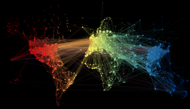
Flight Routes Network Analysis. When we think of Network analysis in GIS we think of roads, rivers, waterlines etc. In GIS two types of network are modeled. i.e:
1.)Transportation Networkfor example road networksand
2.) Utility Network for example gas pipeline network.
In transportation network model analysing air transportation network is afascinating network visualisation exercise.
FLIGHT ROUTES NETWORK ANALYSIS
Force-directed graph drawing algorithms are a class of algorithms for drawing graphs in an aesthetically pleasing way. This algorithm used by Martin Grandjean a researcher from The University of Lausanne, Switzerland to analyze the air transportation network created by 100,000 airline flights that take place around the world. Data for this analysis of the 3,275 airports across the globe was taken from openFlights.org.
A map showing flight routesbetween these airports is a network graph. Martin Grandjean attempts to make explicit the network behind air transport. The structure of the relationships has an impact on the spatial distribution of nodes in a graph. Let’s see how this landscape is reorganized without geographical constraints.
FLIGHT ROUTES NETWORK ANALYSIS
Explanation of the above image: “Naturally, network geography is not completely disrupted: the continents are mostly visible and regions are generally in their original position (with the exception of the Pacific islands that connect Asia and America – imagine this graph in three dimensions, with the Pacific Ocean behind). Major observations: India is more connected to the Middle East than to South and East Asia. The Russian cluster is very visible, connecting airports in Russia but also in many former Soviet republics. Latin america is clearly divided between a South cluster and a Central American cluster very connected with the U.S.”
I found this information very fascinating, to know the way for Flight Routes Network Analysis.
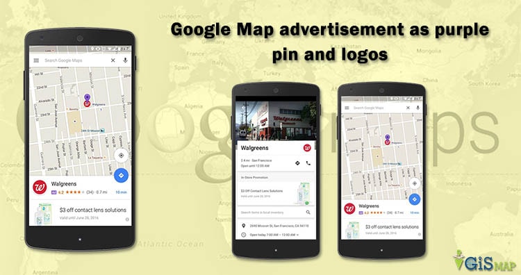
Google Map a giant, smooth and one of the fastest map is touching every part of your life by helping you find any location by just clicking on single search button. And now Google Map is looking to redesign its mobile experience of google Map by showing some relevant ads tagged as Google Map advertisement.
What are the Expected Type of Google Map advertisement:
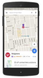
So what kind of ads would be shown on Google Map? Either as a purple pin on the map or as a logo would appear at its exact physical location on digital map, within the visible map area or near by you location. You can see an examples purple pin ad of ‘Walgreens’ as shown in the image provided below.
Google Map advertisement
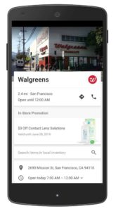
Along with pin ads Google map will also feature in-store promotions i.e when you expand a business page. Where you can see also see deals and coupon for sale items along with store hours and address. A small purple box with the word ‘Ad’ will highlight ad placements.
Google Map advertisement would appear in a subtle manner:
When will the ads will be shown? While the relevancy of ads would be better applied when you are using the app and searching for some kind of location. For example if you search for a nearby hotels, Google Map can show a purple promoted pin or its company logo which will be more attractive than any other.
Also while you are driving and using google Navigation function, a purple pin may appear sometimes, which locates nearby restaurant or gas station. This ads may be definitely be useful sometimes as people or driver would get aware of the location of some place of a route. As Google takes care of user experience so you don’t need to worry if ads might distract the drivers attention from the navigation route shown.
Final words
Obviously Google this effort is to make more money, i.e as ads will be shown to users where they receive more than a billion visit on a Google Map.
Although according to Google their first priority is to make sure the advertisement should be useful to users. Also for now, voice direction won’t have any audio advertisement, so that’s a good news while the bad part is that user would not be able to turn off the promoted pins.
Have you seen any Google Map ads till now? If so, please share your experience by commenting here below.
Merge two or more polygons, points or polyline of Shapefile in QGIS. Do you want to merge features of to combine them into one feature and to maintain its database dbf values along with it. QGIS – Quantum Geographic information system is of the most important for geographers and with the help of this tool I would demonstrate you to merge features within same layer. You can also have a look on how to merge more than two shapefiles.
If you haven’t installed QGIS, lets install Latest Quantum GIS first and open it up. Here are the steps to merge features of shapefile in QGIS.
Merge two or more polygons, points or polyline of Shapefile in QGIS:
We can merge two features in Shapefile in QGIS easily. Let’s say I have a Shapefile states.shp and I want to merge two states. Open up your QGIS tool.
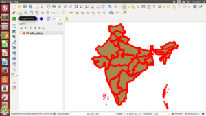
1.) Select the layer and click the toggle edit button from the toolbar.
2.) Click on select tool from toolbar as indicated in the image.
Merge two or more polygons, points or polyline of Shapefile
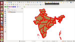
3.) Press control (ctrl) key and click on the features you want to merge to select them.
4.) Click on the Edit option where you can find find merge selected features.
Merge two or more polygons, points or polyline of Shapefile
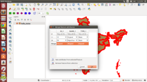
5.) You will see this window after selecting merge selected button.
6.) In the above dialogue box you can see there are three columns and four rows. In the first row you can select options for the fields so that what value you want to assign for the merged feature. Go ahead and try the given options.
7.) In the last row you can see the option you selected or you can delete that value by simply double clicking on the field and press delete from keyboard. After you are done you can click ok.
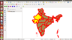
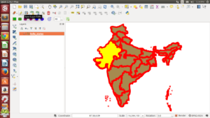
8.) You can see the features are merged. you can also check attribute table.
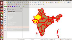
9.) click on save layer edits buttons and then click on toggle editing button if you are done.
Merge two or more polygons, points or polyline of Shapefile
That is all about merging two features of shapefile whether it is polygon, polyline or point features. If you are getting any problem in performing the above steps, do comment below, we would try to solve the problem by discussing over here.
Routing and displaying direction on Map along with showing the instruction for navigation, physical distance, traffic etc is one of the important part of GIS (Geographical Information System), when working on Travel or tourism or logistic projects. Are you Looking for the best Map direction API to create Routes on Web map or map on App? Researching for best performance and list of alternatives routing libraries? There are dozens of Routing API which is either available as premium API, Free till a limit or a completely free Routing API.
Here you will find all the list of Map Routing libraries which I have gone through and researched while working on one of my project. Let me start listing first few free and open source direction Map API followed with API which is available for free till a particular hits limits.
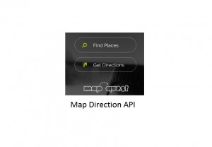
Map Direction API
You may also look over 8 Best Map Engine Alternative to Google Map Engine API.
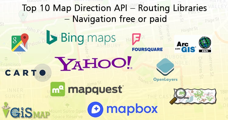
Top 10 Map Direction API – Routing Libraries
1.) Open Source Routing Machine:
OSRM computes shortest path in a graph and was designed to run well with map data from OSM project.
Can either be self hosted
Very fast routing.
Method of contraction hierarchies to compute shortest path routing, in contrast to A* which makes it very fast.
You can compare further maps from OpenStreetMap data routing section from here to get the detailed comparision of above listed API.
Premium Routing Libraries:
5.) Google Map Direction API:
We don’t need any introduction to Google Maps. Map with most data provides all roads in every mode whether it is for car, heavy vehicles, rails, bicycle or pedestrian. You just need to grab a key and use the API to get the directions.
Can access upto 2,500 free direction request per day.
Can add upto 23 waypoints
Can avoid route with tolls, highways, ferries and indoor.
Different languages are supported as an output result
Get the documentation link from here and get started with Google Map library.
6.) Bing Map Direction API :
Bing Map is another giant map service provider. You may look as an alternative of Google Map. You can customize, calculate and display direction and route on a Map with Direction API module or with Bing Map Rest Services. You need to get a Map key by registering in Bing Map. I didn’t found any figures of transaction which can be made free. But definitely if you over use the API either Microsoft will contact you or you may contact them either to upgrade the account as Enterprise.
Here are some features of Bing Map:
Calculate Route and get the walking, driving or transit route direction
Define way points
Get Road Shield images
Get Route data i.e Travel Distance, travel duration, estimated time of duration considering live traffic etc.
Turn by turn navigation instruction can be extracted.
You may also look at warning type i.e if there is a traffic accident, very slow traffic in the route, critical weather etc.
You can find the detailed document of the from here:
Bing Map Direction API
7.) ESRI Map Direction API:
ESRI is an international supplier of GIS software and databases and exist since 1969. ESRI Map provides AcrGIS API for JavaScript which helps you to get the Direction on Map. Register a developer account for free in ESRI direction and Routing Service website and get ready to use the library. You will get free development and testing subscription and also gets a 50 credits a month when you are ready to go to production. Yes they charge you according to credits, where each functionality have different credits for different number of hits. Here are some of the features:
Routes for pedestrian, light weight moving vehicle and heavy weight moving vehicle
Get optimized route considering traffic.
“Schedule stops, including people, pickups, work orders, and anything else, within a pre-defined time window.”
According to vehicle weight and height route will be calculated to clear restricted bridges and underpasses.
MapQuest Map provides Direction API with help of OpenStreetMap data. Upto 15,000/month Transactions is allowed for free. Here are the feature of MapQuest :
Get routes for different modes like pedestrian, bicycle, multi-modal.
Routes can be calculated as both fastest and shortest.
Instruction turn by turn navigation.
Get Estimated time of duration for a Route considering real time traffic.
Get Alternate routes for same origin and destination points.
According to date and time, optimized routes will be created.
You can have a look more over here of its documentation.
9.) MapBox Direction Map API:
MapBox is another popular API which can be considered as the best in terms of pricing and performance too. Here are the list of features:
Calculate optimal driving, walking and cycling routes.
Get turn by turn direction instructions.
Route can be created incorporating upto 25 waypoints anywhere on earth.
Get the geometry as a geojson file
Is free till 50,000 mapview either for mobile or for web
Take either shapefile or OSM data. Create R tree and generate the network graph. Implement A* or any shortest path alogrithm. Fix all issues and improve the speed. You are done.
Note: The limitation and features of API is listed on 12-01-2016 and can be changed time to time. So please check the actual price from the concerned API official website. Also features listed of each API is not complete, but just to give you introduction of the same.
The above list I found to be useful and you can choose one by comparing prices and features to implement in your project. Certainly there may be other routing API’s too, which you may not found here. But if you like the same and think that it should be present in the list, then do comment below with the name and some brief description of the map routing library.
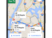
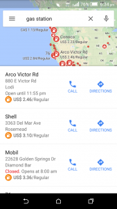
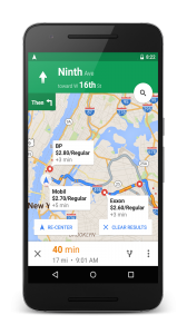
Are you running short of fuel at unknown place, while traveling form A to B? Wanted to track Near By Gas Station when there is no one to ask? Well, Google cares about your problem and so, they rolled out Android and iOS Google Map app update to locate Near By Gas Station along with other nearby search point of interest location.
Track Near by gas station and price on Google Map App
The only requirement to search for Gas Station is to have Google Map app in your device and a internet connection or if you have an offline area saved, then their is no need to have an internet connection too. Just grab your mobile open up Google Map and type “Gas Station” in the search box provided, which results out the near by Gas Station to you on the Map with red indicators as seen below. You can also increase the search area by providing the city name followed by ‘gas station’ keyword for example ‘San Francisco gas stations’.
Not only this, but Google Map would also try to help you in providing current rate of Different Gas Station in real time, which will definitely helps you to save some bucks comparing prices and lets you decide where you should fill your vehicle tank.
If you are in navigating mode, then the user can tap on a search icon, then select the gas stations from the drop down menu list which also includes coffee shops, restaurants and grocery stores as indicated by official blog for Google Maps.
Google Map track Near By Gas Station and Current Prices – Android and iOS Appne
This feature will really helps in real time while on a trip, in finding Gas stations when you notice your vehicle gas tank indicating nearing empty. What you think about this Google Map Features? Are you travelling regularly and finding the way to find near by Gas Stations? Is this feature helpful for you? Do share your valuable thoughts by commenting below in the space provided.