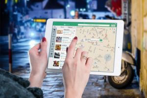
Geographic Information System is a system intends to capture, Store, manage, manipulate, analyze the data. GIS system integrate data and convert it into maps. And as we know visuals are more powerful than words so it makes our understanding of data fast.
What is GIS ?
GIS is a tool to acquire geographic data and produce Geographic information. And generally those information are stored in tabular form. GIS can be defined as a “computer information system that can input, store, manipulate, analyze, and display geographically referenced (spatial) data to support decision making processes”.
Simply GIS visualize your data as a map. And these visualization makes the study interesting with interactive maps. It saves the time and make the system decisiveness that is main requirement.
Earlier the basic necessities were limited to food, clothes and Shelter. As we all know , that, everything changes with the time, so has had happened with the basic necessities of an individual. Basic necessities of an Individual has also changed over a period of time. Telecom is an add on to the basic necessities of an Individual. Unlike, the earlier basic necessities, telecom has so much to do with technology. Of those technologies, GIS is the one playing major role for telecom Industry. Lets see, how GIS for Telecom is useful, reasons to use GIS for telecom.
Telecom Industry is one of the Vast and the Vital industry, serving its customers with varied number of players. Telecom Industry has enormous number of companies making it an Industry. It is a service providing industry, Consisting of telecom companies like IDEA, Airtel, Vodafone and many more are there.
GIS – Telecom Industry
Telecom industry makes us communicate over networks. It helps us to connect with our friends, family, relatives. Now here the question popping in our mind is how do they provide these services in every corner of the country, what might be the problems faced by them , how do they solve these problems?
Problems Faced by Telecom Industry :
Every Success is the result of Hardships and hardships can be done only by facing challenges. So, telecom industry too faces so many problems for satisfying its customers. The major Problems faced by telecom Industry are :
Capacity planning
Personnel management
market Segmentation
Real-Time knowledge of Network structure.
Demand Forecasting
Now, lets discuss what these problems stand for.
Capacity Planning : Capacity planning is related to the planning of providing the network to the each and every area of the country. Capacity planning is required to know the areas or locations where we need to focus for providing the services.
Personnel Management : The success of the company lies in its management. Management is responsible for managing the resources of the company. While, the management of personnel is a very crucial task. One needs to be very clear while allocating resources to the location according to the requirement.
Market Segmentation: Market Segmentation is the need of every business. No business can succeed without proper market segmentation. Segmentation of the market refers to the division of customers or consumers in different groups. One needs to be very careful while segmenting the market. As segmentation is one of the vital and major attribute of the Business.
Real-Time knowledge of network structure : Every Telecom company has to have the proper know how of network structure for any particular region at the given point or period of time .
Demand Forecasting : Demand forecasting again depends on the various attributes one of them is market segmentation and the previous data also helps in forecasting the demand.
These are all the problems faced by telecom industry, but the question is how do they deal with it. As it is not possible to evaluate everything regarding the area and the region on the basis of previous data or the printed maps. So now lets see what is the solution of these problems.
Check out Video – How to use IGIS Map in Telecom Sector Industry
Geographic Information System (GIS) for Telecom Sector Industry
The solution to all the above mentioned problems is GIS.
How GIS is the solution ?
GIS stands for geographic information system. It helps Telecom companies in solving their problems in the following ways :
GIS for Capacity management : As we know that capacity management is about the planning of providing the services to whom they have not reached yet. So GIS can help in locating the regions and areas on their Map, where they have not reached yet, or where they need to improve.
GIS for Personnel Management : GIS is very useful for allocating resources according to the requirements. GIS helps telecom company in identifying the areas where there is the requirement of the personnel. It also helps in identifying the number of personnel required, for which post they are required. All these can be done on the Maps with the help of GIS.
GIS for Market Segmentation : Market Segmentation can be done more efficiently on the maps with the help of GIS. One can easily divide the customers according to their groups, and then it becomes easy for them to allocate the towers for their network , where do they need to implant more towers, according to the complaints and grievances of the customer from different region.
GIS for Real Time Knowledge of Network Structure : Telecom industries can easily access their network points and signals, where are the signals reachable and where not, whether the signal is weak or good. It helps them in analysing the network status and structure as well for a particular region at particular point of time.
GIS for Demand Forecasting : Telecom Companies can use GIS for forecasting the demand of their products along with the help of the previous data and the market segmentation. With market segmentation company can know what is their target Market. It makes easy on the company’s perspective if they know well about their target Market.
These are the problems faced by telecom industry, and the ways in which GIS helps in solving these problems.
Do pen Down your experience with GIS in telecom, in the comment section provided below.
GIS (Geographic Information System) for Hospital Industry. ‘Health is wealth’, this quote is the truth. One can have everything with wealth but not health. One has to do so much to keep the health with them. But at some point of time everyone need an additional support to keep the health on track. That support we get from the Medical industry. Medical science has reached so up that now they have solution of every disease. There are many factors for a disease to occur. Medical Industry is one of the rapidly growing industry, for it is the must for every individual.
Though medical industry is a rapidly growing industry, but it also face some major problems. As we know that to reach to the top we face many hurdles in between. Although the medical industry is doing good but there is something, which helps or can help the medical industry to be better everyday. GIS helps Medical Industry to stay ahead with efficiency.
How GIS helps Medical or Hospital Industry ?
GIS is helping or can help the medical industry in enormous ways. Below mentioned are the major benefits that Medical Industry receive from GIS. GIS helps medical industry in following ways :
Now, lets understand these benefits and the GIS implementation for it .
GIS IN HOSPITAL INDUSTRY
Identifying Health Trends
Health trends varies from one region to another. A coastal region may not have some of the disease which are found in desert region. So this way the health trends varies from one region to another on the basis of various factors like – air, water, sunlight, food crops, food habits and many more. So, concerning all these factors one can identify the health trends, but to identify the regions one will surely need the GIS maps. With the help of GIS maps one can easily mark up the regions on the basis of these factors and can accumulate the health trends of that particular region.
Tracking the disease spread
While GIS helps in identifying the health trends, it is also capable of giving information regarding the spread of a disease. The spread of a disease refers to the communicable disease. How much communicable a disease is and where it is likely to spread next. So with the help of GIS this can be tracked. Tracking of a disease spread is important as this allows the doctors to take the preventive actions in prior, which can limit the spread of the disease.
Improved Services
Those who can satisfy their customers/consumers/clients with their services, are the one to achieve lots and lots of success. As far as Medical or hospital industry is concerned the better the service the happier the clients. With the help of GIS maps one can easily find out the disease spread regions, health trends, climate trends that prepares them in advance. The knowledge of health trends and disease spread in prior can limit the effect of the disease. Which eventually come up with the Improved services.
These are the benefits of using GIS in medical or hospital industry. If you know any more do let us know by commenting in the comment box provided below
Agriculture plays a very vital role in everyone’s life. For few agriculture is not the only way of having food in their plate, rather a source of income. We get food from agriculture, one can not imagine his life without agriculture. Agriculture brings food in our plate, hence the agriculture needs to be proper care taken of. Care of Agriculture depicts the farming according to the nature of the soil, land and water.
Say for an example, some staples are grown in the plateau regions, but can not be grown in plain area. There are various kind of agriculture activities, but the main part of agriculture is to decide where to do farming, and what to grow. Deciding on this is really a very crucial task. So, we have something which can assist you with this decision taking. That is GIS. GIS is helping people in every field, then why not agriculture. Yes, You read it right, GIS can assist in agriculture also. Lets see how GIS is helpful in Agriculture?
Benefits of GIS Maps in agriculture
GIS is beneficial to every one in every segment. Hence, it is beneficial for agriculture also. It provides agriculture with below mentioned benefits :
Lets see how GIS Maps provides with above mentioned benefits in agriculture.
GIS FOR AGRICULTURE
Climate Conditions
Climate is a variable that varies from region to region and sometimes within a region. As we know that Climate plays a vital role in agriculture sector, hence it is a necessity to give a proper and required focus on climate while planning for any farming or agricultural activity. Hence one can not easily find out the climate of a particular reason, as climate is made up of few factors like water,air sunlight. So, in such cases GIS maps can help in forecasting the climate of any region for farming anything. It would also help to let us know whether that crop can be grown in that particular region or not, with the help of GIS maps.
Know land type
No agriculture is possible without land, and no successful agriculture is possible without knowing the land type. Yes, As we know that land is an essential resource for agriculture but it is of no use if one does not know the land type of a region, as one can not grow a crop in deserted regions, which is mean to be grown in plateau regions. So, to identify a land type GIS maps are a must. GIS maps will help a person in finding out the Land type of a region for better results, One can easily mark those regions on GIS maps.
Water Supply
For growing the crops it is necessary to have water. We can not imagine our life without water, neither Can agriculture. So, to find out the water supply in a region we need to know the source of water of that region. That source can easily be find out With the help of GIS maps. GIS maps are the main source of information, of the factors of agriculture. You can easily identify the water bodies located near to a region and can accumulate the supply of water in that region.
Drought
Drought occurs because of the lack of water or rain. When there is no rain there will be no crops and food. Hence it is very important to know the drought prone regions, as to secure yourself from investing in such place where you might face some loss. So, GIS maps can help you find out those drought prone regions, on the basis of the previous data and GIS maps. With GIS maps you can get the details of the region which are drought prone.
These are the benefits one can receive from GIS maps for Agriculture. Use GIS maps for Telecom, BCP, Logistics, Medical industry and last but not the east Agriculture. If you know any more benefits of GIS For agriculture, do let us know by commenting below in the comment box of GIS For agriculture article.
We all love to travel, some travel for peace, some travel for business, some travel for a break from regular schedule and then some travel for experience. As they say ‘Don’t tell me how much educated you are, tell me how much you have traveled’. Traveling gives enormous experience, it fills up your soul, gives you a change, provides you with the peace of mind. Do you think to travel is an easy task ? Of course, travelling is very tempting, but to plan a trip is surely not a tempting thing, for it takes a lot of efforts and proper knowledge of the routes and the place. So, for keep the planning thing easy we have GIS maps. GIS maps offers some major benefits to Travels and tourism sector.
Lets see how these benefits are offered by GIS to travels and tourism sector .
Visualization Of Tourist Spot
Travels and Tourism is one of the wide and important industry, which is spread over all corner of the world. When you are travelling to a new place it is the responsibility of the travels and tourism business holder, to welcome their guests by making them visit every tourist spot. But for that we need to know the tourist spot of that place. So, in such cases GIS maps are very Useful. GIS maps helps in marking and finding out the tourist place, and through GIS ,customers can visualize those spots they are planning to visit.
Tourist Location
GIS helps in finding the tourist location to the travels and tourism business holders and their customers. With the help of GIS they can easily visualize the location while sitting at home and can also plan a tour to it, with the proper planning of your tour.
Route Planning
So, if you are planning a tour to a new state, then how would you be travelling there? how are you going to reach there ? So, for that we need not only navigation but a proper and efficient route. In such cases GIS maps are very useful, as they can help you in making the proper route for your tour. With the help of GIS you can plan your route by making the best efficient routes and can choose one of them that is more feasible to you.
Accommodation
Travelling to a new place, that is so exciting, but you get stuck when it comes to the food and stay, that means about your accommodation. GIS maps can help you out with this major problem. As we know, now we can look for the hotels and restaurants of any area very easily over Maps. Hence, You do not need to worry about the accommodation facility. All you need to do is just use GIS maps and get the best accommodation facility to stay according to your preferences, which is nearby to the tourist spots you are going to visit.
Cultural Events and Special attraction
We travel to explore new places and the culture and special attraction of that place. So, for finalizing your tour you can use GIS maps. GIS maps is mostly used by the travelers and tourist to finalize their place to visit on the basis of the special attraction of that place and its culture. With GIS one can easily look for the cultural events and special attraction, moreover the business holders can also update such locations in the map.
These are the Some major benefits which GIS provides to Tour and travels industry. If you know any other such benefits of the GIS for tours and travels industry, do let us know by commenting below in the comment box of GIS for travels and Tourism industry.
GIS Stands for Geographic Information System. GIS is helping everyone in every field. Be it Telecom industry, Medical industry, Agriculture Sector, and there are many more industries which are using GIS on a regular basis.
So, to provide an ease of GIS, so many mobile applications are now available. So, here we are to introduce you with the best GIS applications for Android And IOS. In case if you have not visited our Previous article use of GIS – 16 different industries covered. Here is the link.
5 Helpful GIS Mobile Applications
5 Helpful GIS Mobile Applications – Free GIS App
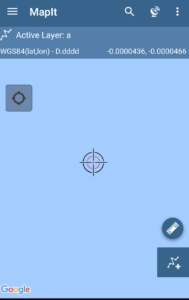
MapIt
SW Maps
Map With Us
MapPt
Locus GIS
These are the best 5 GIS applications for android and IOS. Lets Check what are the specialty of each of these GIS applications for Android and IOS.
1. MapIt – GIS Mobile application
MapIt is the another GIS application for android users. Mapit is widely used and one of the popular mobile application which is used for several purpose like environmental surveys,woodland surveys, road constructions, land surveying ,tree surveys, site surveys and soil samples gathering.
These are the sectors using MapIt GIS application, for Performing following functions –
Direct export to Dropbox or FTP location.
It has possibility to record multiple points ,lines and polygons on one layer.
Import/export attributes from file and much more to discover.
Address and location search .
You can also create new polygon or line features measurement details like area or length are also available.
possibility to group data into several layers.
it also allows you to local export or remote export.
It has Clusters for point map markers, efficient way of having large number of points on the map without performance issues.
support for WMS and ArcGIS .
it has possibility to create and maintain sets of attributes .
It provides base Map : Google Map, Bing Maps, Open street Maps, Mapbox.
SW maps is a free GIS application which helps you in collecting, sharing and representing Geographic information. No matter whether you are conducting full scale GNSS survey with high precision instruments,need to collect large amount of location based data using nothng but your phone,or just need to view a few shapefiles with labels over a background map on the go, SW Maps has it all covered.
SW Maps is one of the useful GIS application having following features :
Conduct high accuracy GPS surveys using external RTK capable receivers over blue tooth.
Draw features on the map by adding markers and measure distance and area.
online base maps are also available : Google Maps or open street view.
Support for mbtiles and KML over lays
it provides shape files layers, with categorized styling.
It also allows you to connect with external GPS.
draw point,line and polygons.
You can also label features based on attribute values.
you can also share and export the data in KMZ files
These are all about the SW Maps GIS application. you can download the SW Maps from here
3. Map with Us – GIS Mobile application
Map With us is one of the GIS application which is freely available on the google play store.Which provides following benefits to you :
Geolocate and upload photos,videos and audio
you can collect and edit the data in the field using custom data collection templates
Useful for business professionals
You will be able to easily export the collected data to KML files or shape files.
You can also import your KML or shape files to MapWithUs system.
These are the functions you can perform with Map with us GIS application. You can also download Map with us from here.
MapPt is one of the useful application which is available in 130 countries and in industries spanning from education and agriculture. This app is widely used by the people from below sectors :
Field mapping
Land surveying
Vegetation Management
Forestry Planning
Environmental management
incident reporting
Farm Mapping
Mine management
Government Planning
People are using Map with us because of the below functions that they can perform with it :
It allows you to create,edit,store and share all types of geospatial information.
You can geotagged photos and gridding.
Create points,polygons.polylines.
Import and export popular GIS formats such as shapefiles, JP2, and kml/kmz.
You can drop down forms for faster data collection.
Geofencing capabilities make sure you never breach a boundary.
you can also share the data between popular cloud storage like Google drive.
Locus GIS is a newly built app for the GIS professionals and enthusiasts. It is one of the GIS application for android and IOS users. This GIS application allows you to do following functions :
you can create your projects
you can also export the collected data to SHP file is fully compatible with ArcGIS Software
Select premium online and offline maps
It also provides advanced map tools like – map overlays,offsets,WMS sources support.
It also forecast the worldwide weather 24*7.
“Locus GIS application in beta version, which is valid till the end of 2017.”
These are all the 5 Helpful GIS Mobile Applications – Free GIS Apps available free of cost. If you know about any other such app do let us know by commenting below in the comment section of the 5 GIS applications for mobile which are helpful.
Humans are so clever that they easily secure their insecurity. We are afraid of loss. Be it our favorite bike, our expensive phone, our newly bought car, or our life. But we also want to secure our these insecurities and the solution for all of them is Insurance. Here we are going to discuss about the use of GIS in Insurance Industry. The insurance involves the insured or people assuming a guaranteed and known relatively small loss in the form of payment to their insurer or insurance company in exchange for the insurer’s promise to compensate the insured people in the event of a covered loss. In this modern society, you can get insurance of almost anything you want, it can be a phone or an island.Using GIS in Insurance
Industry is one of the highly profitable industries initiative in today’s time.
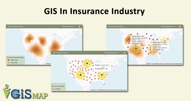
GIS In Insurance Industry
GIS can provides Insurance companies every location-based insight they need and It can also be used as Risk Manager as It uses smart maps, data analysis and all of the features for controlling risks and managing business strategies of Insurance companies.
Insurance companies also uses tools like Insurance Management GIS Web/App Development – Cost, Time – Map Tool. Visit the link for more information about the tool. lets get back to ask what is the major pillar of the Insurance company business and i think the answer is Location Information.
Location Information, like knowing about where your assets are located
and their closeness to hazards, is essential when developing risk
profiles for the Insurance Industries. GIS dispense tools that allow users to combine location-based data, such as road entry, and traffic
flow patterns, to make more informed decisions. This kinds of
information helps insurers to fulfill the requirements of their customers.
Benefits of GIS in Insurance Industry
GIS in Insurance Industry has the range of functions which allows the use of policyholders data and spatial analysis to effectively serve customers and monitor fraudulent activities by embracing location-based intelligence. Over the years, Insurance companies are getting really good at calculating risk because they hold a lot of risk.
GIS helps Insurance companies offer such low premiums for the high value insurances because with the help of GIS one Insurance company can divide a state into thousands of territory, which also divides the premium amount one has to pay.
GIS provides Geo-fencing, which is a virtual barrier in the real world. Geo-fencing is used in ca-rental or car-share to understand the limits of speed or drinking .
Uses of GIS in Insurance Industry
Insurance Risk Assessment : GIS understands the disaster proximity to improve the Insurance risk assessment. GIS helps location analytics provides an easy way for insurance companies to discover unknown problems, model situations, and implement the best solutions to minimize risk. Insurance risk assessment uses GIS to predict the risk. the level of risk decides the premium value. Higher risk extends higher premiums and lower premiums are for areas with less risk.
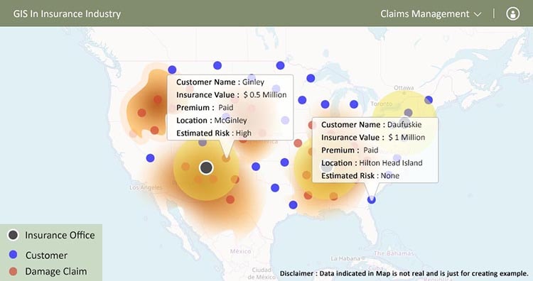
Claims Management : Insurance companies get the understanding about the Risk location and customers location from GIS. which helps in processing claims with respect to compensation, restoration, and repayment in response to the damage of the customers. This is the proactive approach to responding to customers with their claims rapidly and in an organized-way.
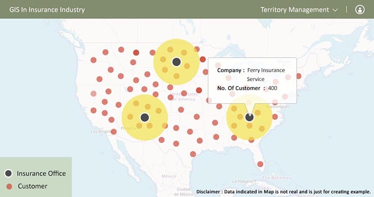
Territory Management: GIS helps Insurance companies in their territory management and the analysis shows how geography interacts with hazards and assets to help companies limit risk. GIS helps in implanting and deploying the networks necessary to operate efficiently in your territory.
Comparing Business Measures : You can easily map business measures and compare them with the help of GIS In Insurance Industry. It can validate various locations and visualize loss patterns on an interactive and beautiful maps.
The insurance industry expects to see more growth in Geo-spatial information in insurance as major players are getting involved in the technology. And this is why they have major needs of Insurance management tools. Do let us know how this Article is helpful for you, by commenting below in the comment box.
Logistics is the only one business which is the basic requirement of all the other businesses. Today every business has a need of transportation. Every business needs their products to come in the reach of general public. As it is known that the transportation basically relies on the routes. So in that case GIS and logistics are the counterparts of one coin. GIS would be the most optimum tool for the efficient logistics services. So, lets check how can we use GIS in Logistics.
What is logistics ?
Logistics is a service providing industry, which provides services to the other business and to the individuals as well. The main service provided by the Logistics is Transportation. We need transportation every now and then. But these logistics services are highly used by the product based industries.
Lets see how helpful is GIS in logistics :
GIS is one of the major player of the logistics industry. GIS helps the Logistics for following aspects :
Pre-Planning
Allocating the resources
Transportation routing
Navigation
Fleet Management
GPS tracking
Vehicle Finance
Cost Reduction.
The help provided by GIS in Logistics is performing all these tasks efficiently. Lets move further with the briefing of these tasks and the help that GIS provides.
GIS in Logistics
GIS for Pre Planning:
Pre planning refers to the making plans prior to the time of providing services. For pre planning we have two major constraints they are :
Allocating the resources
Transportation Routing
lets discuss these two in a brief that how We use GIS for these two tasks of pre planning.
Allocation of the Resources : The First and the Foremost function of the Pre planning is to allocate the resources efficiently. But how? So, whenever we receive a new order we can look for our resources which are close to the location and can reach there to load the stuffs with the optimum efficiency. So, you can do this by using any GIS application like Google maps or any other Customized apps created for the Logistics service provider.
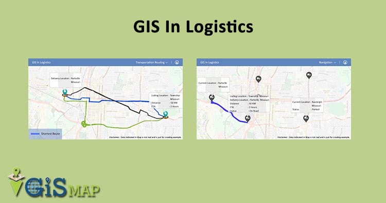
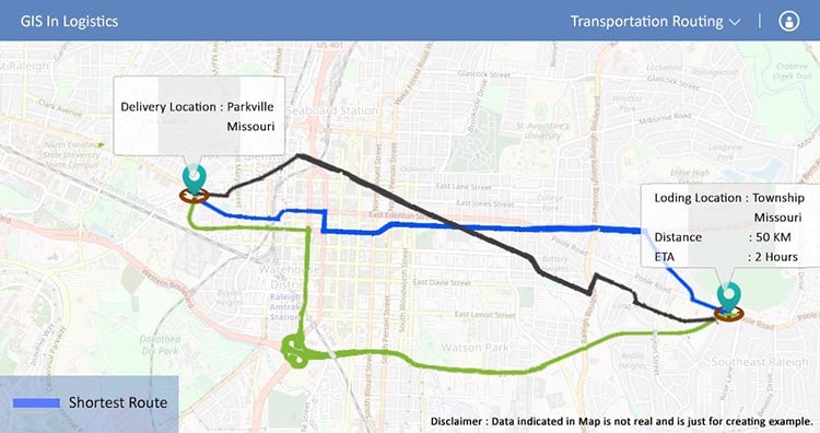
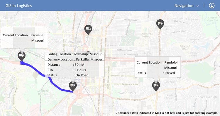
Transportation Routing : Providing a service and providing effective and efficient service both are far different having a slim line difference. That is the service is on time , without making any defects to the products. So we can route the resources with the help of GIS applications like maps. So maps will show you the best route, the shortest routes from loading Location to the Delivery Location.
Navigation :
Navigation is again the way to get the routes which we have planned before leaving for the delivery of the products to the respective location. So GIS would be helping the Driver on route to get the navigation according to the planned route.
Fleet Management :
Fleet Management refers to the Management of the vehicle. In logistics Fleet management refers to the Management of the commercial vehicles. Such as – Trucks, Cars, Van, aircraft. So management of these Vehicles includes vast functions like financing, investing , insurance, maintenance. Driver management, speed management, health and safety management and last but not the least is fuel Management.
Under Fleet management we have following constraints :
GPS tracking
Vehicle Finance
GPS Tracking : GPS Tracking is a useful tool for the admin and the customers. Gone are the days when the admin used to call the driver for getting their locations updates, but now there is no need of calling to the driver and getting the updates. As GIS would do that for Admin and customers, they can easily get the location of the Vehicle in real time with the help of GPS devices wich are inbuilt in the vehicle. So this decreases the chances of be fooling the admin or customers.
Vehicle finance : Vehicle finance refers to the monetary aspect of the logistics. This includes the amount of investment in a vehicle in the form of its maintenance, insurance, fuel etc. All these factors make a budget for the individual trips of the vehicle. As according to the budget they cost their customers. So Budget has to be very specific and accurate. For making the accurate budget GIS can help you. As you can locate your resources and can send them according to the locations, such that you can calculate the cost by calculating the distance and the estimated time of all the options Available and can send the vehicle according to your preference, that is the one which costs least.
Cost Reduction/Efficiency :
GIS leads to the cost efficiency of the company as they can decide the routes according to their choice of either having or not having the tolls in the route, by choosing the shortest route for the transportation. Shortest route will save time, so the another trip can be arranged in the remaining time, fuel would be less consumed for the shortest routes.
Now that we have discussed every feature in which we can use GIS in Logistics. So, we would like you to share your views and experience with us by commenting below in the comment box. Suggestions are welcome.
GIS stands for geographical information system. It helps in navigating the directions,locating the places,measuring the distance. In respect of the Locations,Directions one can make every possible use of GIS. GIS is useful for various sectors like Government, Travels and tourism, and many more. Disaster management system also uses the GIS as to make us aware about any kind of natural disaster like flood, earthquake, cyclone etc. So let us check the usage of GIS in Disaster Management.
GIS in Disaster Management:
Before knowing The importance of GIS in Disaster management, lets understand what disaster management is and how it is useful for the society.
What is Disaster management ?
Disaster Management is a sector which serves the society by making them aware of the possibilities of any natural calamities . They make a proper plan of rescue and evacuation.
How GIS is useful in disaster management :
Now That we had a brief of disaster management, lets discuss how would they make use of GIS in their working. GIS is helping every sector and so does it with the Disaster management. So lets first see the primary work of the Disaster management sector. Then later on we will discuss how GIS helps them to fulfill their primary duties.
Primary Responsibilities of Disaster management :
following are the primary responsibilities of disaster management :
Know about the disaster prone area.
Planning safety measures.
Planning rescue and evacuation.
Rehabilitation And post disaster management
These are the main functions of the Disaster management. Now lets learn more about them in a brief .
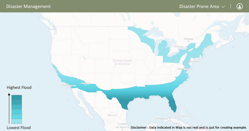
Disaster Prone Area :
The first and the foremost task of Disaster management is to identify the disaster prone areas of a country.
With the help of GIS, Managers can Identify the areas which are likely to be affected by any disaster, this can be based on the previous data .
Planning safety measures :
The another responsibility of the Disaster management is to take the safety measures and making people aware of these measures. Disaster management department plans the safety measures with the help of maps or any GIS tool in the following way :
Creation of the maps for different disasters : As we know we can create the personalized maps, so you can use any GIS tool to create different maps for the different regions according to the nature of the disaster.
Planning the pre disaster things : Pre disaster thing like identifying number of construction site and the safety measures are identified on the basis of the past data by locating on the maps, and by researching the areas where adversity is highly likely to happen.
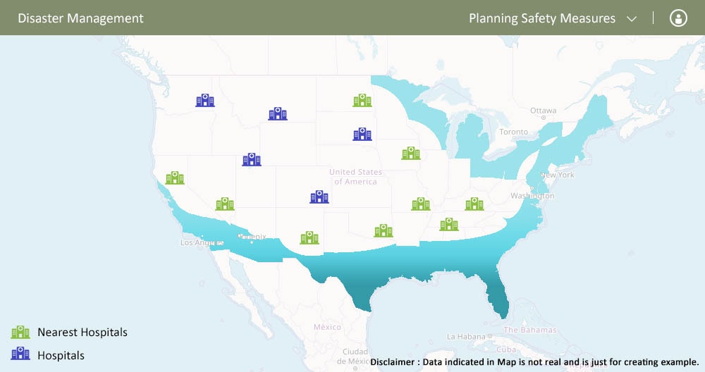
Identifying the medicals and hospitals for treatment nearby : One can identify the nearby hospitals for the treatment of the victims.
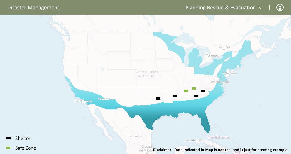
Planning rescue and evacuation :
Disaster management plans the rescue and evacuation of the people, who get stuck in the calamity. GIS helps in planning the evacuation and rescue route, whether it should be by road, by water or by air whichever will be the safest.
GIS will help to Find out the alternate ways to shelters,camps one can easily look for the nearby places where shelters and camps can be organized with the help of map.
Rehabilitation and post disaster management :
Disaster management sector make plans for the rehabilitation of the place and people post the occurrence of the disaster.
GIS will help Identifying the safe location for rehabilitation that are locations as well as zones for the rehabilitation of the victims nearby the affected place. for getting the mapping of the whole affected area we will be using GIS in Disaster Management.
How GIS helps in performing the primary functions :-
GIS is a geographical information system which gives the geographical information to the consumers. so now that we have been through the primary functions of the disaster management sector, and how they use GIS in Disaster Management for performing their function.
So GIS helps them to identify the areas which are disaster prone, How they can plan the rescue and evacuation of the affected people in any area. How to rehabilitate the area and region and managing the post disaster conditions. Thereafter, they also take the safety measures in order to prevent the highly effected area and people. As we know that ‘Precaution is always better than cure’.
So, This is how Disaster Management is using GIS for performing their tasks more efficiently. Using GIS in Disaster Management is one of the best method to have some control over the calamities. Do let us know how this Article is helpful for you, by commenting below in the comment box.
In this post we are going to discuss about Business Continuity Planning and GIS solutions in it. GIS stands for geographic information system. GIS is more than just providing locations and navigation. Though these are the basic functions of the GIS, but these basic functions has more user than just an individual. There are many entities which now are using the GIS for their business purpose. One of them is Business Continuity Planning (BCP). BCP is one of the planning part performed by the industries. BCP is the abbreviation for the term business continuity plan. So lets discuss what is BCP? and how it is useful for the industries? and how do they plan it with the help of GIS?
What Business Continuity Planning is ?
Basically, the main function of Business Continuity Planning is to make sure that the business is functioning in every adverse condition. As the name implies BCP is a plan made for the continuation of the business workings even when it is not possible to continue with the working. Sometimes it so happens that the conditions are not favorable because of any natural calamity has had happened like flood,earthquake, cyclone or maybe some terrorist activities has been noticed, so in these situation no industry can do the efficient working or least to continue the workings. So in these cases BCP plays a major for the industries.
How Business Continuity Planning Works?
Now that we know the functions of the Business Continuity Planning, lets check how it works. So Basically, The main parts of the BCP are :
Planning the alternative site for office.
Plan the resources for working there.
Making a plan with feasibility.
So BCP is not only about the alternative site, but there is more to it. For Business Continuity Planning we need to analyze the kind of calamities or any such adverse situations which may occur in the region where main office is located. so to find out those regions GIS will help industries.
How GIS can help ?
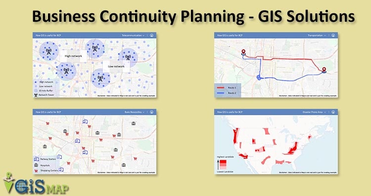
GIS helps industries to evaluate the factors determining the Business Continuity Planning location. These factors are :
Disaster prone areas
Transportation
Telecommunication
Resources
Basic necessities
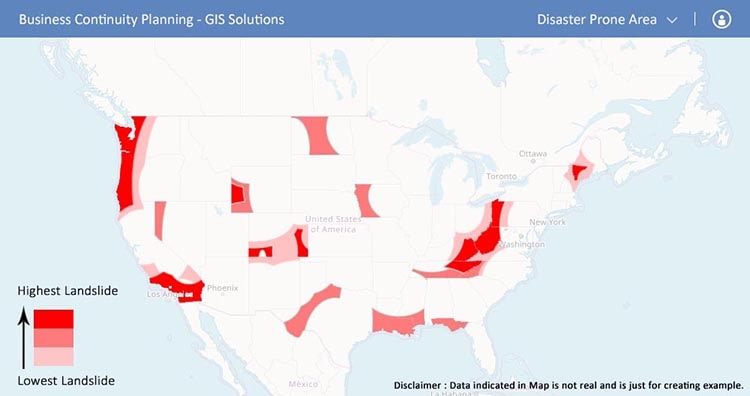
Disaster Prone Area :
With the help of GIS Industry can know the disaster prone area by using maps for the following purpose –
To know the flood prone area : Through GIS one can know the flood prone area as on map we can easily identify the blue region area. So we can know that what else calamities are likely to happen here in these regions.
To forecast the calamities on the basis of past data : one can forecast the calamities which are probable to occur on the basis of the past data of that region.
Know the landscape area : One can easily know the areas where landscapes are likely to occur like hilly areas.
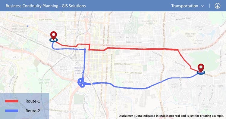
Transportation :
Every Business needs a Good transportation service. Specially when it is a logistics business or the product based business. So while looking for the BCP location of your business, you should take care of the transportation factor also. As far as Transportation is concerned GIS can help you in finding the best routes and can help you in navigating through the route. By using GIS tool or maps you can easily evaluate this factor.
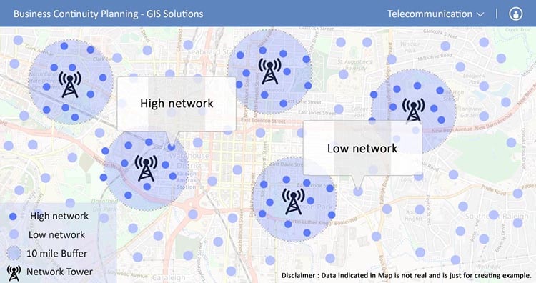
Telecommunication :
Without communication no business can sustain in the market. A business needs to communicate in the market with its vendors. So, While planning the Business Continuity Planning the company needs to check the Network availability and the ways in which communications can be done. So, using the GIS they can find locate the areas where there are chances of having the good networks even if any adversity has occur.
Resources:
Availability of the resources should be an ease. So while looking for the BCP location of your business you need to research the places where you can have the easy access to the resources and then you can locate that in a map.
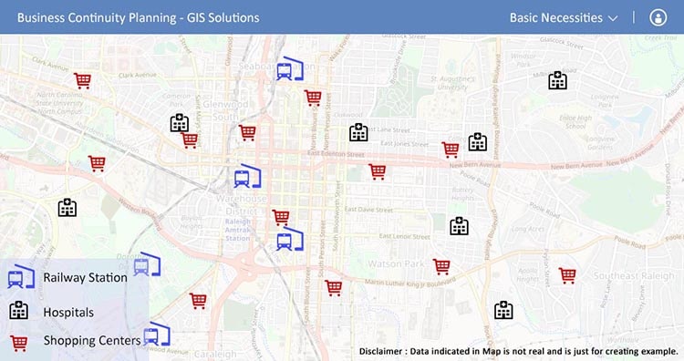
Basic Necessities :
Basic necessities may include hospitals, shopping marts, etc all should be in access such that it would motivate employees to work on the Business Continuity Planning locations. GIS or Maps would be a great help in this.
Instead of all these ways, one can also take the past data which shows when and where such situations had occurred and can locate them easily on the map, which will help them to plan their BCP accordingly.
So, this is how GIS helps in Business Continuity Planning of the company. Do plan BCP for your company and do let us know how this article helped you in making the BCP of your company, by commenting below in the comment box.
GIS (Geographic information system) is a tool to get Geo spatial information related to any sector. GIS is helping people out here every now and then. People are using GIS to get through the route problems, for finding the locations, and also for making important decision. Curious to know how GIS helps in making the Important decisions? Well!! You are looking for a new place to move in ? okay in that case GIS can help you out by showing the location nearby places and what not. GIS is being used in many Sectors and fields. 16 GIS Uses for different purpose is described below:
Areas of GIS uses :
Okay so you are from agriculture or a government official or a business man ?? No matter who you are GIS will help you, be it –
Telecom sector
medical sector
Agriculture sector
Banking Sector
Insurance Sector
Logistics
Travels & tourism
Disaster Management
Traffic
BCP (Business continuation plan)
Crime Mapping
Education
Economic Development
Infrastructure Development
Advertisement.
GIS Uses and Application – 16 Different Industries Covered
Now that we have already sorted the sectors where we can use GIS ,lets check how GIS can be useful for these sectors.
1.Telecom Sector: GIS uses
Telecom sector is one of the vast sector which requires to get the details of all the regions to provide services to the people in each corner of the country. Telecom sector faces many problems which can be easily solved with the help of GIS.
The problems which are faced by Telecom sectors are :
Capacity Planning: The main problem for the telecom sector is the planning of capacity. Capacity here refers to the capacity of network providing , which are the areas where we need to establish more network services. So for establishing network services in those areas they need some resources
So all these things can be easily found out with the help of GIS maps.
Market Segmentation: Market segmentation states that its a concept to understand the customers and the use of the product by these customers, and specially to understand the market that needs to be target.
Real – time knowledge of Network Structure : Telecom service providers can easily access to the points from where they provide the network service and how strong or weak the signal is in which area. GIS helps them to analyze the Network structure and status as well.
optimum Use of Resources: GIS system helps the companies to utilize their resources efficiently and effectively, as GIS gives the information about where what is required ,which helps these companies to invest where it is required. This leads to the efficient use of resources.
Demand Forecasting : Once the company knows about the target market or target customers , it makes so easy for them to forecast the demand.
Telecom – GIS uses and application
2.Hospital Industry: GIS uses and application
Hospital industry is the need of today’s era, this is the only industry which is helping us to come out of any severe disease or it helps us whenever we need, they do not see time to serve us. We reach to them in midnight and they will be ready to serve you. So GIS is helping Hospital industry to serve us better in the following ways :
Identifying health Trends : GIS helps this industry to identify and analyze the health trends , like which are the areas that can get affected with any particular disease,which are the areas where cancer patients are more and so on.
Tracking the disease spread: GIS helps this industry to look over the spread a disease can cause. How much harmful a disease spread would be.
Hospital – GIS uses and application
Improved Services : GIS helps this industry to grow by providing best services. The services of this industry can be improved on a regular basis with the help of GIS. As GIS would let them know about which are the disease prone area, where what kind of disease can occur.
3.Agriculture: GIS application
Agriculture is the main source of income in many families ,with Agriculture we get our two meals for a day, and it is very essential sector for any economy. We use agricultural products regularly,but have you ever seen a question crossing your mind that how does the agricultural products are produced ? So, there are few factors which can effect the Agriculture tremendously if not considered correct way . They are :
Know Land Type: GIS helps you in looking for the type of land whether it is fertile or non fertile. Fertile land is used for agriculture purpose while non fertile is not usable or agriculture purpose.
Weather Prone Area: GIS helps to locate the weather prone areas which can help the people to plan their agriculture process accordingly.
Drought : GIS helps people to identify the area facing drought such that they can provide the crops to these areas.
Water supply: water plays a major role in planning for agriculture as to we need water for irrigating the crops and that water should be poured to it in the right amount and it should be absorbed by the soil instead of leaking out of farms.
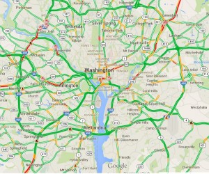
4.Traffic : GIS uses and application
Traffic is such an irresistible thing which has power to irritate us ,to frustrate us and what not?? How great would that be to know the live traffic while leaving from home or office such that you can avoid that congestion?
Know live Congestion or future traffic on Google map
You may also check how Google Map can be used for knowing real time traffic and predicting in future.
GIS can help you out with this problem as it can provide you the traffic updates using Real – Time data . Moreover, you can also predict the future traffic situations with the help of GIS. What else do you want?. So avoid the traffic and reach anywhere on time.
5. Economic Development : GIS uses and application
Economic development can be done using GIS. Basically, Economic development refers to the growth of economies of a country, which can be majorly effected by the business. So, Economic development is looking for the people to plan a business and invest money in it. But the question arises is how GIS can help in economic development?
The answer to this question is that GIS helps in identifying the locations and areas with all the attributes which can make a business grow with a fast or steady pace, GIS will find the best location for you, where you can plan a business and it will help you out with the business growth opportunities as well.
6.Insurance Sector: GIS uses
Insurance Sector is one of the prime sector which is indulged in the all sort of the sectors and individual as well. We all buy insurance policies for our own,for our vehicles,for our mobile phones or for any of our asset. We find insurance a very attractive thing which cover our losses. But have you ever thought that why the claim policies differs from one region to another.
Insurance – GIS uses and application
The reason for such differences occurs because of many factors out of which geographic conditions plays a major role. So, Insurance sector is highly driven by GIS .GIS helps this sector for following purpose :
Disaster Prone Regions: With the help of GIS ,Insurance providers assess the areas which are more disaster prone and what are the things which can be followed as to serve their clients.
Risk assessment: Risk assessment is a major part of the insurance policies. People who provides insurance firstly assess the risk.They assess how much risk is included in any region and they make policies according to their assessment of risk.
Claim management: Claim management is followed by the risk assessment and Risk management done with the help of GIS.
Decision making tool: GIS works as a Decision making tool for the Insurance sector. They People use GIS for making decisions as to where to provide insurance and where to not. If providing it to any one then what should be the claim amount and so on.
7.Banking Sector: GIS application and Use
Banking sector helps in the proper flow of the money. Basically banking sector provides services for depositing money , providing loans, withdrawing money and what not. So basically the thing is to maintain the cash outflow and inflow in the bank and outer economy also.
Now days Banks are also into other activities and providing other services as well to generate the profits and making the customers look for more opportunities. So,all these activities becomes much easier with the help of the GIS.
GIS help Banks to maintain a good database of the customers. With the help of GIS,Banks can easily do the following process:
Customer Database : GIS helps banks to maintain and visualize the data of customers as they will know from where we have the more customer,how many customers are from which region and belongs to which age group
Market Analysis: Banks do analysis of the market trends and allow the people from different area and regions to bank with them.
Focused Marketing: Focused marketing can be done very easily as banks can do the market analysis with the help of GIS. This Analysis can make Banks do marketing for the focused areas,regions,people.
Better Services: GIS make Banks to serve best to their customer as to they can know the area where customer needs to be focused.
8.Logistics: GIS uses
Logistics, in a layman language we can call it as transportation. We all use transportation for moving our luggage,our vehicles and for many things. So, lets check how GIS can be useful for the Logistic service providers:
Tracking – GIS uses and application
Navigation : GIS can help the Logistic service providers in navigating from one place to another,showing them routes and the shortest and the best route to reach their destination.
Cost Reduction: GIS helps in navigating and reducing cost also, GIS will make the route and will show the routes out of which you can choose any one whichever you find most suitable.
Tracking : Logistics service providers and the customers can also track their orders with the help of GIS.
9.Disaster Management: GIS application and Uses
In every country there is a separate department for Disaster Management. This department is specially organized for looking over the Disaster and how to manage those disaster if any occurs.
Disaster Management – GIS uses and application
This department take very good care of all the disaster related things with the help of GIS , in the following way:
Disaster Prone Area: The main and primary function of the Disaster management department is to identify the areas where disaster is more likely to occur. Disaster can be earthquake or flood or any miss happening .
Planning of Rescue and evacuation: They identify the disaster prone areas with the help of GIS, that helps them to look for the rescue and evacuation. They plan how to rescue and evacuate the people from that disaster prone areas, what would be the procedure.
No construction Site : This department makes sure that no construction site is established in these disaster prone areas.
Rehabiliation and post disaster Management: Another main role performed by this department is the rehabiliation of the place and the people which has been effected because of the disaster. They make sure the situation comes back to normal as soon as possible.
10.Education Sector: GIS uses
Education is the basic necessity of the people now days,Education allow us to grow,explore, and it helps us to make a difference in the society. GIS is also giving something to education sector also.
Degree : GIS is now allowing students to earn a degree in GIS . We know the course as Geo Spatial. Many universities are providing Geo spatial courses to its students.
Difference in education system: Students are now looking for the different sectors to make their career in. Students are not looking for the same regular courses rather they are looking for something which would be different than the trending courses as well as should have good opportunities to grow and explore more. GIS is fulfilling this requirement with utmost efficiency which is definitely making a difference in our education system.
11.Travels and tourism : GIS uses and application
Travels and tourism is one of the growing business in today’s era. Travels and tourism sector is highly using GIS to show visualized places to their customers. We all approach to travels and tourism companies to provide us a package tour whenever we go to spend our vacations to a new place. Lets have a look on how Travels and Tourism business holders uses GIS :
Travel – GIS uses and application
Visualization of tourist spot: GIS helps the customers and business as well to visualize all the tourist spot which helps business to attract customers by actually giving them visualized view of the spots, which they would be visiting.
Tourist location: GIS helps them to visualize location where they can visit.
Route planning : GIS helps in the route planning also.
Accommodation : GIS will help you to get the best accommodation facility.
Cultural Events and Special attraction : For looking up to Cultural events and special attraction of any particular area GIS will be very Helpful.
12. BCP (Business continuation plan) : GIS application and uses
BCP or business continuation plan is one of the plan which businesses are implementing in their business. Business continuation plan is one of the way to keep our business working unaffected in adverse conditions. Adverse conditions could be any natural disaster or a human made like terrorist attack. This plan helps in continuation of business working . So to plan BCP business take help of GIS for :
Damage Assessment and Repair during Emergencies: GIS is helping to plan BCP by the assessment of the damage that can happen and how to cover up those damages in emergencies.
Evacuation: Evacuation for any damage has to be a planned in prior . With the help of GIS we can make the route for evacuating people out of the affected area.
Office Relocation : At the time of adversities , there might be chances that we need to relocate our office, until everything gets back to normal. With the help of GIS we can get the appropriate location for relocating the office.
SCM : SCM or supply chain management is one of the key factor for any business , specially for product providers. They need to supply their products further to its end users. GIS is required to Plan SCM in adversities.
Threat Assessment : GIS helps business to assess the threat level before establishing any business in any area, and also for the BCP they assess the level of threat.
Weather Mapping: GIS helps in mapping the weather for any location. GIS can help you the best to know weather conditions,for your office location.
13. Infrastructure Development : GIS application
GIS is continuously contributing in the development of the society. So now GIS is also contributing in the Development of Infrastructure. Lets see How GIS is helping in the development of the Infrastructure:
Real Estate – GIS uses and application
Transportation: GIS is helping in the development of transportation facilities as we all know that our success is highly depends on infrastructure development. So, in lieu to it every sector has to be developed.
Communication : Communication is the way of conveying our thoughts to other person. So GIS is providing ,the Communication service providers to visualize the network availability in the area.
Facilities and amenities : GIS helps to develop infrastructure of the country or society by providing the data of facilities and amenities available in which area , which are the areas lacking behind in terms of facilities and amenities, and also to get the data of the facilities and amenities which are provided.
Real Estate:
14. Crime Mapping : GIS uses and application
Today Crime is increasing day by day , people are being unsympathetic to others. Crime has taken a big toll irrespective of the place, be it a small village or a metro city . People are committing crime to satisfy their ego, to get their work done with a fear and so on. It gets very much difficult to investigate about the crime, people involved , place where it has been done and what not. So we have a solution for all these problems as the Investigating team use GIS for solving any case. Lets see how this team can use GIS for their professional needs:
Helps in Law Enforcement : GIS can help in enforcing law to the regions according to the crime committed in the area.
Display Spatial Patterns of events : GIS helps in visualizing the type or pattern of crime committed in different areas.
Investigating Serial Offense : GIS helps in investigating serial offense as we can reach to the culprit by tracking his location.
15. Advertising Industry : GIS application
In 21st century , marketing and advertising plays a major role in making a business famous and approachable to the people. But we need to understand the areas where we have to advertise or in other words we have to prioritize the users. We should know who are the people going to use your product. GIS can help in this task very easily. Advertising companies use GIS for following :
Advertising – GIS uses and application
Market Segmentation : Market segmentation is a process of identifying and dividing the market according to the usage of the product. We can divide the market by age,gender, regions as to identify the people for whom the product is useful and to know the usefulness of the product on map.
Target Market : Once the market segmentation is done, we need to target the market. GIS can help us to Visualize the customers from the segmented market.
16. 3D Campus Mapping : GISUses and application
3D campus mapping is the another use of GIS. GIS helps in making the 3D map for campus. These maps are easier to use and way more convenient than other Maps. 3D maps are useful as they provide better understanding of the campus and the building. It makes so easy to find out the locations with the most efficiency. For all these we need GIS to make the 3D map for a campus.
3D campus Map- GIS uses and application
we have gone through all the sectors where GIS can be used or implemented.So use GIS to advertise your product , to attract customers for your tours and travel business and for what not. If any other sector is here , where we can use GIS, do let us know by commenting below in the comment box.