Download Oklahoma State GIS Maps – Boundary, Counties, Rail, highway

GIS Data and Maps of Oklahoma State is used by planners and surveyors for visualizing and identifying the patterns that are difficult to examine when data is in table form. Here you can download the GIS data of the state boundary, county division, rail and highway maps in just a few clicks. You can use these data for analysis in MAPOG itself or download them in any suitable GIS format. You can download these data in KML, GeoJSON, CSV or Shapefile formats.

Note:

  • All data available are in GCS datum EPSG:4326 WGS84 CRS (Coordinate Reference System).
  • You need to login for downloading the shapefile.

Download Shapefile Data of Oklahoma

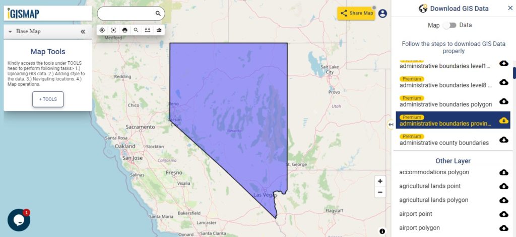
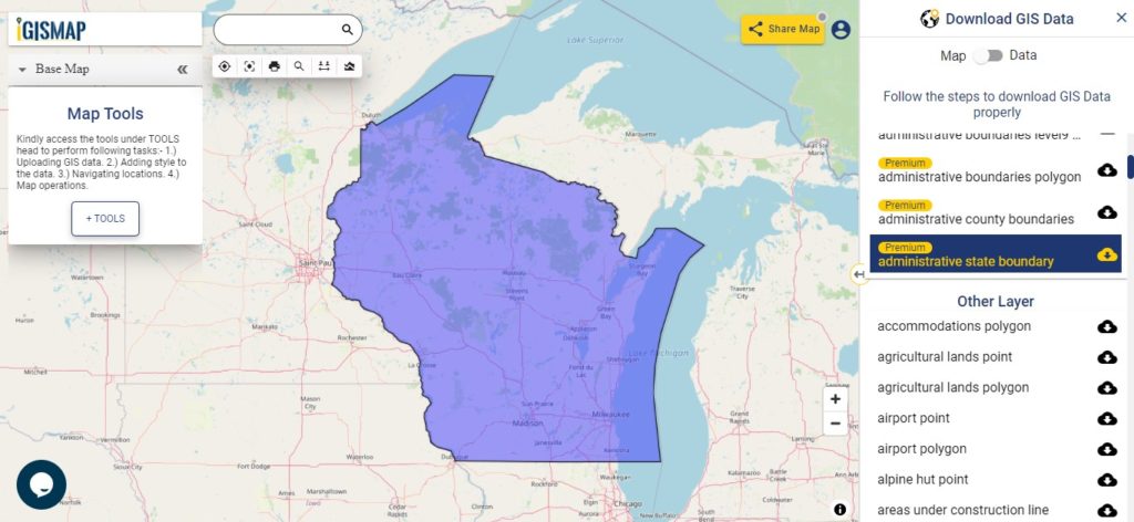
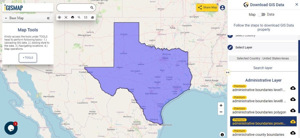
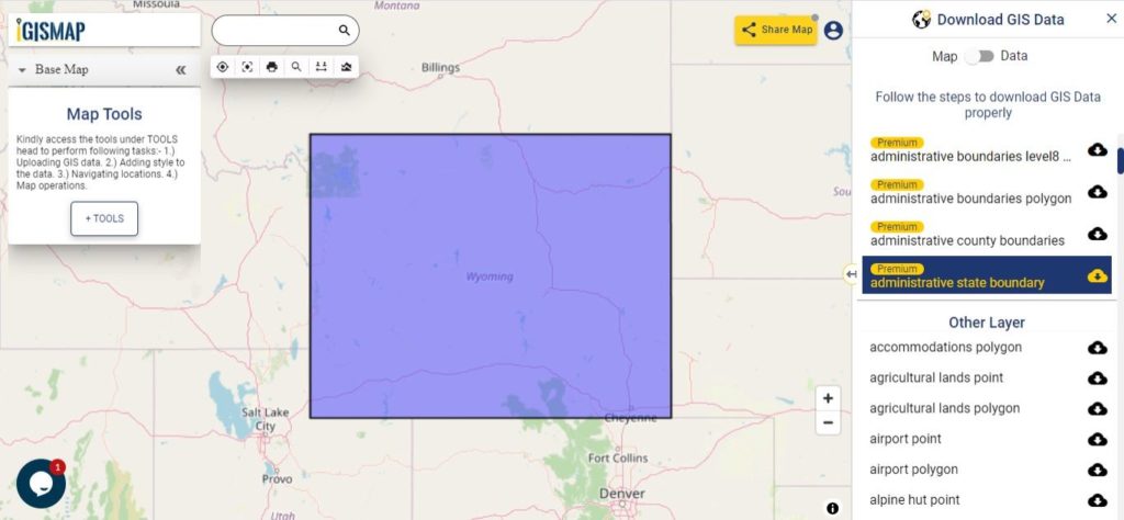
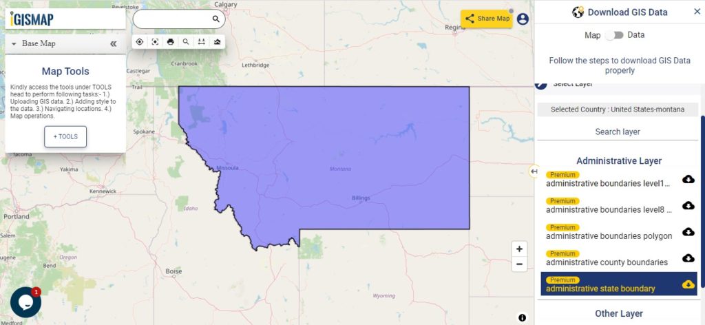
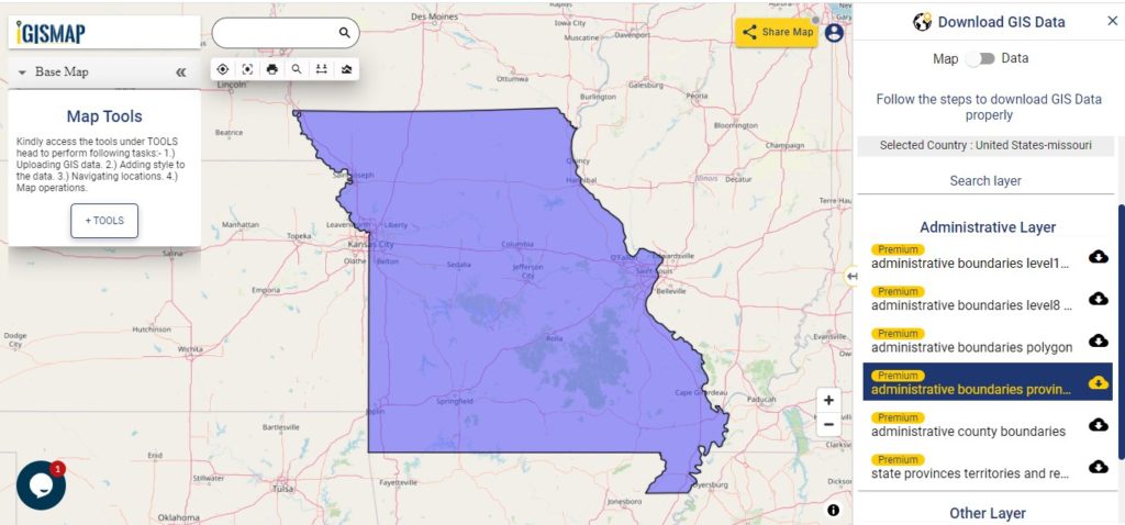
Oklahoma is a state in the South Central region of the United States,[27] bordered by Texas on the south and west, Kansas on the north, Missouri on the northeast, Arkansas on the east, New Mexico on the west, and Colorado on the northwest. Partially in the western extreme of the Upland South, it is the 20th-most extensive and the 28th-most populous of the 50 United States.

Oklahoma State Boundary

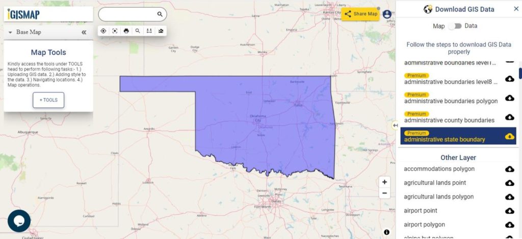
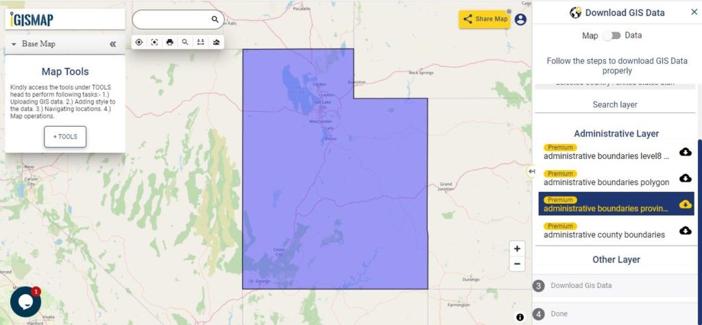
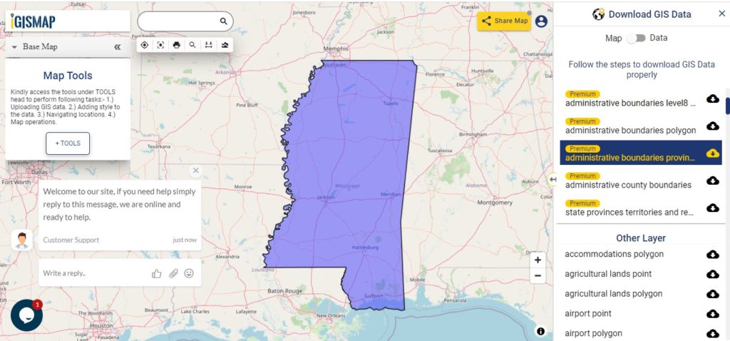
Download Oklahoma State Outline Boundary Shapefile

Download Pennsylvania Counties Shapefile Data

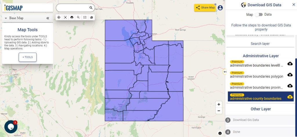
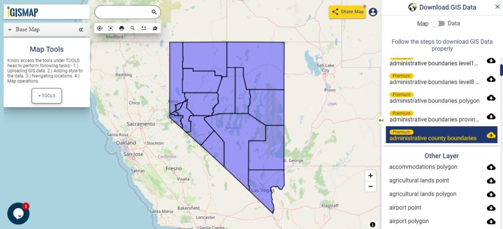
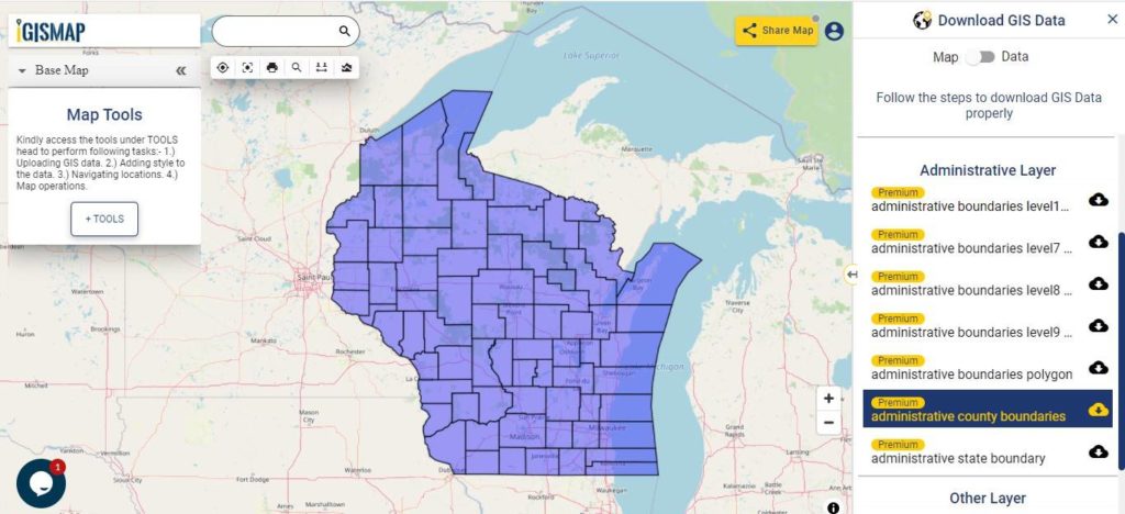
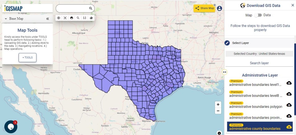
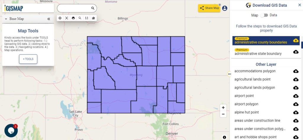
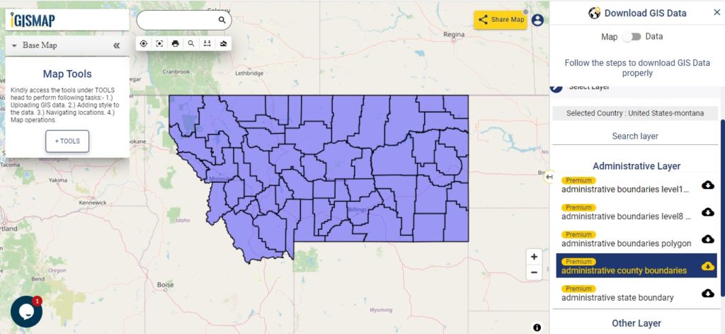
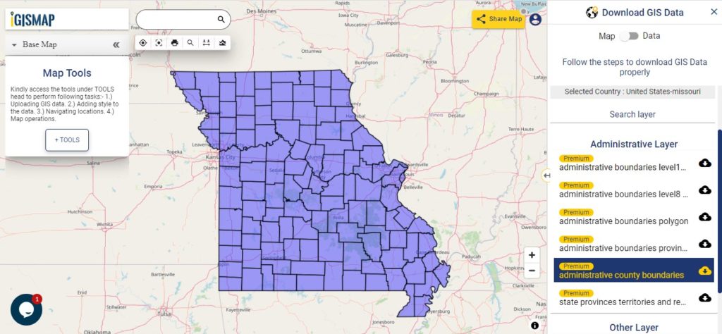
There are 88 counties in the U.S. state of Oklahoma. For a polygon map click on the link given below.

Oklahoma County Boundaries

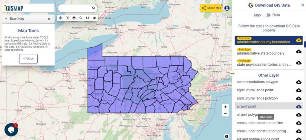
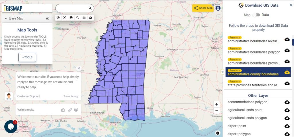
Download Oklahoma County Boundaries Shapefile

Polygon map with county division is visible on the above screen. You can easily download and upload in a tool for free and create a map from GIS data, edit the format, add attribute column and share it with your colleagues

Above layer cover the boundary feature of the following counties

1. Adair County, Stilwell
2. Alfalfa County, Cherokee
3. Atoka County, Atoka
4. Beaver County, Beaver
5. Beckham County, Sayre
6. Blaine County, Watonga
7. Bryan County, Durant
8. Caddo County, Anadarko
9. Canadian County, El Reno
10. Carter County, Ardmore
11. Cherokee County, Tahlequah
12. Choctaw County, Hugo
13. Cimarron County, Boise City
14. Cleveland County, Norman
15. Coal County, Coalgate
16. Comanche County, Lawton
17. Cotton County, Walters
18. Craig County, Vinita
19. Creek County, Sapulpa
20. Custer County, Arapaho
21. Delaware County, Jay
22. Dewey County, Taloga
23. Ellis County, Arnett
24. Garfield County, Enid
25. Garvin County, Pauls Valley
26. Grady County, Chickasha
27. Grant County, Medford
28. Greer County, Mangum
29. Harmon County, Hollis
30. Harper County, Buffalo
31. Haskell County, Stigler
32. Hughes County, Holdenville
33. Jackson County, Altus
34. Jefferson County, Waurika
35. Johnston County, Tishomingo
36. Kay County, Newkirk
37. Kingfisher County, Kingfisher
38. Kiowa County, Hobart
39. Latimer County, Wilburton
40. Le Flore County, Poteau
41. Lincoln County, Chandler
42. Logan County, Guthrie
43. Love County, Marietta
44. Major County, Fairview
45. Marshall County, Madill
46. Mayes County, Pryor
47. McClain County, Purcell
48. McCurtain County, Idabel
49. McIntosh County, Eufaula
50. Murray County, Sulphur
51. Muskogee County, Muskogee
52. Noble County, Perry
53. Nowata County, Nowata
54. Okfuskee County, Okemah
55. Oklahoma County, Oklahoma City
56. Okmulgee County, Okmulgee
57. Osage County, Pawhuska
58. Ottawa County, Miami
59. Pawnee County, Pawnee
60. Payne County, Stillwater
61. Pittsburg County, McAlester
62. Pontotoc County, Ada
63. Pottawatomie County, Shawnee
64. Pushmataha County, Antlers
65. Roger Mills County, Cheyenne
66. Rogers County, Claremore
67. Seminole County, Wewoka
68. Sequoyah County, Sallisaw
69. Stephens County, Duncan
70. Texas County, Guymon
71. Tillman County, Frederick
72. Tulsa County, Tulsa
73. Wagoner County, Wagoner
74. Washington County, Bartlesville
75. Washita County, Cordell
76. Woods County, Alva
77. Woodward County, Woodward

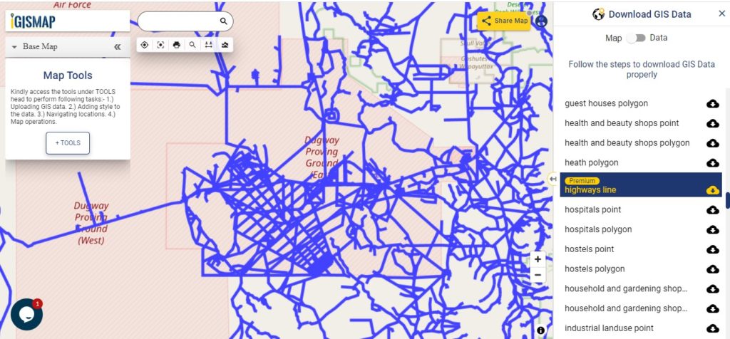
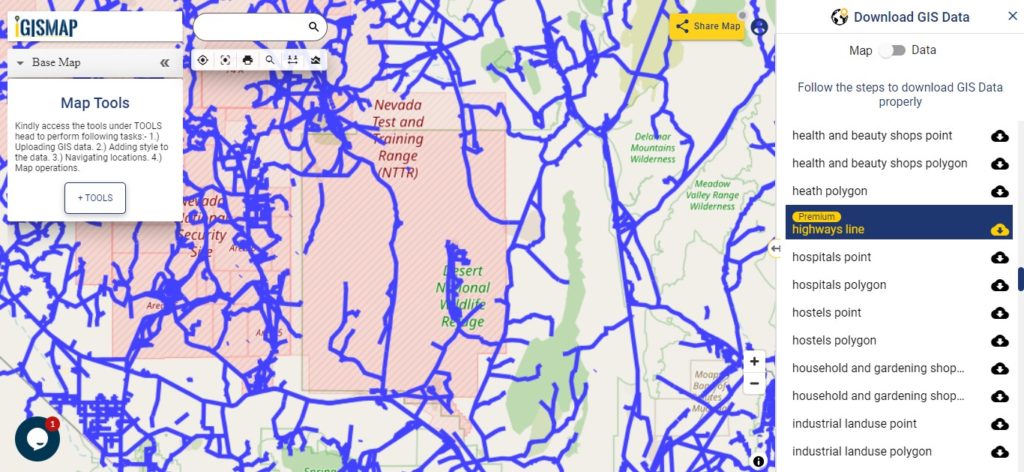
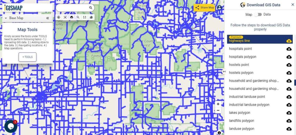
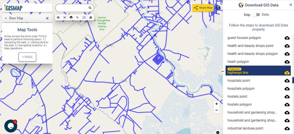
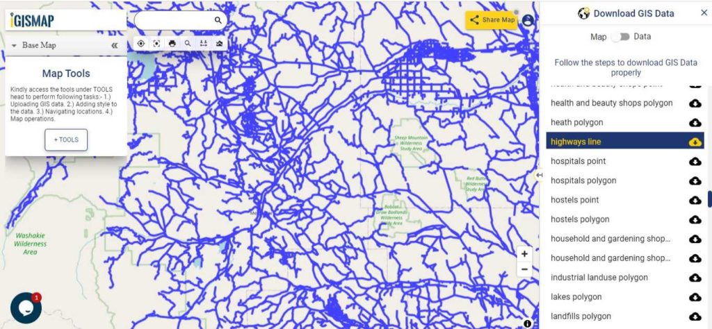
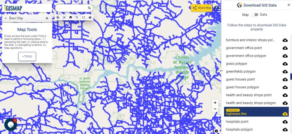
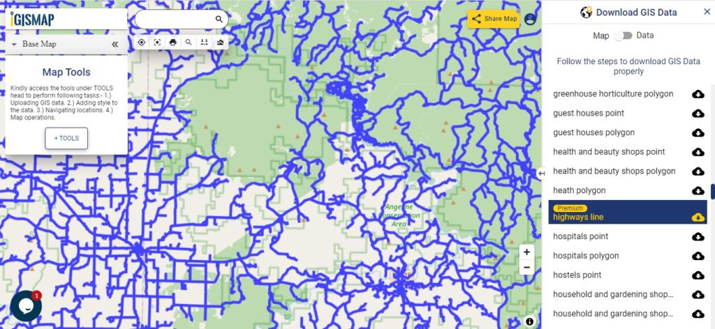
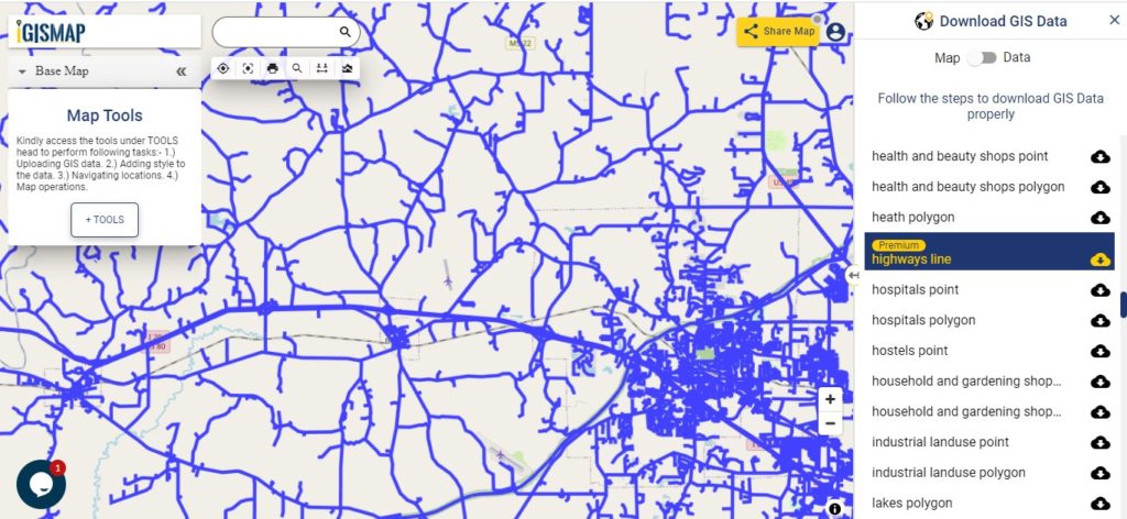
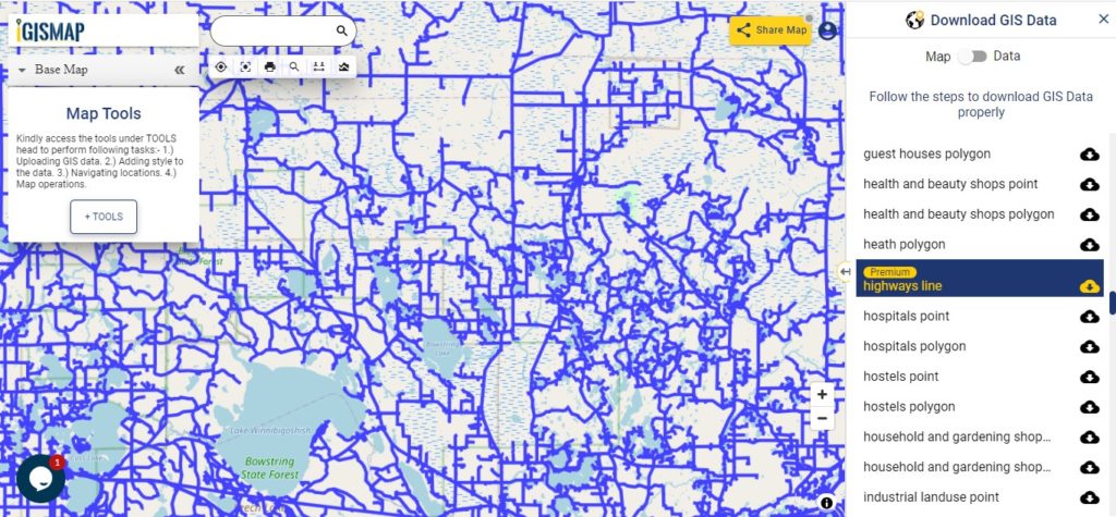
Highway Line GIS Maps of Oklahoma State

Oklahoma Highway Lines

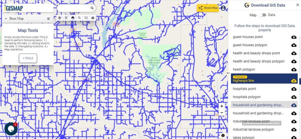
Download Oklahoma Highway Lines Shapefile

In the above map, zoom in view of highway line map is shown. Similarly, you can easily download point based GIS data of airport locations, ATM locations, parking locations, hospital location, etc.

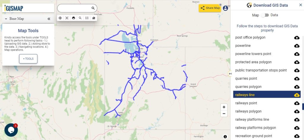
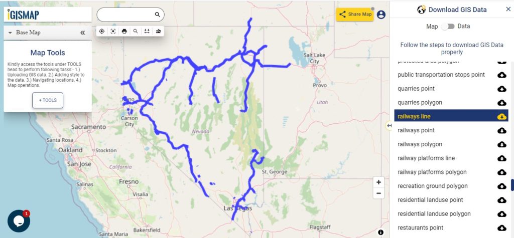
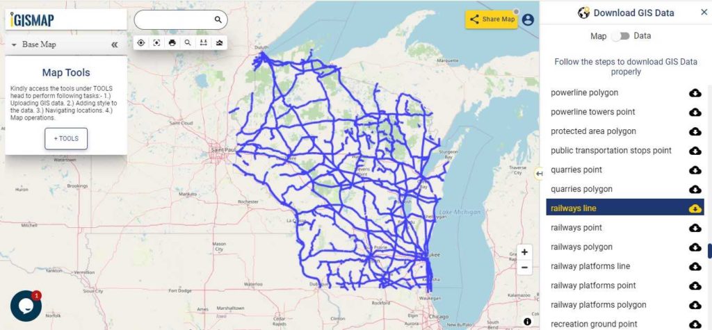
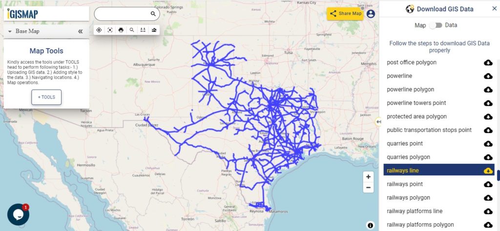
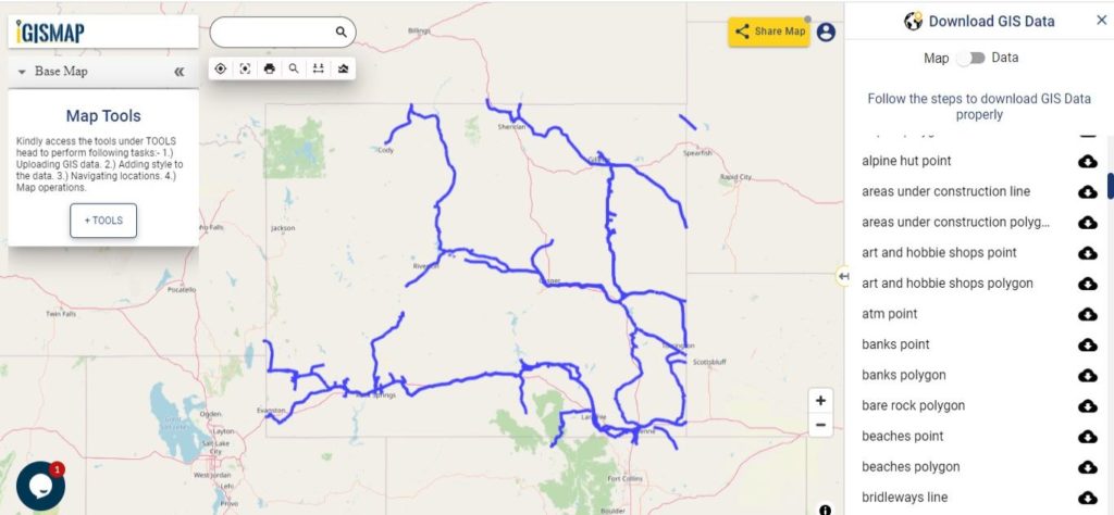
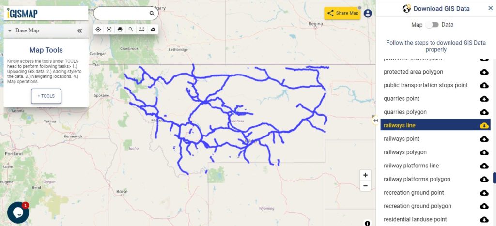
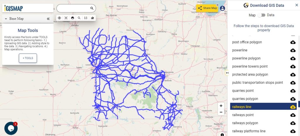
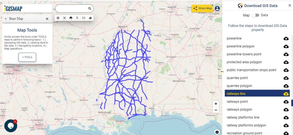
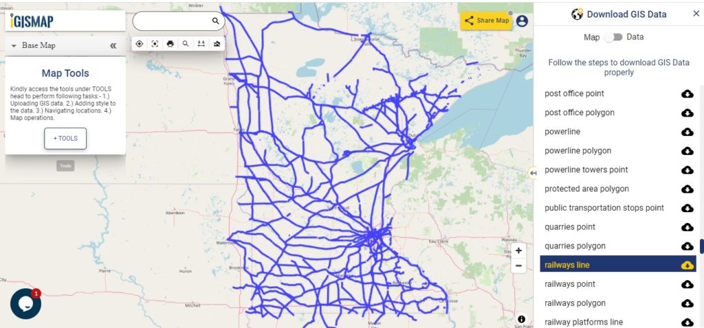
Railways Line GIS Data of Oklahoma State

Oklahoma Railway Lines

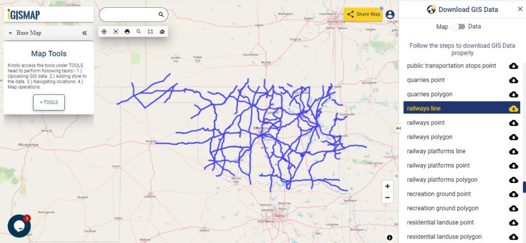
Download Oklahoma Railway Lines Shapefile

In the above screen railways line map is shown. Likewise, you can download residential land use point, polygon, restaurants, business GIS data layers.

Download GIS Data of other states of USA:

  1. Alabama
  2. Alaska
  3. Arizona
  4. Arkansas
  5. California
  6. Colorado
  7. Connecticut
  8. Florida
  9. Georgia
  10. Hawaii
  11. Idaho
  12. Illinois
  13. Indiana
  14. Iowa
  15. Kansas
  16. Massachusetts
  17. Maryland
  18. Michigan
  19. Minnesota
  20. Mississipi
  21. Missouri
  22. Montana
  23. Nevada
  24. Nebraska
  25. Ohio
  26. Oklahoma
  27. Pennsylvania
  28. Utah
  29. Vermont
  30. Washington
  31. Wisconsin
  32. Wyoming
  33. Tennessee
  34. Texas
  35. Kentucky
  36. Louisiana
  37. Maine
  38. North Carolina
  39. Oregon
  40. Virginia
  41. West Virginia

Disclaimer : If you find any shapefile data of country provided is in correct do contact us or comment below, so that we will correct the same in our system.

Download Utah State GIS Maps – Boundary, Counties, Rail, highway

GIS Data and Maps of Utah State is used by planners and surveyors for visualizing and identifying the patterns that are difficult to examine when data is in table form. Here you can download the GIS data of the state boundary, county division, rail and highway maps in just a few clicks. You can use these data for analysis in IGISMAP itself or download them in any suitable GIS format. You can download these data in KML, GeoJSON, CSV or Shapefile formats.

Note:

  • All data available are in GCS datum EPSG:4326 WGS84 CRS (Coordinate Reference System).
  • You need to login for downloading the shapefile.

Download Shapefile Data of Utha State

Utah is a state in the Mountain West region of the United States. Salt Lake city is the capital city of the state. In addition, if you are looking for any other GIS formats then use Gis File Converter.

Utah Sate Boundary

Download Utah State Outline Boundary Shapefile

In the above screen boundary map of Utah state. This is the map view for the data table switch button from the map to the data. The layer name is provided on the right side of the screen. For download click on the button placed beside the map layer name. You can locate your store/ shop on a map.

Download Utah Counties Shapefile Data

There are 29 counties in the U.S. state of Utah.

Utah County Boundary

Download Utah County Boundary Shapefile

Polygon map with county division is visible on the above screen. You can easily download and upload in a tool for free and create a map from GIS data. Edit, format, add attribute column and share it with your colleagues.

Above all Layers cover GIS data of following Counties –

Beaver
Box Elder
Cache
Carbon
Daggett
Davis
Duchesne
Emery
Garfield
Grand
Iron
Juab
Kane
Millard
Morgan
Piute
Rich
Salt Lake
San Juan
Sanpete
Sevier
Summit
Tooele
Uintah
Utah
Wasatch
Washington
Wayne
Weber

Highway Line GIS Data of U.S. Utah State

Utah Highway Lines

Download Utah Highway Line Shapefile

Zoom in view of highway line map is shown shown above. Similarly, you can easily download point based GIS data of airport point, ATM point, parking area, hospital location, etc.

Railways Line GIS Data of Utah U.S. State

Utah Railway Lines

Download Utah Railway Line Shapefile

In the above screen railways line map is shown. Likewise, you can download residential land use point, polygon, restaurants, business gis data layers.

Download GIS Data of other states of USA:

  1. Alabama
  2. Alaska
  3. Arizona
  4. Arkansas
  5. California
  6. Colorado
  7. Connecticut
  8. Florida
  9. Georgia
  10. Hawaii
  11. Idaho
  12. Illinois
  13. Indiana
  14. Iowa
  15. Kansas
  16. Massachusetts
  17. Maryland
  18. Michigan
  19. Minnesota
  20. Mississipi
  21. Missouri
  22. Montana
  23. Nevada
  24. Nebraska
  25. Ohio
  26. Oklahoma
  27. Pennsylvania
  28. Utah
  29. Vermont
  30. Washington
  31. Wisconsin
  32. Wyoming
  33. Tennessee
  34. Texas
  35. Kentucky
  36. Louisiana
  37. Maine
  38. North Carolina
  39. Oregon
  40. Virginia
  41. West Virginia

Disclaimer : If you find any shapefile data of country provided is in correct do contact us or comment below, so that we will correct the same in our system.

Download Nevada State GIS Maps – Boundary, Counties, Rail, highway

GIS Data and Maps of Nevada State is used by planners and surveyors for visualizing and identifying the patterns that are difficult to examine when data is in table form. Here you can download the GIS data of the state boundary, county division, rail and highway maps in just a few clicks. You can use these data for analysis in MAPOG itself or download them in any suitable GIS format. You can download these data in KML, GeoJSON, CSV or Shapefile formats.

Note:

  • All data available are in GCS datum EPSG:4326 WGS84 CRS (Coordinate Reference System).
  • You need to login for downloading the shapefile.

Download Shapefile Data of Nevada State

Nevada is a state in the Western United States. Carson city is the capital city of the state. State is also popular for its luxurious casinos in city of Las Vega In addition, if you are looking for any other GIS formats then use GIS File Converter.

Nevada State Boundary

Download Nevada State Outline Boundary Shapefile

In the above screen boundary map of Nevada state. This is the map view for the data table switch button from the map to the data. The layer name is provided on the right side of the screen. For download click on the button placed beside the map layer name. You can locate your store/ shop on a map.

Download Nevada Counties Shapefile Data

There are 16 counties and 1 independent city in the U.S. state of Nevada.

Nevada County Boundary

Download Nevada County Boundary Shapefile

Polygon map with county division is visible on the above screen. You can easily download and upload in a tool for free and create a map from GIS data. Edit, format, add attribute column and share it with your colleagues.

Above all Layers cover GIS data of following Counties –

  • Churchill County
  • Clark County
  • Douglas County
  • Elko County
  • Esmeralda County
  • Eureka County
  • Humboldt County
  • Lander County
  • Lyon County
  • Mineral County
  • Nye County
  • Pershing County
  • Storey County
  • Washoe County

Highway Line GIS Data of U.S. Nevada State

Nevada Highway lines

Download Nevada Highway line Shapefile

Zoom in view of highway line map is shown shown above. Similarly, you can easily download point based GIS data of airport point, ATM point, parking area, hospital location, etc.

Railways Line GIS Data of Nevada U.S. State

Nevada Railway Line

Download Nevada Railway line Shapefile

In the above screen railways line map is shown. Likewise, you can download residential land use point, polygon, restaurants, business GIS data layers.

Download GIS Data of other states of USA:

  1. Alabama
  2. Alaska
  3. Arizona
  4. Arkansas
  5. California
  6. Colorado
  7. Connecticut
  8. Florida
  9. Georgia
  10. Hawaii
  11. Idaho
  12. Illinois
  13. Indiana
  14. Iowa
  15. Kansas
  16. Massachusetts
  17. Maryland
  18. Michigan
  19. Minnesota
  20. Mississipi
  21. Missouri
  22. Montana
  23. Nevada
  24. Nebraska
  25. Ohio
  26. Oklahoma
  27. Pennsylvania
  28. Utah
  29. Vermont
  30. Washington
  31. Wisconsin
  32. Wyoming
  33. Tennessee
  34. Texas
  35. Kentucky
  36. Louisiana
  37. Maine
  38. North Carolina
  39. Oregon
  40. Virginia
  41. West Virginia

Disclaimer : If you find any shapefile data of country provided is in correct do contact us or comment below, so that we will correct the same in our system.

Download Wisconsin State GIS Maps – Boundary, Counties, Rail, highway

GIS Data and Maps of Wisconsin State is used by planners and surveyors for visualizing and identifying the patterns that are difficult to examine when data is in table form. Here you can download the GIS data of the state boundary, county division, rail and highway maps in just a few clicks. You can use these data for analysis in MAPOG itself or download them in any suitable GIS format. You can download these data in KML, GeoJSON, CSV or Shapefile formats.

Note:

  • All data available are in GCS datum EPSG:4326 WGS84 CRS (Coordinate Reference System).
  • You need to login for downloading the shapefile.

Download Shapefile Data of Wisconsin State

Wisconsin is a state in the Upper Midwest region of the United States. Madison city is the capital city of the state. In addition, if you are looking for any other GIS formats then use GIS File Converter.

Wisconsin State Boundary

Download Wisconsin State Outline Boundary Shapefile

In the above screen boundary map of Wisconsin state. This is the map view for the data table switch button from the map to the data. The layer name is provided on the right side of the screen. For download click on the button placed beside the map layer name. You can locate your store/ shop on a map.

Download Wisconsin Counties Shapefile Data

There are 72 counties in the U.S. state of Wisconsin. For a polygon map click on the link given below.

Wisconsin County Boundaries

Download Wisconsin County Boundary Shapefile

Polygon map with county division is visible on the above screen. You can easily download and upload in a tool for free and create a map from GIS data. Edit, format, add attribute column and share it with your colleagues.

Above all Layers cover GIS data of following Counties –

Adams County
Ashland County
Barron County
Bayfield County
Brown County
Buffalo County
Burnett County
Calumet County
Chippewa County
Clark County
Columbia County
Crawford County
Dane County
Dodge County
Door County
Douglas County
Dunn County
Eau Claire County
Florence County
Fond du Lac County
Forest County
Grant County
Green County
Green Lake County
Iowa County
Iron County
Jackson County
Jefferson County
Juneau County

Highway Line Gis Data of Wisconsin State

Wisconsin Highway Lines

Download Wisconsin Highway lineShapefile

Zoom in view of highway line map is shown shown above. Similarly, you can easily download point based GIS data of airport point, ATM point, parking area, hospital location, etc.

Railways Line Gis Data of Wisconsin U.S. State

Wisconsin Railway Lines

Download Wisconsin Railway line Shapefile

In the above screen railways line map is shown. Likewise, you can download residential land use point, polygon, restaurants, business gis data layers.

Download GIS Data of other states of USA:

  1. Alabama
  2. Alaska
  3. Arizona
  4. Arkansas
  5. California
  6. Colorado
  7. Connecticut
  8. Florida
  9. Georgia
  10. Hawaii
  11. Idaho
  12. Illinois
  13. Indiana
  14. Iowa
  15. Kansas
  16. Massachusetts
  17. Maryland
  18. Michigan
  19. Minnesota
  20. Mississipi
  21. Missouri
  22. Montana
  23. Nevada
  24. Nebraska
  25. Ohio
  26. Oklahoma
  27. Pennsylvania
  28. Utah
  29. Vermont
  30. Washington
  31. Wisconsin
  32. Wyoming
  33. Tennessee
  34. Texas
  35. Kentucky
  36. Louisiana
  37. Maine
  38. North Carolina
  39. Oregon
  40. Virginia
  41. West Virginia

Disclaimer : If you find any shapefile data of country provided is in correct do contact us or comment below, so that we will correct the same in our system.

Download Texas State GIS Maps – Boundary, County, rail, highway line

GIS Data and Maps of Texas State is used by planners and surveyors for visualizing and identifying the patterns that are difficult to examine when data is in table form. Here you can download the GIS data of the state boundary, county division, rail and highway maps in just a few clicks. You can use these data for analysis in MAPOG itself or download them in any suitable GIS format. You can download these data in KML, GeoJSON, CSV or Shapefile formats.

Note:

  • All data available are in GCS datum EPSG:4326 WGS84 CRS (Coordinate Reference System).
  • You need to login for downloading the shapefile.

Download Shapefile Data of Texas State

Texas is a state in the South Central Region of the United States. It is the second largest U.S. state by both area and population. Austin is the capital city of the state.

Texas State Boundary

Download Texas State Outline Boundary Shapefile

In the above screen, boundary map of the state is visible. Other gis layers are also available to download for example – administrative boundary level 7, 8,9 arts & hobby shops, etc. For viewing the data table toggle the button from Map to Data shown on the top of the map data on the screen. For download click on the button shown near the layer name. A modal will appear to select the gis format. You can put your business or store location on the map and embed it on your website.

Download Texas Counties Shapefile Data

The U.S. state of Texas is divided into 254 counties, more than any other U.S. state.

Texas County Boundary

Download Texas County Boundary Shapefile

Polygon map with county division is visible on the above screen. You can easily download and upload in a tool for free and create a map from gis data. Edit, format, add attribute column and share it with your colleagues.

Above all GIS data covers following Counties of the state –

  • 001  Anderson County, Palestine, Texas
  • 002  Andrews County, Andrews, Texas
  • 003  Angelina County, Lufkin, Texas
  • 004  Aransas County, Rockport, Texas
  • 005  Archer County, Archer City, Texas
  • 006  Armstrong County, Claude, Texas
  • 007  Atascosa County, Jourdanton, Texas
  • 008  Austin County, Bellville, Texas
  • 009  Bailey County, Muleshoe, Texas
  • 010  Bandera County, Bandera, Texas
  • 011  Bastrop County, Bastrop, Texas
  • 012  Baylor County, Seymour, Texas
  • 013  Bee County, Beeville, Texas
  • 014  Bell County, Belton, Texas
  • 015  Bexar County, San Antonio, Texas
  • 016  Blanco County, Johnson City, Texas
  • 017  Borden County, Gail, Texas
  • 018  Bosque County, Meridian, Texas
  • 019  Bowie County, Boston, Texas
  • 020  Brazoria County, Angleton, Texas
  • 021  Brazos County, Bryan, Texas
  • 022  Brewster County, Alpine, Texas
  • 023  Briscoe County, Silverton, Texas
  • 024  Brooks County, Falfurrias, Texas
  • 025  Brown County, Brownwood, Texas
  • 026  Burleson County, Caldwell, Texas
  • 027  Burnet County, Burnet, Texas
  • 028  Caldwell County, Lockhart, Texas
  • 029  Calhoun County, Port Lavaca, Texas
  • 030  Callahan County, Baird, Texas
  • 031  Cameron County, Brownsville, Texas
  • 032  Camp County, Pittsburg, Texas
  • 033  Carson County, Panhandle, Texas
  • 034  Cass County, Linden, Texas
  • 035  Castro County, Dimmitt, Texas
  • 036  Chambers County, Anahuac, Texas
  • 037  Cherokee County, Rusk, Texas
  • 038  Childress County, Childress, Texas
  • 039  Clay County, Henrietta, Texas
  • 040  Cochran County, Morton, Texas
  • 041  Coke County, Robert Lee, Texas
  • 042  Coleman County, Coleman, Texas
  • 043  Collin County, McKinney, Texas
  • 044  Collingsworth County, Wellington, Texas
  • 045  Colorado County, Columbus, Texas
  • 046  Comal County, New Braunfels, Texas
  • 047  Comanche County, Comanche, Texas
  • 048  Concho County, Paint Rock, Texas
  • 049  Cooke County, Gainesville, Texas
  • 050  Coryell County, Gatesville, Texas
  • 051  Cottle County, Paducah, Texas
  • 052  Crane County, Crane, Texas
  • 053  Crockett County, Ozona, Texas
  • 054  Crosby County, Crosbyton, Texas
  • 055  Culberson County, Van Horn, Texas
  • 056  Dallam County, Dalhart, Texas
  • 057  Dallas County, Dallas, Texas
  • 058  Dawson County, Lamesa, Texas
  • 059  Deaf Smith County, Hereford, Texas
  • 060  Delta County, Cooper, Texas
  • 061  Denton County, Denton, Texas
  • 062  DeWitt County, Cuero, Texas
  • 063  Dickens County, Dickens, Texas
  • 064  Dimmit County, Carrizo Springs, Texas
  • 065  Donley County, Clarendon, Texas
  • 066  Duval County, San Diego, Texas
  • 067  Eastland County, Eastland, Texas
  • 068  Ector County, Odessa, Texas
  • 069  Edwards County, Rocksprings, Texas
  • 070  Ellis County, Waxahachie, Texas
  • 071  El Paso County, El Paso, Texas
  • 072  Erath County, Stephenville, Texas
  • 073  Falls County, Marlin, Texas
  • 074  Fannin County, Bonham, Texas
  • 075  Fayette County, La Grange, Texas
  • 076  Fisher County, Roby, Texas
  • 077  Floyd County, Floydada, Texas
  • 078  Foard County, Crowell, Texas
  • 079  Fort Bend County, Richmond, Texas
  • 080  Franklin County, Mount Vernon, Texas
  • 081  Freestone County, Fairfield, Texas
  • 082  Frio County, Pearsall, Texas
  • 083  Gaines County, Seminole, Texas
  • 084  Galveston County, Galveston, Texas
  • 085  Garza County, Post, Texas
  • 086  Gillespie County, Fredericksburg, Texas
  • 087  Glasscock County, Garden City, Texas
  • 088  Goliad County, Goliad, Texas
  • 089  Gonzales County, Gonzales, Texas
  • 090  Gray County, Pampa, Texas
  • 091  Grayson County, Sherman, Texas
  • 092  Gregg County, Longview, Texas
  • 093  Grimes County, Anderson, Texas
  • 094  Guadalupe County, Seguin, Texas
  • 095  Hale County, Plainview, Texas
  • 096  Hall County, Memphis, Texas
  • 097  Hamilton County, Hamilton, Texas
  • 098  Hansford County, Spearman, Texas
  • 099  Hardeman County, Quanah, Texas
  • 100  Hardin County, Kountze, Texas
  • 101  Harris County, Houston, Texas
  • 102  Harrison County, Marshall, Texas
  • 103  Hartley County, Channing, Texas
  • 104  Haskell County, Haskell, Texas
  • 105  Hays County, San Marcos, Texas
  • 106  Hemphill County, Canadian, Texas
  • 107  Henderson County, Athens, Texas
  • 108  Hidalgo County, Edinburg, Texas
  • 109  Hill County, Hillsboro, Texas
  • 110  Hockley County, Levelland, Texas
  • 111  Hood County, Granbury, Texas
  • 112  Hopkins County, Sulphur Springs, Texas
  • 113  Houston County, Crockett, Texas
  • 114  Howard County, Big Spring, Texas
  • 115  Hudspeth County, Sierra Blanca, Texas
  • 116  Hunt County, Greenville, Texas
  • 117  Hutchinson County, Stinnett, Texas
  • 118  Irion County, Mertzon, Texas
  • 119  Jack County, Jacksboro, Texas
  • 120  Jackson County, Edna, Texas
  • 121  Jasper County, Jasper, Texas
  • 122  Jeff Davis County, Fort Davis, Texas
  • 123  Jefferson County, Beaumont, Texas
  • 124  Jim Hogg County, Hebbronville, Texas
  • 125  Jim Wells County, Alice, Texas
  • 126  Johnson County, Cleburne, Texas
  • 127  Jones County, Anson, Texas
  • 128  Karnes County, Karnes City, Texas
  • 129  Kaufman County, Kaufman, Texas
  • 130  Kendall County, Boerne, Texas
  • 131  Kenedy County, Sarita, Texas
  • 132  Kent County, Jayton, Texas
  • 133  Kerr County, Kerrville, Texas
  • 134  Kimble County, Junction, Texas
  • 135  King County, Guthrie, Texas
  • 136  Kinney County, Brackettville, Texas
  • 137  Kleberg County, Kingsville, Texas
  • 138  Knox County, Benjamin, Texas
  • 139  Lamar County, Paris, Texas
  • 140  Lamb County, Littlefield, Texas
  • 141  Lampasas County, Lampasas, Texas
  • 142  La Salle County, Cotulla, Texas
  • 143  Lavaca County, Hallettsville, Texas
  • 144  Lee County, Giddings, Texas
  • 145  Leon County, Centerville, Texas
  • 146  Liberty County, Liberty, Texas
  • 147  Limestone County, Groesbeck, Texas
  • 148  Lipscomb County, Lipscomb, Texas
  • 149  Live Oak County, George West, Texas
  • 150  Llano County, Llano, Texas
  • 151  Loving County, Mentone, Texas
  • 152  Lubbock County, Lubbock, Texas
  • 153  Lynn County, Tahoka, Texas
  • 154  McCulloch County, Brady, Texas
  • 155  McLennan County, Waco, Texas
  • 156  McMullen County, Tilden, Texas
  • 157  Madison County, Madisonville, Texas
  • 158  Marion County, Jefferson, Texas
  • 159  Martin County, Stanton, Texas
  • 160  Mason County, Mason, Texas
  • 161  Matagorda County, Bay City, Texas
  • 162  Maverick County, Eagle Pass, Texas
  • 163  Medina County, Hondo, Texas
  • 164  Menard County, Menard, Texas
  • 165  Midland County, Midland, Texas
  • 166  Milam County, Cameron, Texas
  • 167  Mills County, Goldthwaite, Texas
  • 168  Mitchell County, Colorado City, Texas
  • 169  Montague County, Montague, Texas
  • 170  Montgomery County, Conroe, Texas
  • 171  Moore County, Dumas, Texas
  • 172  Morris County, Daingerfield, Texas
  • 173  Motley County, Matador, Texas
  • 174  Nacogdoches County, Nacogdoches, Texas
  • 175  Navarro County, Corsicana, Texas
  • 176  Newton County, Newton, Texas
  • 177  Nolan County, Sweetwater, Texas
  • 178  Nueces County, Corpus Christi, Texas
  • 179  Ochiltree County, Perryton, Texas
  • 180  Oldham County, Vega, Texas
  • 181  Orange County, Orange, Texas
  • 182  Palo Pinto County, Palo Pinto, Texas
  • 183  Panola County, Carthage, Texas
  • 184  Parker County, Weatherford, Texas
  • 185  Parmer County, Farwell, Texas
  • 186  Pecos County, Fort Stockton, Texas
  • 187  Polk County, Livingston, Texas
  • 188  Potter County, Amarillo, Texas
  • 189  Presidio County, Marfa, Texas
  • 190  Rains County, Emory, Texas
  • 191  Randall County, Canyon, Texas
  • 192  Reagan County, Big Lake, Texas
  • 193  Real County, Leakey, Texas
  • 194  Red River County, Clarksville, Texas
  • 195  Reeves County, Pecos, Texas
  • 196  Refugio County, Refugio, Texas
  • 197  Roberts County, Miami, Texas
  • 198  Robertson County, Franklin, Texas
  • 199  Rockwall County, Rockwall, Texas
  • 200  Runnels County, Ballinger, Texas
  • 201  Rusk County, Henderson, Texas
  • 202  Sabine County, Hemphill, Texas
  • 203  San Augustine County, San Augustine, Texas
  • 204  San Jacinto County, Coldspring, Texas
  • 205  San Patricio County, Sinton, Texas
  • 206  San Saba County, San Saba, Texas
  • 207  Schleicher County, Eldorado, Texas
  • 208  Scurry County, Snyder, Texas
  • 209  Shackelford County, Albany, Texas
  • 210  Shelby County, Center, Texas
  • 211  Sherman County, Stratford, Texas
  • 212  Smith County, Tyler, Texas
  • 213  Somervell County, Glen Rose, Texas
  • 214  Starr County, Rio Grande City, Texas
  • 215  Stephens County, Breckenridge, Texas
  • 216  Sterling County, Sterling City, Texas
  • 217  Stonewall County, Aspermont, Texas
  • 218  Sutton County, Sonora, Texas
  • 219  Swisher County, Tulia, Texas
  • 220  Tarrant County, Fort Worth, Texas
  • 221  Taylor County, Abilene, Texas
  • 222  Terrell County, Sanderson, Texas
  • 223  Terry County, Brownfield, Texas
  • 224  Throckmorton County, Throckmorton, Texas
  • 225  Titus County, Mount Pleasant, Texas
  • 226  Tom Green County, San Angelo, Texas
  • 227  Travis County, Austin, Texas
  • 228  Trinity County, Groveton, Texas
  • 229  Tyler County, Woodville, Texas
  • 230  Upshur County, Gilmer, Texas
  • 231  Upton County, Rankin, Texas
  • 232  Uvalde County, Uvalde, Texas
  • 233  Val Verde County, Del Rio, Texas
  • 234  Van Zandt County, Canton, Texas
  • 235  Victoria County, Victoria, Texas
  • 236  Walker County, Huntsville, Texas
  • 237  Waller County, Hempstead, Texas
  • 238  Ward County, Monahans, Texas
  • 239  Washington County, Brenham, Texas
  • 240  Webb County, Laredo, Texas
  • 241  Wharton County, Wharton, Texas
  • 242  Wheeler County, Wheeler, Texas
  • 243  Wichita County, Wichita Falls, Texas
  • 244  Wilbarger County, Vernon, Texas
  • 245  Willacy County, Raymondville, Texas
  • 246  Williamson County, Georgetown, Texas
  • 247  Wilson County, Floresville, Texas
  • 248  Winkler County, Kermit, Texas
  • 249  Wise County, Decatur, Texas
  • 250  Wood County, Quitman, Texas
  • 251  Yoakum County, Plains, Texas
  • 252  Young County, Graham, Texas
  • 253  Zapata County, Zapata, Texas
  • 254  Zavala County, Crystal City, Texas

Texas State Highway Line Gis Data

Texas Highway Lines

Download Texas Highway Line Shapefile

Zoom in view of highway line map is shown shown above. Similarly, you can easily download point based GIS data of airport point, ATM point, parking area, hospital location, etc.

Railway Line GIS Data of Texas State

Texas Railway Lines

Download Texas Railway Line Shapefile

In the above screen railways line map is shown. Likewise, you can download residential land use point, polygon, restaurants, business GIS data layers of Texas State of U.S.

Download GIS Data of other states of USA:

  1. Alabama
  2. Alaska
  3. Arizona
  4. Arkansas
  5. California
  6. Colorado
  7. Connecticut
  8. Florida
  9. Georgia
  10. Hawaii
  11. Idaho
  12. Illinois
  13. Indiana
  14. Iowa
  15. Kansas
  16. Massachusetts
  17. Maryland
  18. Michigan
  19. Minnesota
  20. Mississipi
  21. Missouri
  22. Montana
  23. Nevada
  24. Nebraska
  25. Ohio
  26. Oklahoma
  27. Pennsylvania
  28. Utah
  29. Vermont
  30. Washington
  31. Wisconsin
  32. Wyoming
  33. Tennessee
  34. Texas
  35. Kentucky
  36. Louisiana
  37. Maine
  38. North Carolina
  39. Oregon
  40. Virginia
  41. West Virginia

Disclaimer : If you find any shapefile data of country provided is in correct do contact us or comment below, so that we will correct the same in our system.

Download Wyoming State GIS Maps – Boundary, Counties, Rail, highway

GIS Data and Maps of Wyoming State is used by planners and surveyors for visualizing and identifying the patterns that are difficult to examine when data is in table form. Here you can download the GIS data of the state boundary, county division, rail and highway maps in just a few clicks. You can use these data for analysis in MAPOG itself or download them in any suitable GIS format. You can download these data in KML, GeoJSON, CSV or Shapefile formats.

Note:

  • All data available are in GCS datum EPSG:4326 WGS84 CRS (Coordinate Reference System).
  • You need to login for downloading the shapefile

Download Shapefile Data of Wyoming State

Wyoming is a state in the Mountain West region of the United States. Cheyenne city is the capital city of the state.

Wyoming State Boundary

Download Wyoming State Outline Boundary Shapefile

In the above screen boundary map of Wyoming state. This is the map view for the data table switch button from the map to the data. The layer name is provided on the Right side of the screen. For download click on the button placed beside the map layer name. You can locate your store/ shop on a map.

Download Wyoming Counties Shapefile Data

There are 23 counties in the U.S. state of Wyoming. For a polygon map click on the link given below.

Wyoming County Boundaries

Download Wyoming Counties Boundary Shapefile

Polygon map with county division is visible on the above screen. You can easily download and upload in a tool for free and create a map from GIS data. Edit, format, add attribute column and share it with your colleagues.

For checking information at a particular location click on the map area and the data table on a particular location will appear.

Above all Layers cover GIS data of following Counties –

Albany County
Big Horn County
Campbell County
Carbon County
Converse County
Crook County
Fremont County
Goshen County
Hot Springs County
Johnson County
Laramie County
Lincoln County
Natrona County
Niobrara County
Park County
Platte County
Sheridan County
Sublette County
Sweetwater County
Teton County
Uinta County
Washakie County
Weston County
Albany County
Big Horn County
Campbell County
Carbon County
Converse County

Highway Line GIS Data of Wyoming State

Wyoming State Highway Lines

Download Wyoming Highway Lines Shapefile

Zoom in view of highway line map is shown shown above. Similarly, you can easily download point based GIS data of airport point, ATM point, parking area, hospital location, etc.

Railways Line Gis Data of Wyoming U.S. State

Wyoming State Railway Line

Download Wyoming Railway Lines Shapefile

In the above screen railways line map is shown. Likewise, you can download residential land use point, polygon, restaurants, business GIS data layers.

Download GIS Data of other states of USA:

  1. Alabama
  2. Alaska
  3. Arizona
  4. Arkansas
  5. California
  6. Colorado
  7. Connecticut
  8. Florida
  9. Georgia
  10. Hawaii
  11. Idaho
  12. Illinois
  13. Indiana
  14. Iowa
  15. Kansas
  16. Massachusetts
  17. Maryland
  18. Michigan
  19. Minnesota
  20. Mississipi
  21. Missouri
  22. Montana
  23. Nevada
  24. Nebraska
  25. Ohio
  26. Oklahoma
  27. Pennsylvania
  28. Utah
  29. Vermont
  30. Washington
  31. Wisconsin
  32. Wyoming
  33. Tennessee
  34. Texas
  35. Kentucky
  36. Louisiana
  37. Maine
  38. North Carolina
  39. Oregon
  40. Virginia
  41. West Virginia

Disclaimer : If you find any shapefile data of country provided is in correct do contact us or comment below, so that we will correct the same in our system.

Download Montana State GIS Data – County, rail, highway shapefile

GIS Data and Maps of Montana State is used by planners and surveyors for visualizing and identifying the patterns that are difficult to examine when data is in table form. Here you can download the GIS data of the state boundary, county division, rail and highway maps in just a few clicks. You can use these data for analysis in MAPOG itself or download them in any suitable GIS format. You can download these data in KML, GeoJSON, CSV or Shapefile formats and You can upload your data on an analysis tool for study & research.

Share your map with other public, private or protected ways. Apply query (search) tool on GIS maps and make your analysis easy.

Note:

  • All data available are in GCS datum EPSG:4326 WGS84 CRS (Coordinate Reference System).
  • You need to login for downloading the shapefile.

Download Shapefile Data of Montana State.

Montana is the northwestern state of the United States. Moreover, for other GIS formats use GIS File Converter.

Montana State Boundary

Download Montana State Outline Boundary Shapefile

In the above screen, Montana state gis maps are shown. The layer list is provided on the right side of the screen. For the data table toggle button from Map to Data. For download click on the button placed beside the layer name. A modal will appear to select the gis format in which you want your output file.

Dwonload Montana County Shapefile Data

There are 56 counties in Montana state.

Montana County Boundary

Download Montana County Boundary Shapefile

Polygon map with county division is visible on the above screen. You can easily download and upload in a tool for free and create a map from GIS data. Edit, format, add attribute column and share it with your colleagues.

Montana State data covers following GIS data of Counties

  • Beaverhead
  • Big Horn
  • Blaine
  • Broadwater
  • Carbon
  • Carter
  • Cascade
  • Chouteau
  • Custer
  • Daniels
  • Dawson
  • Deer Lodge
  • Fallon
  • Fergus
  • Flathead
  • Gallatin
  • Garfield
  • Glacier
  • Golden Valley
  • Granite
  • Hill
  • Jefferson
  • Judith Basin
  • Lake
  • Lewis And Clark
  • Liberty
  • Lincoln
  • Madison
  • McCone
  • Meagher
  • Mineral
  • Missoula
  • Musselshell
  • Park
  • Petroleum
  • Phillips
  • Pondera
  • Powder River
  • Powell
  • Prairie
  • Ravalli
  • Richland
  • Roosevelt
  • Rosebud
  • Sanders
  • Sheridan
  • Silver Bow
  • Stillwater
  • Sweet Grass
  • Teton
  • Toole
  • Treasure
  • Valley
  • Wheatland
  • Wibaux
  • Yellowstone

Highway Line GIS data of Montana State

Montana Highway Line

Download Montana Highway Line Shapefile

Zoom in view of highway line map is shown shown above. Similarly, you can easily download point based GIS data of airport point, ATM point, parking area, hospital location, etc..

Montana State Railway Line GIS Data

Montana Railway Line

Download Montana State Railway Line Shapefile

In the above screen railways line map is shown. Likewise, you can download residential land use point, polygon, restaurants, business GIS data layers.

Download GIS Data of other states of the USA:

  1. Alabama
  2. Alaska
  3. Arizona
  4. Arkansas
  5. California
  6. Colorado
  7. Connecticut
  8. Florida
  9. Georgia
  10. Hawaii
  11. Idaho
  12. Illinois
  13. Indiana
  14. Iowa
  15. Kansas
  16. Massachusetts
  17. Maryland
  18. Michigan
  19. Minnesota
  20. Mississipi
  21. Missouri
  22. Montana
  23. Nevada
  24. Nebraska
  25. Ohio
  26. Oklahoma
  27. Pennsylvania
  28. Utah
  29. Vermont
  30. Washington
  31. Wisconsin
  32. Wyoming
  33. Tennessee
  34. Texas
  35. Kentucky
  36. Louisiana
  37. Maine
  38. North Carolina
  39. Oregon
  40. Virginia
  41. West Virginia

Disclaimer : If you find any shapefile data of country provided is in correct do contact us or comment below, so that we will correct the same in our system.

Download Missouri GIS Data Maps State, County- Shapefile, Rail, highway line

GIS Data and Maps of Missouri State is used by planners and surveyors for visualizing and identifying the patterns that are difficult to examine when data is in table form. Here you can download the GIS data of the state boundary, county division, rail and highway maps in just a few clicks. You can use these data for analysis in MAPOG itself or download them in any suitable GIS format. You can download these data in KML, GeoJSON, CSV or Shapefile formats.

Note:

  • All data available are in GCS datum EPSG:4326 WGS84 CRS (Coordinate Reference System).
  • You need to login for downloading the shapefile.

Download Shapefile Data of Missouri State

Missouri is the state in the Midwestern region of the United States. Jefferson city is the capital city of the state.

Missouri State Boundary

Download Missouri State Outline Boundary Shapefile

In the above screen, you can see the state boundary map of Missouri. Please make sure to check the data table by toggling Map to Data before download. Click on the button shown near the layer name. A modal will appear to select the desired GIS format. Similarly, you can also download other GIS layers too for example – administrative boundary levels 8 & 10, atm points, areas under construction, etc.

Missouri County Division GIS Maps

Missouri State is divided into 114 counties.

Missouri County Boundary

Download Missouri County Boundary Shapefile

Polygon map with county division is visible on the above screen. You can easily download and upload in a tool for free and create a map from GIS data. Edit, format, add attribute column and share it with your colleagues.

Above all, data covers following Counties –

  • Adair
  • Andrew
  • Atchison
  • Audrain
  • Barry
  • Barton
  • Bates
  • Benton
  • Bollinger
  • Boone
  • Buchanan
  • Butler
  • Caldwell
  • Callaway
  • Camden
  • Cape Girardeau
  • Carroll
  • Carter
  • Cass
  • Cedar
  • Chariton
  • Christian
  • Clark
  • Clay
  • Clinton
  • Cole
  • Cooper
  • Crawford
  • Dade
  • Dallas
  • Daviess
  • De Kalb
  • Dent
  • Douglas
  • Dunklin
  • Franklin
  • Gasconade
  • Gentry
  • Greene
  • Grundy
  • Harrison
  • Henry
  • Hickory
  • Holt
  • Howard
  • Howell
  • Iron
  • Jackson
  • Jasper
  • Jefferson
  • Johnson
  • Knox
  • Laclede
  • Lafayette
  • Lawrence
  • Lewis
  • Lincoln
  • Linn
  • Livingston
  • Macon
  • Madison
  • Maries
  • Marion
  • McDonald
  • Mercer
  • Miller
  • Mississippi
  • Moniteau
  • Monroe
  • Montgomery
  • Morgan
  • New Madrid
  • Newton
  • Nodaway
  • Oregon
  • Osage
  • Ozark
  • Pemiscot
  • Perry
  • Pettis
  • Phelps
  • Pike
  • Platte
  • Polk
  • Pulaski
  • Putnam
  • Ralls
  • Randolph
  • Ray
  • Reynolds
  • Ripley
  • St. Charles
  • St. Clair
  • Ste. Genevieve
  • St. Francois
  • St. Louis
  • St. Louis City
  • Saline
  • Schuyler
  • Scotland
  • Scott
  • Shannon
  • Shelby
  • Stoddard
  • Stone
  • Sullivan
  • Taney
  • Texas
  • Vernon
  • Warren
  • Washington
  • Wayne
  • Webster
  • Worth
  • Wright

Highway line GIS Data of Missouri

Missouri Highway Line

Download Missouri Highway Line Shapefile

Zoom in view of highway line map is shown shown above. Similarly, you can easily download point based GIS data of airport point, ATM point, parking area, hospital location, etc.

Missouri State Railway Line GIS Data

Missouri Railway Line

Download Missouri Railway Line Shapefile

Railway line map is shown in the above gis data screen. In addition to this you can download residential, retail, river, road line map.

Download GIS Data of other states of the USA:

  1. Alabama
  2. Alaska
  3. Arizona
  4. Arkansas
  5. California
  6. Colorado
  7. Connecticut
  8. Florida
  9. Georgia
  10. Hawaii
  11. Idaho
  12. Illinois
  13. Indiana
  14. Iowa
  15. Kansas
  16. Massachusetts
  17. Maryland
  18. Michigan
  19. Minnesota
  20. Mississipi
  21. Missouri
  22. Montana
  23. Nevada
  24. Nebraska
  25. Ohio
  26. Oklahoma
  27. Pennsylvania
  28. Utah
  29. Vermont
  30. Washington
  31. Wisconsin
  32. Wyoming
  33. Tennessee
  34. Texas
  35. Kentucky
  36. Louisiana
  37. Maine
  38. North Carolina
  39. Oregon
  40. Virginia
  41. West Virginia

Disclaimer : If you find any shapefile data of country provided is in correct do contact us or comment below, so that we will correct the same in our system.

Download Mississippi state GIS maps – counties, rail, highway, shapefile

GIS Data and Maps of Mississippi State is used by planners and surveyors for visualizing and identifying the patterns that are difficult to examine when data is in table form. Here you can download the GIS data of the state boundary, county division, rail and highway maps in just a few clicks. You can use these data for analysis in MAPOG itself or download them in any suitable GIS format. You can download these data in KML, GeoJSON, CSV or Shapefile formats.

Note:

  • All data available are in GCS datum EPSG:4326 WGS84 CRS (Coordinate Reference System).
  • You need to login for downloading the shapefile.

Download Shapefile Data of Mississippi state

Mississippi is the southern state of the United States with the Mississippi River to its west. Jackson is the capital city of Mississippi.

Mississippi State Boundary

Download Mississippi State Outline Boundary Shapefile

After, clicking on the link State boundary map will appear. Click on download button located near layers name on the Right side of the screen. Once you tap on button of selected layer, a modal will appear. Choose the GIS format from the drop down list. Make sure to check data table through switching button from Map to Data.

Download Mississippi County Shapefile

Mississippi are divided into 82 counties.

Mississippi County Bondary

Download Mississippi County Boundary Shapefile

In above screen polygon shapefile of Mississippi state. In addition to administrative GIS maps other GIS layers are available for example – art & hobbies shops point, polygon, ATM point, areas under construction, etc.

Above all, Gis data covers the following Mississippi Counties –

  • Adams
  • Alcorn
  • Amite
  • Attala
  • Benton
  • Bolivar
  • Calhoun
  • Carroll
  • Chickasaw
  • Choctaw
  • Claiborne
  • Clarke
  • Clay
  • Coahoma
  • Copiah
  • Covington
  • De Soto
  • Forrest
  • Franklin
  • George
  • Greene
  • Grenada
  • Hancock
  • Harrison
  • Hinds
  • Holmes
  • Humphreys
  • Issaquena
  • Itawamba
  • Jackson
  • Jasper
  • Jefferson
  • Jefferson Davis
  • Jones
  • Kemper
  • Lafayette
  • Lamar
  • Lauderdale
  • Lawrence
  • Leake
  • Lee
  • Leflore
  • Lincoln
  • Lowndes
  • Madison
  • Marion
  • Marshall
  • Monroe
  • Montgomery
  • Neshoba
  • Newton
  • Noxubee
  • Oktibbeha
  • Panola
  • Pearl River
  • Perry
  • Pike
  • Pontotoc
  • Prentiss
  • Quitman
  • Rankin
  • Scott
  • Sharkey
  • Simpson
  • Smith
  • Stone
  • Sunflower
  • Tallahatchie
  • Tate
  • Tippah
  • Tishomingo
  • Tunica
  • Union
  • Walthall
  • Warren
  • Washington
  • Wayne
  • Webster
  • Wilkinson
  • Winston
  • Yalobusha
  • Yazoo

Highway Line GIS Data of Mississippi

Mississippi Highway Line

Download Mississippi Highway Line Shapefile

Zoom in view of highway line map is shown shown above. Similarly, you can easily download point based GIS data of airport point, ATM point, parking area, hospital location, etc.

Railway Line GIS Data of Mississippi

Mississippi Railway Line

Download Mississippi Railway Line Shapefile

Railway line map is shown in above screen. Likewise you can download other GIS layers too. For example – Recreation grounds, residential, restaurants, business location, etc.

Download GIS Data of other states of USA:

  1. Alabama
  2. Alaska
  3. Arizona
  4. Arkansas
  5. California
  6. Colorado
  7. Connecticut
  8. Florida
  9. Georgia
  10. Hawaii
  11. Idaho
  12. Illinois
  13. Indiana
  14. Iowa
  15. Kansas
  16. Massachusetts
  17. Maryland
  18. Michigan
  19. Minnesota
  20. Mississipi
  21. Missouri
  22. Montana
  23. Nevada
  24. Nebraska
  25. Ohio
  26. Oklahoma
  27. Pennsylvania
  28. Utah
  29. Vermont
  30. Washington
  31. Wisconsin
  32. Wyoming
  33. Tennessee
  34. Texas
  35. Kentucky
  36. Louisiana
  37. Maine
  38. North Carolina
  39. Oregon
  40. Virginia
  41. West Virginia

Disclaimer : If you find any shapefile data of country provided is in correct do contact us or comment below, so that we will correct the same in our system.

Download Minnesota GIS Maps – Boundary, County, Rail, highway line

GIS Data and Maps of Minnesota State is used by planners and surveyors for visualizing and identifying the patterns that are difficult to examine when data is in table form. Here you can download the GIS data of the state boundary, county division, rail and highway maps in just a few clicks. You can use these data for analysis in MAPOG itself or download them in any suitable GIS format. You can download these data in KML, GeoJSON, CSV or Shapefile formats.

Note:

  • All data available are in GCS datum EPSG:4326 WGS84 CRS (Coordinate Reference System).
  • You need to login for downloading the shapefile.

Download Shapefile Data of Minnesota State

Minnesota State is the midwestern state of the United States of America. Saint Paul is the capital city of the state.

Minnesota State Boundary

Download Minnesota State Outline Boundary Shapefile

In the above screen boundary map of the state is visible. Other GIS layers are also available to download for example – administrative boundary level 7, 8,9 arts & hobby shops, etc. For viewing the data table toggle the button from Map to Data shown on the top of the map data on the screen. For download click on the button shown near the layer name. A modal will appear to select the GIS format from. You can put your business or store location on the map and embed it on your website.

County Division GIS Map of Minnesota

There are 87 counties in the United States of Minnesota.

Minnesota County Boundary

Download Minnesota County Boundary Shapefile

In the above screen, the county division map is shown. If you want to do editing like, color change, heading, legend, or add attribute then try your hands on Analysis Tool for free.

Above all GIS data covers following Counties of the state –

  • Aitkin
  • Anoka
  • Becker
  • Beltrami
  • Benton
  • Big Stone
  • Blue Earth
  • Brown
  • Carlton
  • Carver
  • Cass
  • Chippewa
  • Chisago
  • Clay
  • Clearwater
  • Cook
  • Cottonwood
  • Crow Wing
  • Dakota
  • Dodge
  • Douglas
  • Faribault
  • Fillmore
  • Freeborn
  • Goodhue
  • Grant
  • Hennepin
  • Houston
  • Hubbard
  • Isanti
  • Itasca
  • Jackson
  • Kanabec
  • Kandiyohi
  • Kittson
  • Koochiching
  • Lac Qui Parle
  • Lake
  • Lake Of The Wood
  • Le Sueur
  • Lincoln
  • Lyon
  • Mahnomen
  • Marshall
  • Martin
  • McLeod
  • Meeker
  • Mille Lacs
  • Morrison
  • Mower
  • Murray
  • Nicollet
  • Nobles
  • Norman
  • Olmsted
  • Otter Tail
  • Pennington
  • Pine
  • Pipestone
  • Polk
  • Pope
  • Ramsey
  • Red Lake
  • Redwood
  • Renville
  • Rice
  • Rock
  • Roseau
  • St. Louis
  • Scott
  • Sherburne
  • Sibley
  • Stearns
  • Steele
  • Stevens
  • Swift
  • Todd
  • Traverse
  • Wabasha
  • Wadena
  • Waseca
  • Washington
  • Watonwan
  • Wilkin
  • Winona
  • Wright
  • Yellow Medicine

Minnesota State Highway Line Gis Data

Minnesota Highway Line

Download Minnesota Highway Line Shapefile

Zoom in view of highway line map is shown shown above. Similarly, you can easily download point based GIS data of airport point, ATM point, parking area, hospital location, etc.

Railway Line Map of Minnesota State

Minnesota Railway Line

Download Minnesota Railway Line Shapefile

Above all GIS data of Minnesota State of U.S. can be downloaded easily.

Download GIS Data of other states of USA:

  1. Alabama
  2. Alaska
  3. Arizona
  4. Arkansas
  5. California
  6. Colorado
  7. Connecticut
  8. Florida
  9. Georgia
  10. Hawaii
  11. Idaho
  12. Illinois
  13. Indiana
  14. Iowa
  15. Kansas
  16. Massachusetts
  17. Maryland
  18. Michigan
  19. Minnesota
  20. Mississipi
  21. Missouri
  22. Montana
  23. Nevada
  24. Nebraska
  25. Ohio
  26. Oklahoma
  27. Pennsylvania
  28. Utah
  29. Vermont
  30. Washington
  31. Wisconsin
  32. Wyoming
  33. Tennessee
  34. Texas
  35. Kentucky
  36. Louisiana
  37. Maine
  38. North Carolina
  39. Oregon
  40. Virginia
  41. West Virginia

Disclaimer : If you find any shapefile data of country provided is in correct do contact us or comment below, so that we will correct the same in our system.

Exit mobile version
%%footer%%