Locate DP Junctions, Ports, Fiber Cables, Connected Houses – GIS Telecom

In Telecommunication tele’ comes from Greek means far off and ‘communication’ means exchange of information using some medium. Location information is elemental for telecommunication and GIS in Telecom is widely accepted. Geographical Information System tools manages and analyzes the location of dp junction, available ports, fiber cables lines on the map that increases efficiency of the system.

Locate DP Junction, Ports, Fiber Cable, Connected House – GIS Telecom using IGIS Map Tool

Now we will learn how can we use igis map tool in telecom industry. Go to IGIS Map Tool and login with credentials or register with valid email id.

  • Create a map using  ADD MAP button.

Locate DP Junctions, Ports, Fiber Cables, Connected Houses - GIS Telecom

  • Fill the Tittle of the map with description about the map.

Locate DP Junctions, Ports, Fiber Cables, Connected Houses - GIS Telecom

  • Now you will be redirected to the canvas of IGIS Map. Here on the base map you see the plot number.

Locate DP Junctions, Ports, Fiber Cables, Connected Houses - GIS Telecom

  • Now create a DP –  distribution Point using point layer. Tap on Point icon shown below.

Locate DP Junctions, Ports, Fiber Cables, Connected Houses - GIS Telecom

  • Fill the Layer Name. Add attributes for name of the distribution point and ports. You can add multiple ports to a junction.

Locate DP Junctions, Ports, Fiber Cables, Connected Houses - GIS Telecom

  • After creating layer go to Add Point in the drop down of layer. Add point in the map. Now create a Polygon layer with attributes. If you are problem in creating layer then check – Create Map layer – Point, Polygon, Line. In the below image we have created multiple junction and houses with fiber cable connections. This type of visualization make your analyzation fast.   

Locate DP Junctions, Ports, Fiber Cables, Connected Houses - GIS Telecom

  • You can get information about the connected house to which port by clicking on junction point. Through this you can track the line if any issues occur at end users.

Locate DP Junctions, Ports, Fiber Cables, Connected Houses - GIS Telecom

  • You can either upload fiber line data (shapefile or any GIS format data) or create line layer. And style your map as per desire. In the below image you can see various DP Junction connected to multiple houses. Fiber cables are also created in the image using line layer.

Locate DP Junctions, Ports, Fiber Cables, Connected Houses - GIS Telecom

This is all about of locating DP Junctions, Ports, fiber cables and connected houses in GIS Telecommunication. If you are facing problem in execution then please do comment below.

We also provide customized products as per your needs. Contact us at juhi@igismap.com for information.

You can also watch video for implementation of the steps –

Some more with IGIS Map Tool


Download Denmark Administrative Boundary Shapefiles – Regions, Municipalities, Postal Areas and More

Hello GIS enthusiasts, IGISMAP has now published the latest GIS vector data of Denmark administrative levels. Links for downloading the shapefiles of the important administrative divisions of Denmark are provided in the following. You can also download these data in KML, GeoJSON or CSV formats. 

Note:

  • All data available are in GCS datum EPSG:4326 WGS84 CRS (Coordinate Reference System).
  • You need to login for downloading the shapefile.

Download Free Shapefile Data of Denmark

Denmark is a Nordic country in Northern Europe. It is the most populous and politically central constituent of the Kingdom of Denmark, a constitutionally unitary state that includes the autonomous territories of the Faroe Islands and Greenland in the North Atlantic Ocean. European Denmark is the southernmost of the Scandinavian countries, lying southwest of Sweden, south of Norway, and north of Germany. Spanning a total area of 42,943 km2 (16,580 sq mi), it consists of the peninsula of Jutland and an archipelago of 443 named islands, of which the largest are Zealand, Funen and the North Jutlandic Island. Denmark’s geography is characterized by flat, arable land, sandy coasts, low elevation, and a temperate climate. As of 2022, it had a population of 5.88 million (1 March 2022), of which 800,000 live in the capital and largest city, Copenhagen.

Denmark National Boundary

Download Denmark National Outline Boundary Shapefile

Download Denmark Regions Shapefile Data

Denmark is divided into 5 regions. The governing bodies of the regions are the regional councils, each with forty-one councillors elected for four-year terms.

Following are the list of regions:

  1. Hovedstaden – Capital Region of Denmark
  2. Midtjylland – Central Denmark Region
  3. Nordjylland – North Denmark Region
  4. Sjælland – Region Zealand
  5. Syddanmark – Region of Southern Denmark
Denmark Region Boundaries

Download Denmark Region Boundaries Shapefile

Download Denmark Municipalities Shapefile Data

Denmark Municipality Boundaries

Download Denmark Municipality Boundaries Shapefile

Download Denmark Postal Areas Shapefile Data

Denmark Postal Area Boundaries

Download Denmark Postal Area Boundaries Shapefile

Other Administrative Boundary Data:

Other GIS Data:

Please note that the Papua New Guinea data provided here is license under Open Data Commons Open Database License (ODbL). Please review the same before using it. If you want data under different license you can also look over to the post : Download Free Shapefile Maps – Country Boundary Polygon, Rail-Road, Water polyline etc

Download Free Shapefile for the following:

  1. World Countries Shapefile
  2. Australia
  3. Argentina
  4. Austria
  5. Belgium
  6. Brazil
  7. Canada
  8. Denmark
  9. Fiji
  10. Finland
  11. Germany
  12. Greece
  13. India
  14. Indonesia
  15. Ireland
  16. Italy
  17. Japan
  18. Kenya
  19. Lebanon
  20. Madagascar
  21. Malaysia
  22. Mexico
  23. Mongolia
  24. Netherlands
  25. New Zealand
  26. Nigeria
  27. Papua New Guinea
  28. Philippines
  29. Poland
  30. Russia
  31. Singapore
  32. South Africa
  33. South Korea
  34. Spain
  35. Switzerland
  36. Tunisia
  37. United Kingdom Shapefile
  38. United States of America
  39. Vietnam
  40. Croatia
  41. Chile
  42. Norway

Disclaimer : If you find any shapefile data of country provided is in correct do contact us or comment below, so that we will correct the same in our system as well we will try to correct the same in openstreetmap.

GIS in Healthcare Industry – Mapping, Tracking, Discover

Healthcare Industry or the Public healthcare Industry deals with public medical care on a very large scale and there are many outbreaks and crisis happens some particular areas or some routes. The Ability to map out  and visually represent a region is necessary for planning responses to health crises and  identified outbreaks which is done by GIS in Healthcare Industry.

GIS in Healthcare Industry :

In this post we are going to focus on How can we use GIS in Healthcare Industry and for that let us first talk about Healthcare Industry.

Health care industry is one of the most important and organized sector in the world, It deals with public medical care on a vast level. Health care industry is just beginning to realize the tremendous potential of GIS to benefit the public medical care. Either private or public organisation, both sectors are evolving innovative ways to harness the data integration and spatial visualization tech, which can be used with GIS in Health Industry.

Now That we had a brief of Healthcare Industry, lets discuss how would they make use of GIS in their working. GIS is helping every sector and so does it with the Health care. So lets see the benefits of the GIS in Healthcare Industry.

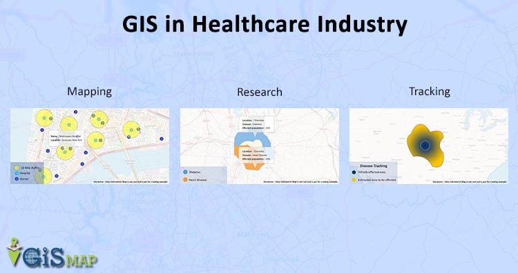
Benefits of GIS in Healthcare Industry :

Healthcare Industries are using the resource integration capabilities of geospatial technologies to create analytical and descriptive solutions for major health issues. Geographical Information System impersonates an important role in improving the quality of care, integrating and analyzing clinical data — alongside environmental data, increasing accessibility of services, finding cheap cost delivery modes, and preserving patient confidentiality while satisfying the needs of the research community for data accessibility.

Here we list out some of the main benefits of using GIS in Healthcare Industry:
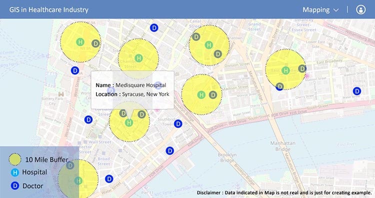
  • Mapping :

    GIS uses maps to analyze and understand the location of doctor or patients or hospitals. GIS mapping of data helps you make informed decisions with a web portal or application. It can provide a web- based portal for every patient or doctor, as you can find your closest doctor or right doctor for your specific need etc. This System includes comprehensive hospital listing locations and the no. of healthcare and social associated employees. These data provide a complete framework for exploring care provider locations.
    Mapping - GIS in Healthcare Industry

  • Tracking :

    Tracking is one of the most powerful aspect provided by GIS in Healthcare Industry. It has ability to use geography and other inputs to identify many new aspects. Let us discuss about two of them.

    1. Tracking of Infectious Diseases : GIS can identify where diseases are most likely to spread next when an Infectious disease is effecting over a wide range of area. Collecting this kind of data can be essential to on-ground working personnel working to save lives because it enables them to prepare in advance for a disease and can severely impact.
    2. Tracking Children Immunizations : GIS tracking can also be used as tracking child immunizations. GIS provides a way to move data from the project level so that it can be used by the entire organization, as it is used to gain a better understanding of Immunizations rates to determine which locations could be rescued during an outbreak.

    Tracking - GIS in Healthcare Industry

  • Helps in Research – GIS in Health Care:

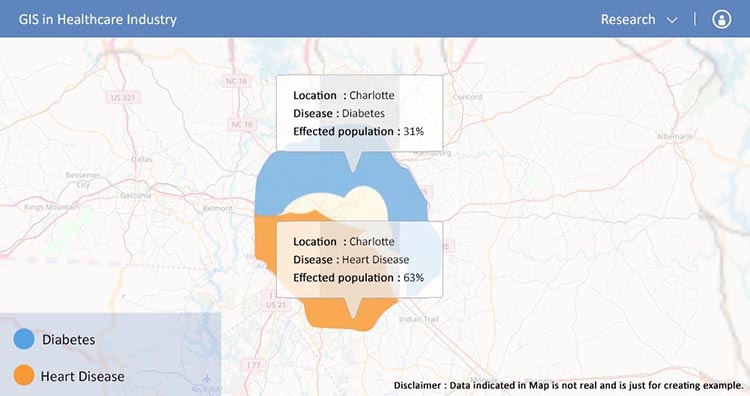
    For broad regional treatment plans the collection of vast amount of accurate personal data is expected to reveal a great deal, but it can also greatly impact personalized healthcare. It has the potential to uncover long-term geographic trends in the health of certain demographics of people living within certain regions of the world.  If the people or individuals have same health condition on same regions, like in a particular area, 70% of the population is suffering from the same common disease. So we can discover about why they all have the same disease? and we could open new realms of healthcare research.
    Research - GIS in Healthcare Industry

  • Discovering Health Trends – With GIS Tool :

    The Geographical Information System provides healthcare industry personnel the ability to recognize health related trends. The GIS offers public healthcare target healing endeavor based upon the result of health related trends. GIS offers a method for health care professionals in which they can address where the diseases are more prevalent or likely to be  widespread in mean time and proactively begins implementation of preventative strategies or begin staffing skilled medical specialists healthcare professionals.

  • Improving Healthcare Services by GIS tool :

    The Geographical Information System helps in identifying the greater needs of specific healthcare services in a large area or country. GIS helps in providing  quick access to medical records, which is crucial to effective treatment. The use of GIS improves national healthcare services as it enables leaders and developers to work more closely with hospitals. And healthcare to take larger steps in addressing national healthcare needs. The geography of health care systems, which  deals with  the planning, management and delivery of suitable health services after determining healthcare needs of target community and service catchment zones. Improving healthcare services is the most important benefit of using GIS in Healthcare Industry.

So, This is how Healthcare System is using GIS for performing their tasks more efficiently. Geographical Information System is a powerful tool that has been successfully implemented to assist address a number of noteworthy health issues ranging from mapping to improved services. Using GIS in Healthcare System is one of the best method to have some control over the management and services. As the healthcare professionals start to adopt and integrate GIS. The number of benefits is likely to rise including the relationship between hospitals and communities. Which is perhaps the most important connection to be made.

Do let us know how this Article is helpful for you, by commenting below in the comment box.