Download Virginia State GIS Maps – Boundary, Counties, Rail, highway

GIS Data and Maps of Virginia State is used by planners and surveyors for visualizing and identifying the patterns that are difficult to examine when data is in table form. Here you can download the GIS data of the state boundary, county division, rail and highway maps in just a few clicks. You can use these data for analysis in MAPOG itself or download them in any suitable GIS format. You can download these data in KML, GeoJSON, CSV or Shapefile formats.

With MAPOG’s versatile toolkit, you can effortlessly upload vector and raster filesadd WMS (Web Map Service) layers, upload Excel or CSV data, incorporate existing files, perform polygon splitting and merging, generate new polygon and polyline data, use the converter for various formats, conduct buffer analysiscreate gridstransform points into polygons, calculate isochrones, and utilize the geocoder for precise location information.

We offer an extensive array of data formats, including KML, SHP, CSV, GeoJSON, Tab, SQL, Tiff, GML, KMZ, GPKZ, SQLITE, Dxf, MIF, TOPOJSON, XLSX, GPX, ODS, MID, and GPS, ensuring compatibility and accessibility for various applications and analyses.

Note:

  • All data available are in GCS datum EPSG:4326 WGS84 CRS (Coordinate Reference System).
  • You need to login for downloading the shapefile

Download Shapefile Data of Virginia State

Virginia officially the Commonwealth of Virginia, is a state in the Mid-Atlantic and South-eastern regions of the United States. Richmond city is the capital city of the state.

Virginia GIS Data - State Boundary
Virginia State Boundary

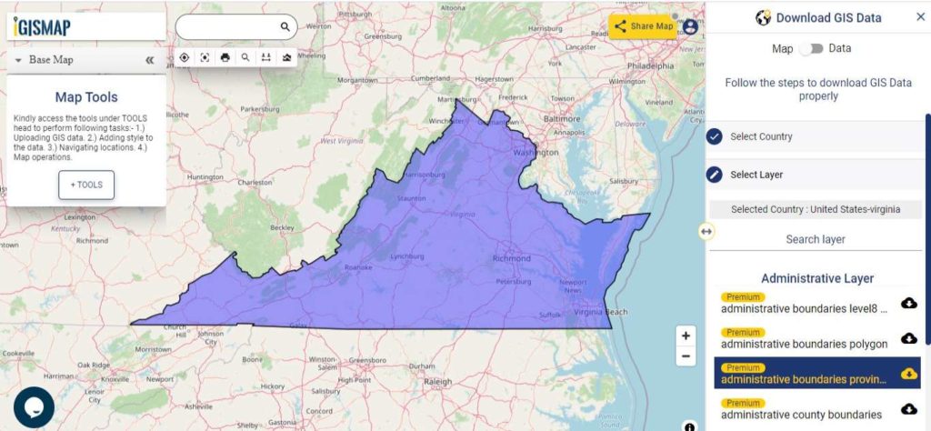
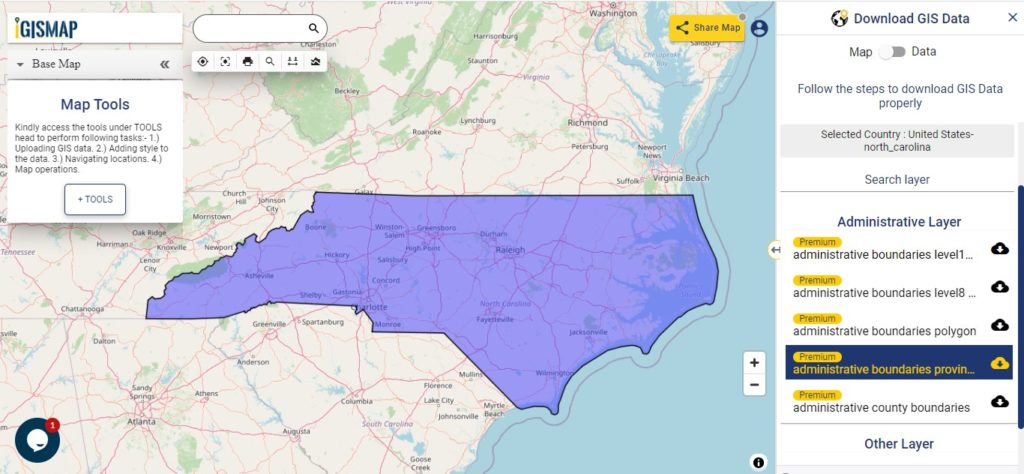
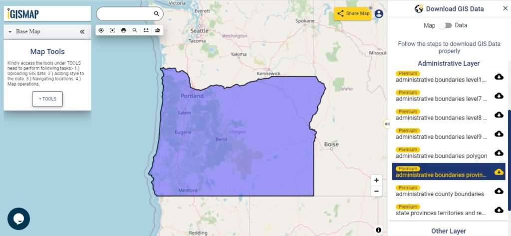
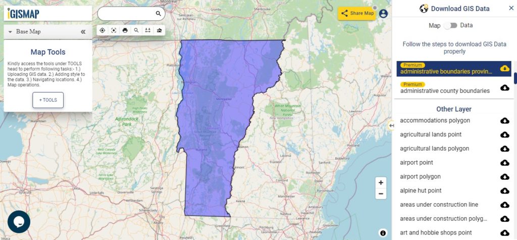
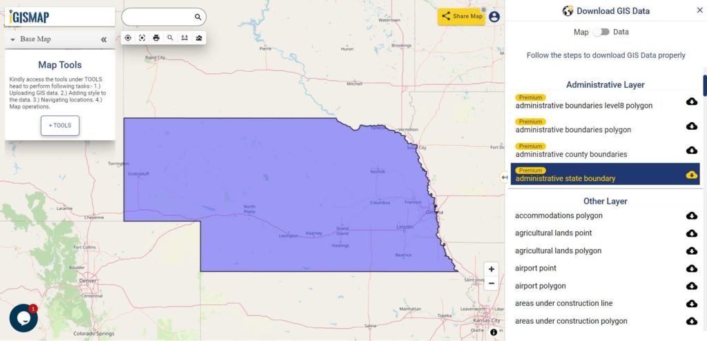
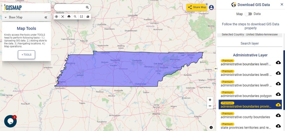
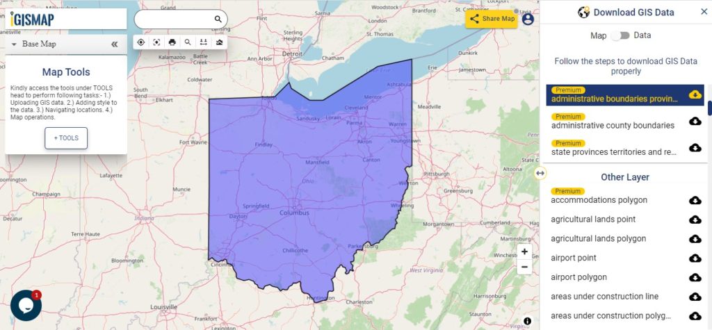
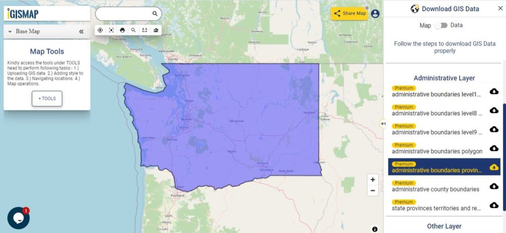
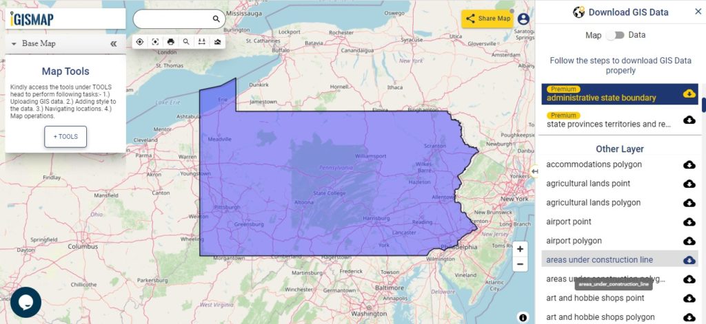
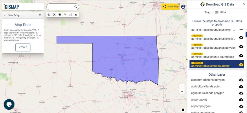
Download Virginia State Outline Boundary Shapefile

In the above screen boundary map of Virginia state. This is the map view for the data table switch button from the map to the data. The layer name is provided on the Right side of the screen. For download click on the button placed beside the map layer name. You can locate your store/ shop on a map.

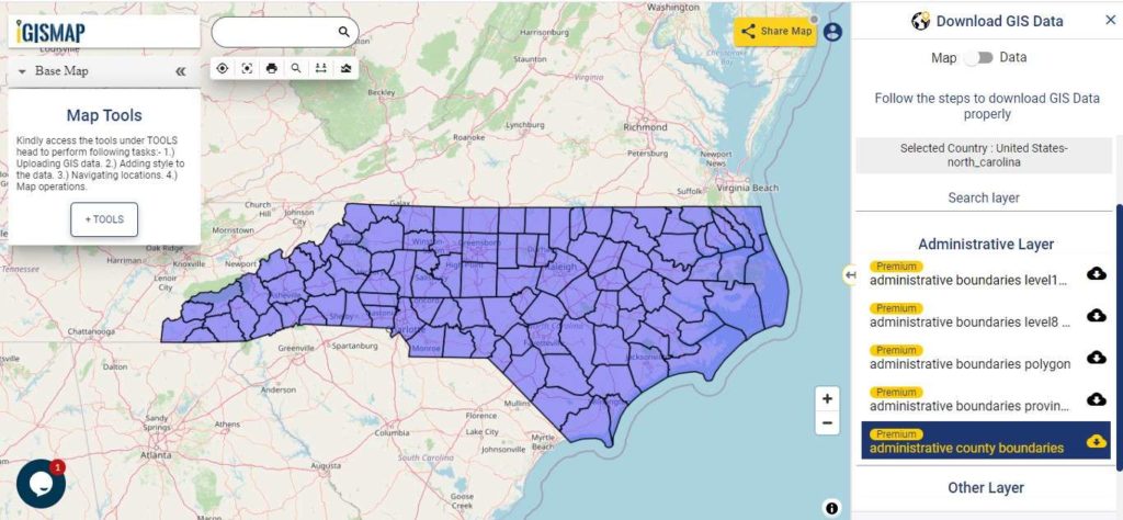
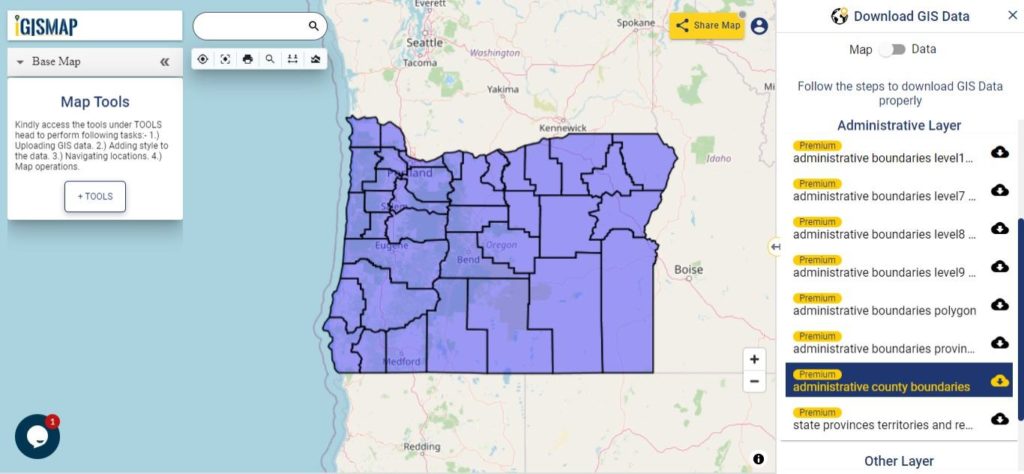
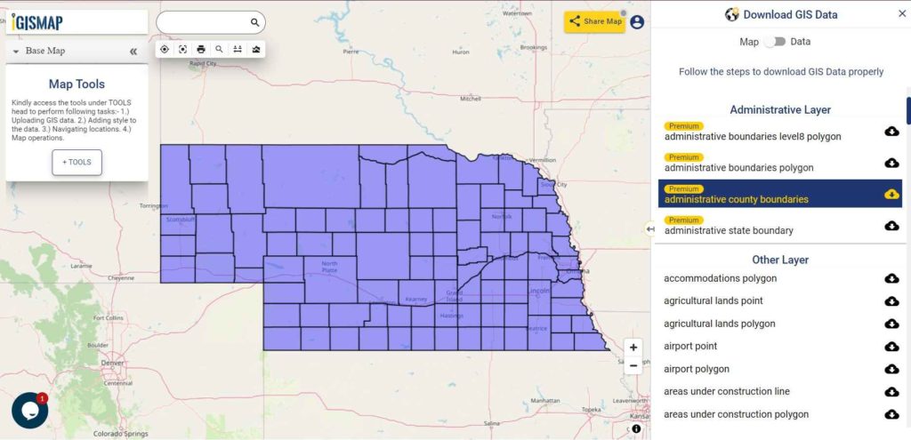
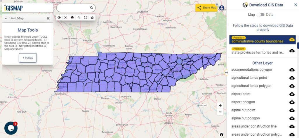
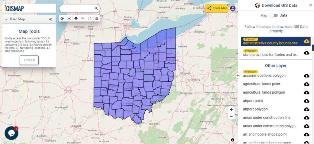
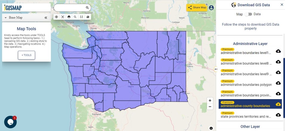
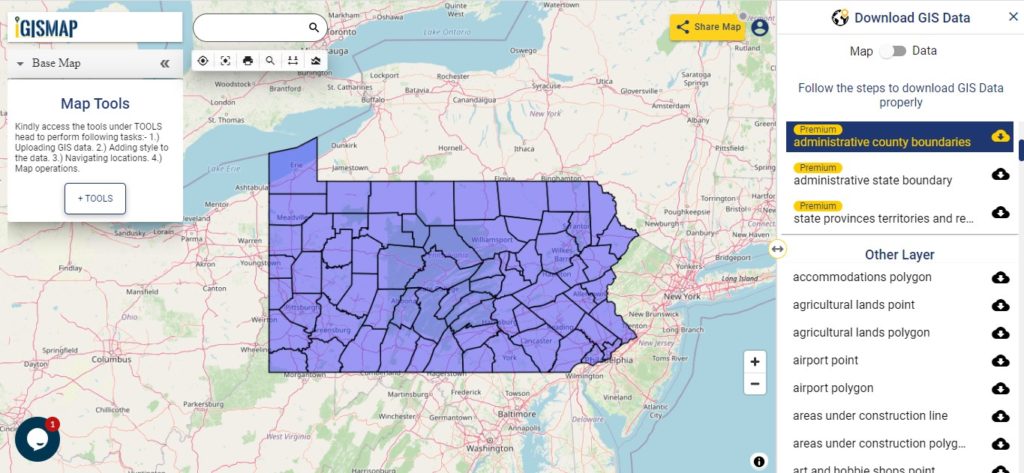
Download Virginia Counties Shapefile Data

There are 95 counties in the U.S. state of Virginia. For a polygon map click on the link given below.

Virginia GIS Data - Counties Boundary
Virginia Counties Boundary

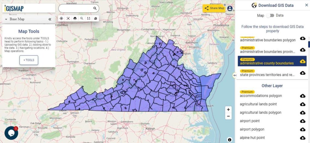
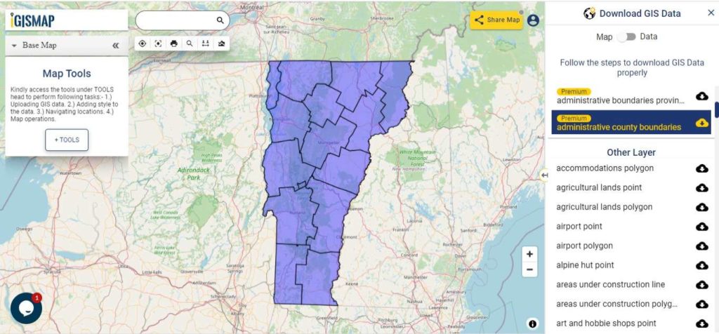
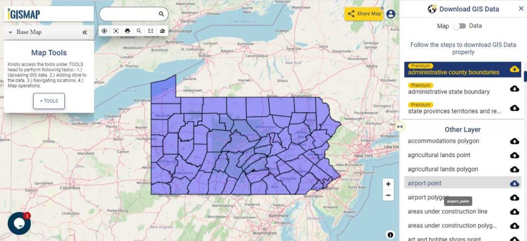
Download Virginia Counties Boundary Shapefile

Polygon map with county division is visible on the above screen. You can easily download and upload in a tool for free and create a map from gis data. Edit, format, add attribute column and share it with your colleagues.

For checking information at a particular location click on the map area and the data table on a particular location will appear.

Above all Layers cover GIS data of following Counties –

Accomack County
Albemarle County
Alleghany County
Amelia County
Amherst County
Appomattox County
Arlington County
Augusta County
Bath County
Bedford County
Bland County
Botetourt County
Brunswick County
Buchanan County
Buckingham County
Campbell County
Caroline County
Carroll County
Charles City County
Charlotte County
Chesterfield County
Clarke County
Craig County
Culpeper County
Cumberland County
Dickenson County
Dinwiddie County
Essex County
Fairfax County
Fauquier County
Floyd County
Fluvanna County
Franklin County
Frederick County
Giles County
Gloucester County
Goochland County
Grayson County
Greene County
Greensville County
Halifax County
Hanover County
Henrico County
Henry County
Highland County
Isle of Wight County
James City County
King and Queen County
King George County
King William County
Lancaster County
Lee County
Loudoun County
Louisa County
Lunenburg County
Madison County
Mathews County
Mecklenburg County
Middlesex County
Montgomery County
Nelson County
New Kent County
Northampton County
Northumberland County
Nottoway County
Orange County
Page County
Patrick County
Pittsylvania County
Powhatan County
Prince Edward County
Prince George County
Prince William County
Pulaski County
Rappahannock County
Richmond County
Roanoke County
Rockbridge County
Rockingham County
Russell County
Scott County
Shenandoah County
Smyth County
Southampton County
Spotsylvania County
Stafford County
Surry County
Sussex County
Tazewell County
Warren County
Washington County
Westmoreland County
Wise County
Wythe County
York County

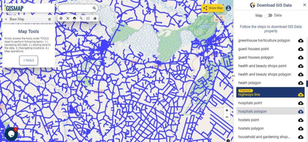
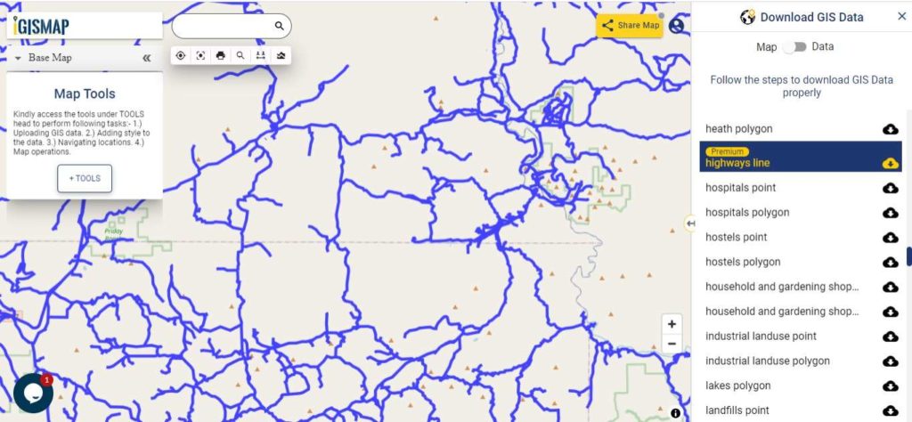
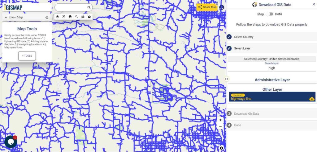
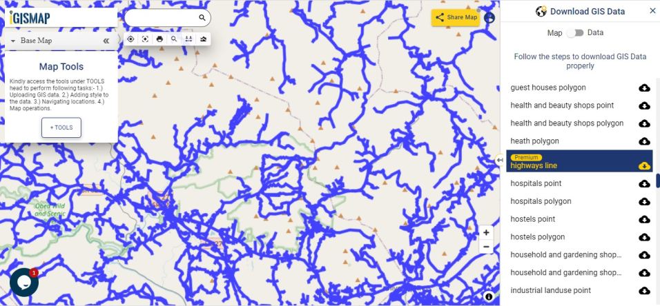
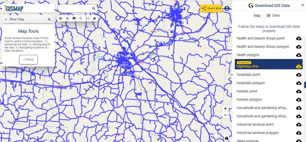
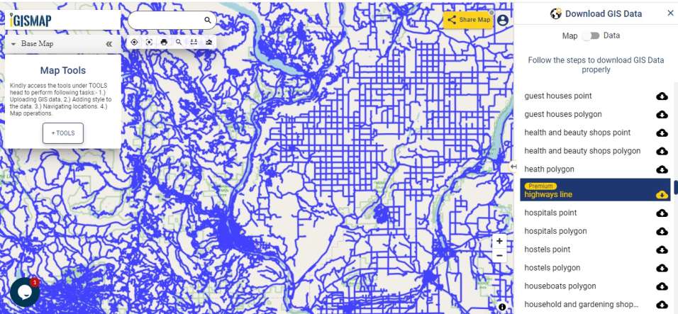
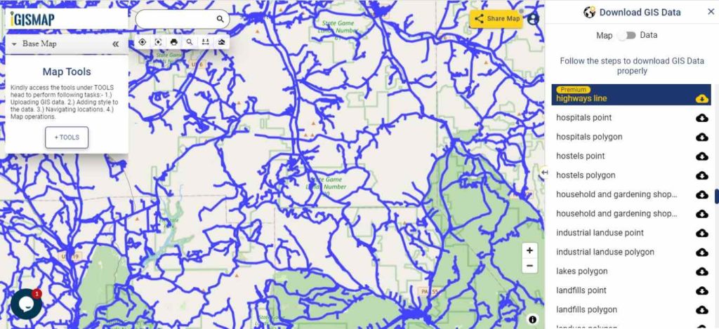
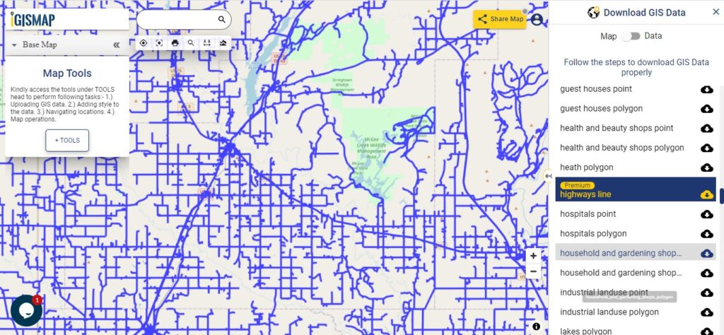
Highway Line GIS Data of Virginia State

Virginia GIS Data - Highway Lines
Virginia Highway Lines

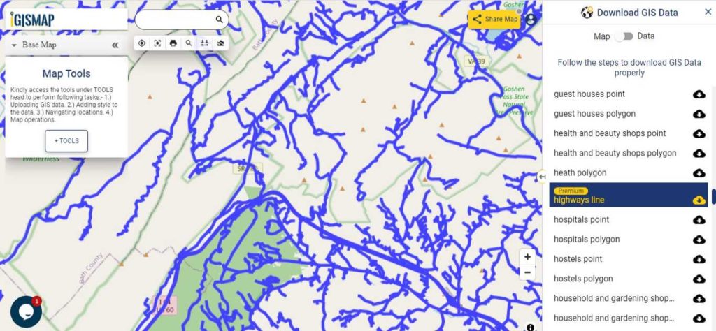
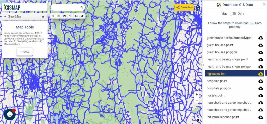
Download Virginia Highway Lines Shapefile

Zoom in view of highway line map is shown shown above. Similarly, you can easily download point based GIS data of airport point, ATM point, parking area, hospital location, etc.

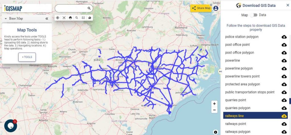
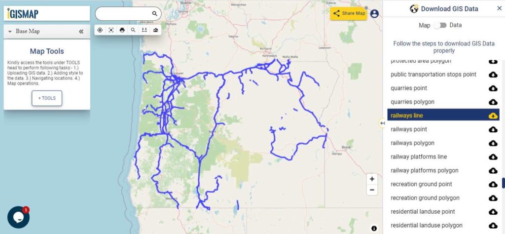
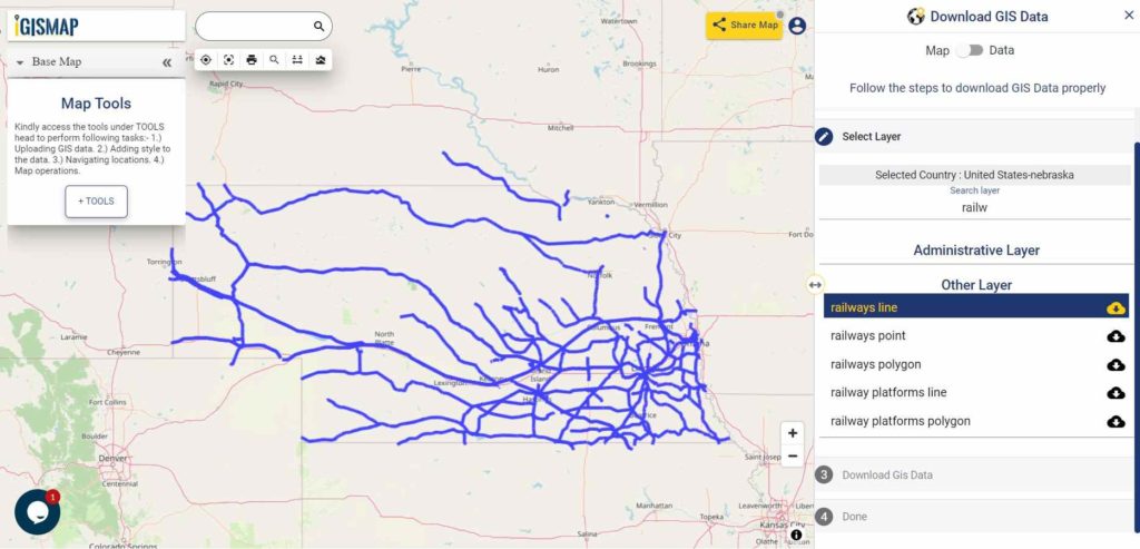
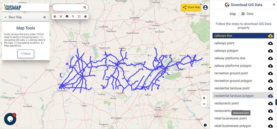
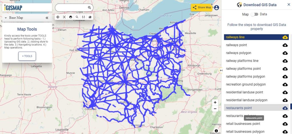
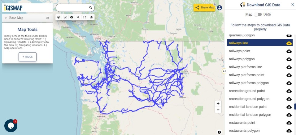
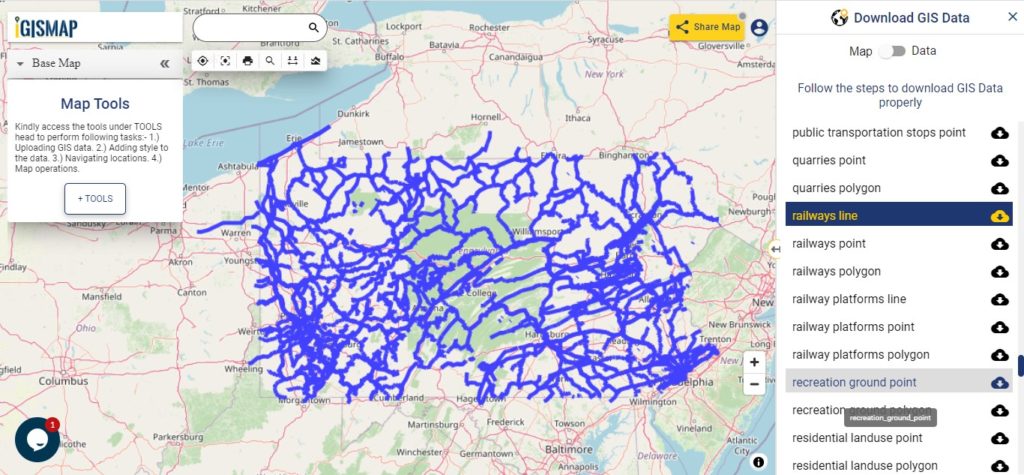
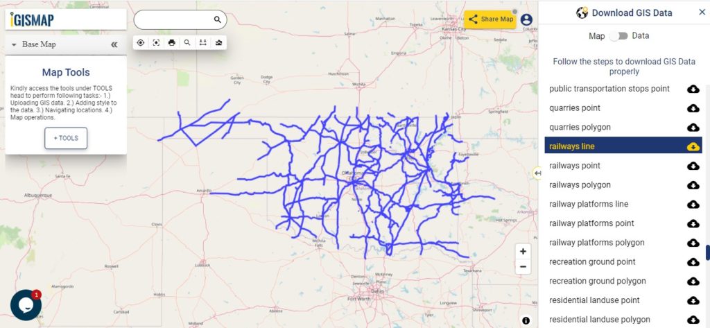
Railways Line GIS Data of Virginia U.S. State

Virginia GIS Data - Railway Lines
Virginia Railway Lines

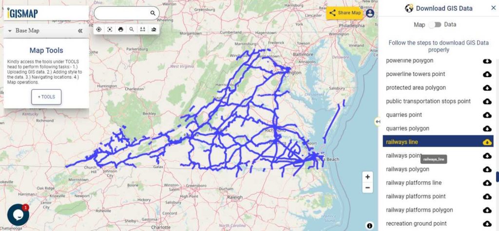
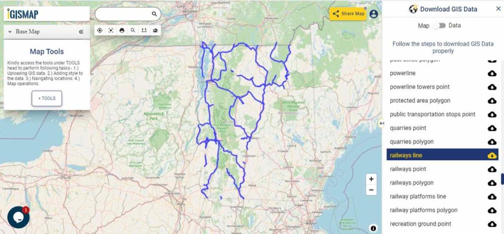
Download Virginia Railway Lines Shapefile

In the above screen railways line map is shown. Likewise, you can download residential land use point, polygon, restaurants, business gis data layers.

In addition to, above enlisted layer if you are looking for any specific data write us on support@mapog.com.

Download GIS Data of other states of USA:

  1. Alabama
  2. Alaska
  3. Arizona
  4. Arkansas
  5. California
  6. Colorado
  7. Connecticut
  8. Florida
  9. Georgia
  10. Hawaii
  11. Idaho
  12. Illinois
  13. Indiana
  14. Iowa
  15. Kansas
  16. Massachusetts
  17. Maryland
  18. Michigan
  19. Minnesota
  20. Mississipi
  21. Missouri
  22. Montana
  23. Nevada
  24. Nebraska
  25. Ohio
  26. Oklahoma
  27. Pennsylvania
  28. Utah
  29. Vermont
  30. Washington
  31. Wisconsin
  32. Wyoming
  33. Tennessee
  34. Texas
  35. Kentucky
  36. Louisiana
  37. Maine
  38. North Carolina
  39. Oregon
  40. Virginia
  41. West Virginia

Disclaimer : If you find any shapefile data of country provided is in correct do contact us or comment below, so that we will correct the same in our system.

Download North Carolina State GIS Maps – Boundary, Counties, Rail, highway

GIS Data and Maps of North Carolina State is used by planners and surveyors for visualizing and identifying the patterns that are difficult to examine when data is in table form. Here you can download the GIS data of the state boundary, county division, rail and highway maps in just a few clicks. You can use these data for analysis in MAPOG itself or download them in any suitable GIS format. You can download these data in KML, GeoJSON, CSV or Shapefile formats.

With MAPOG’s versatile toolkit, you can effortlessly upload vector and raster filesadd WMS (Web Map Service) layers, upload Excel or CSV data, incorporate existing files, perform polygon splitting and merging, generate new polygon and polyline data, use the converter for various formats, conduct buffer analysiscreate gridstransform points into polygons, calculate isochrones, and utilize the geocoder for precise location information.

We offer an extensive array of data formats, including KML, SHP, CSV, GeoJSON, Tab, SQL, Tiff, GML, KMZ, GPKZ, SQLITE, Dxf, MIF, TOPOJSON, XLSX, GPX, ODS, MID, and GPS, ensuring compatibility and accessibility for various applications and analyses.

Note:

  • All data available are in GCS datum EPSG:4326 WGS84 CRS (Coordinate Reference System).
  • You need to login for downloading the shapefile

Download Shapefile Data of North Carolina State

North Carolina is a state in the Southeastern region of the United States. North Carolina is the 28th largest and 9th-most populous of the 50 United States.

North Carolina GIS Data - State Boundary
North Carolina State Boundary

Download North Carolina State Outline Boundary Shapefile

In the above screen boundary map of North Carolina state. This is the map view for the data table switch button from the map to the data. The layer name is provided on the Right side of the screen. For download click on the button placed beside the map layer name. You can locate your store/ shop on a map.

Download North Carolina Counties Shapefile Data

There are 100 counties in the U.S. state of North Carolina. For a polygon map click on the link given below.

North Carolina GIS Data - County Boundaries
North Carolina County Boundaries

Download North Carolina Counties Boundary Shapefile

Polygon map with county division is visible on the above screen. You can easily download and upload in a tool for free and create a map from gis data. Edit, format, add attribute column and share it with your colleagues.

For checking information at a particular location click on the map area and the data table on a particular location will appear.

Above all Layers cover GIS data of following Counties –

Alamance County
Alexander County
Alleghany County
Anson County
Ashe County
Avery County
Beaufort County
Bertie County
Bladen County
Brunswick County
Buncombe County
Burke County
Cabarrus County
Caldwell County
Camden County
Carteret County
Caswell County
Catawba County
Chatham County
Cherokee County
Chowan County
Clay County
Cleveland County
Columbus County
Craven County
Cumberland County
Currituck County
Dare County
Davidson County
Davie County
Duplin County
Durham County
Edgecombe County
Forsyth County
Franklin County
Gaston County
Gates County
Graham County
Granville County
Greene County
Guilford County
Halifax County
Harnett County
Haywood County
Henderson County
Hertford County
Hoke County
Hyde County
Iredell County
Jackson County
Johnston County
Jones County
Lee County
Lenoir County
Lincoln County
Macon County
Madison County
Martin County
McDowell County

Highway Line GIS DATA of North Carolina State

North Carolina GIS Data - Highway Lines
North Carolina Highway Lines

Download North Carolina Highway Lines Shapefile

Zoom in view of highway line map is shown shown above. Similarly, you can easily download point based GIS data of airport point, ATM point, parking area, hospital location, etc.

Railways Line GIS Data of North Carolina U.S. State

North Carolina GIS Data - Railway Lines
North Carolina Railway Lines

Download North Carolina Railway Lines Shapefile

In the above screen railways line map is shown. Likewise, you can download residential land use point, polygon, restaurants, business GIS is data layers.

Download GIS Data of other states of USA:

  1. Alabama
  2. Alaska
  3. Arizona
  4. Arkansas
  5. California
  6. Colorado
  7. Connecticut
  8. Florida
  9. Georgia
  10. Hawaii
  11. Idaho
  12. Illinois
  13. Indiana
  14. Iowa
  15. Kansas
  16. Massachusetts
  17. Maryland
  18. Michigan
  19. Minnesota
  20. Mississipi
  21. Missouri
  22. Montana
  23. Nevada
  24. Nebraska
  25. Ohio
  26. Oklahoma
  27. Pennsylvania
  28. Utah
  29. Vermont
  30. Washington
  31. Wisconsin
  32. Wyoming
  33. Tennessee
  34. Texas
  35. Kentucky
  36. Louisiana
  37. Maine
  38. North Carolina
  39. Oregon
  40. Virginia
  41. West Virginia

Disclaimer : If you find any shapefile data of country provided is in correct do contact us or comment below, so that we will correct the same in our system.

Download Oregon State GIS Maps – Boundary, Counties, Rail, highway

GIS Data and Maps of Oregon State is used by planners and surveyors for visualizing and identifying the patterns that are difficult to examine when data is in table form. Here you can download the GIS data of the state boundary, county division, rail and highway maps in just a few clicks. You can use these data for analysis in MAPOG itself or download them in any suitable GIS format. You can download these data in KML, GeoJSON, CSV or Shapefile formats.

Note:

  • All data available are in GCS datum EPSG:4326 WGS84 CRS (Coordinate Reference System).
  • You need to login for downloading the shapefile.

Download Shapefile Data of Oregon

Oregon is a state in the Pacific Northwest region of the United States. Salem is the capital city of the state. In addition, if you are looking for any other GIS formats then use GIS File Converter.

Oregon GIS Data - State Boundary
Oregon State Boundary

Download Oregon State Outline Boundary Shapefile

In the above screen boundary map of Oregon state. This is the map view for the data table switch button from the map to the data. The layer name is provided on the right side of the screen. For download click on the button placed beside the map layer name. You can locate your store/ shop on a map.

Download Oregon Counties Shapefile Data

There are 36 counties in the U.S. state of Oregon.

Oregon GIS Data - Counties Boundary
Oregon Counties Boundary

Download Oregon Counties Boundary Shapefile

Polygon map with county division is visible on the above screen. You can easily download and upload in a tool for free and create a map from gis data. Edit, format, add attribute column and share it with your colleagues.

For checking information at a particular location click on the map area and the data table on a particular location will appear.

Above all Layers cover GIS data of following Counties –

Baker County
Benton County
Clackamas County
Clatsop County
Columbia County
Coos County
Crook County
Curry County
Deschutes County
Douglas County
Gilliam County
Grant County
Harney County
Hood River County
Jackson County
Jefferson County
Josephine County
Klamath County
Lake County
Lane County
Lincoln County
Linn County
Malheur County
Marion County
Morrow County
Multnomah County
Polk County
Sherman County
Tillamook County
Umatilla County
Union County
Wallowa County
Wasco County
Washington County
Wheeler County
Yamhill County

Highway Line GIS Data of Oregon State

Oregon GIS Data - Highway Lines
Oregon Highway Lines

Download Vermont Highway Lines Shapefile

Zoom in view of highway line map is shown shown above. Similarly, you can easily download point based GIS data of airport point, ATM point, parking area, hospital location, etc.

Railways Line GIS Data of Oregon U.S. State

Oregon GIS Data - Railway Lines
Oregon Railway Lines

Download Oregon Railway Lines Shapefile

In the above screen railways line map is shown. Likewise, you can download residential land use point, polygon, restaurants, business GIS data layers.

Download GIS Data of other states of USA:

  1. Alabama
  2. Alaska
  3. Arizona
  4. Arkansas
  5. California
  6. Colorado
  7. Connecticut
  8. Florida
  9. Georgia
  10. Hawaii
  11. Idaho
  12. Illinois
  13. Indiana
  14. Iowa
  15. Kansas
  16. Massachusetts
  17. Maryland
  18. Michigan
  19. Minnesota
  20. Mississipi
  21. Missouri
  22. Montana
  23. Nevada
  24. Nebraska
  25. Ohio
  26. Oklahoma
  27. Pennsylvania
  28. Utah
  29. Vermont
  30. Washington
  31. Wisconsin
  32. Wyoming
  33. Tennessee
  34. Texas
  35. Kentucky
  36. Louisiana
  37. Maine
  38. North Carolina
  39. Oregon
  40. Virginia
  41. West Virginia

Disclaimer : If you find any shapefile data of country provided is in correct do contact us or comment below, so that we will correct the same in our system.

Download Vermont State GIS Maps – Boundary, Counties, Rail, highway

GIS Data and Maps of Vermont State is used by planners and surveyors for visualizing and identifying the patterns that are difficult to examine when data is in table form. Here you can download the GIS data of the state boundary, county division, rail and highway maps in just a few clicks. You can use these data for analysis in MAPOG itself or download them in any suitable GIS format. You can download these data in KML, GeoJSON, CSV or Shapefile formats.

Note:

  • All data available are in GCS datum EPSG:4326 WGS84 CRS (Coordinate Reference System).
  • You need to login for downloading the shapefile.

Download Free Shapefile Data of Vermont

Vermont is a state in the New England region of the United States. Montpelier city is the capital city of the state. In addition, if you are looking for any other GIS formats then use GIS File Converter.

Vermont GIS Data - State Boundary
Vermont State Boundary

Download Vermont State Outline Boundary Shapefile

In the above screen boundary map of Vermont state. This is the map view for the data table switch button from the map to the data. The layer name is provided on the right side of the screen. For download click on the button placed beside the map layer name. You can locate your store/ shop on a map.

Download Vermont Counties Shapefile Data

There are 14 counties in the U.S. state of Oregon. For a polygon map click on the link given below.

Vermont GIS Data - County Boundaries
Vermont County Boundaries

Download Vermont Counties Boundary Shapefile

Polygon map with county division is visible on the above screen. You can easily download and upload in a tool for free and create a map from GIS data. Edit, format, add attribute column and share it with your colleagues.

For checking information at a particular location click on the map area and the data table on a particular location will appear.

Above all Layers cover GIS data of following Counties –

Addison County
Bennington County
Caledonia County
Chittenden County
Essex County
Franklin County
Grand Isle County
Lamoille County
Orange County
Orleans County
Rutland County
Washington County
Windham County
Windsor County

Highway Line GIS data of Vermont State

Vermont GIS Data - Highway Lines
Vermont Highway Lines

Download Vermont Highway Lines Shapefile

Zoom in view of highway line map is shown shown above. Similarly, you can easily download point based GIS data of airport point, ATM point, parking area, hospital location, etc.

Railways Line Gis Data of Vermont U.S. State

Vermont GIS Data - Railway Lines
Vermont Railway Lines

Download Vermont Railway Lines Shapefile

In the above screen railways line map is shown. Likewise, you can download residential land use point, polygon, restaurants, business GIS data layers.

Download GIS Data of other states of USA:

  1. Alabama
  2. Alaska
  3. Arizona
  4. Arkansas
  5. California
  6. Colorado
  7. Connecticut
  8. Florida
  9. Georgia
  10. Hawaii
  11. Idaho
  12. Illinois
  13. Indiana
  14. Iowa
  15. Kansas
  16. Massachusetts
  17. Maryland
  18. Michigan
  19. Minnesota
  20. Mississipi
  21. Missouri
  22. Montana
  23. Nevada
  24. Nebraska
  25. Ohio
  26. Oklahoma
  27. Pennsylvania
  28. Utah
  29. Vermont
  30. Washington
  31. Wisconsin
  32. Wyoming
  33. Tennessee
  34. Texas
  35. Kentucky
  36. Louisiana
  37. Maine
  38. North Carolina
  39. Oregon
  40. Virginia
  41. West Virginia

Disclaimer : If you find any shapefile data of country provided is in correct do contact us or comment below, so that we will correct the same in our system.

Download Nebraska State GIS Maps – Boundary, Counties, Railway, Highway

GIS Data and Maps of Nebraska State is used by planners and surveyors for visualizing and identifying the patterns that are difficult to examine when data is in table form. Here you can download the GIS data of the state boundary, county division, rail and highway maps in just a few clicks. You can use these data for analysis in IGISMAP itself or download them in any suitable GIS format. You can download these data in KML, GeoJSON, CSV or Shapefile formats.

Note:

  • All data available are in GCS datum EPSG:4326 WGS84 CRS (Coordinate Reference System).
  • You need to login for downloading the shapefile.

Download Shapefile Data of Nebraska

Nebraska is a state in the Midwestern region of the United States. It is bordered by South Dakota to the north; Iowa to the east and Missouri to the southeast, both across the Missouri River; Kansas to the south; Colorado to the southwest; and Wyoming to the west. It is the only triply landlocked U.S. state. In addition, if you are looking for any other GIS formats then use GIS File Converter.

Nebraska GIS Data - State Boundary
Nebraska State Boundary

Download Nebraska State Outline Boundary Shapefile

In the above screen state boundary map of Nebraska state. This is the map view for the data table switch button from the map to the data. The layer name is provided on the right side of the screen. For download click on the button placed beside the map layer name. You can locate your store/ shop on a map.

Download Nebraska Counties Shapefile Data

There are 93 counties in the U.S. state of Nebraska. For a polygon map click on the link given below.

Nebraska GIS Data - County Boundaries
Nebraska County Boundaries

Download Nebraska County Boundaries Shapefile

Polygon map with county division is visible on the above screen. You can easily download and upload in a tool for free and create a map from GIS data, edit the format, add attribute column and share it with your colleagues.

Above layer cover the boundary feature of the following counties

Omaha
Lincoln
Bellevue
Grand Island
Kearney
Fremont
Hastings
North Platte
Norfolk
Columbus
Papillion
La Vista
Scottsbluff
South Sioux City
Beatrice
Lexington
Alliance
Gering
Blair
York
McCook
Nebraska City
Ralston
Crete
Seward
Sidney
Plattsmouth
Schuyler
Chadron
Gretna
Wayne
Holdrege
Ogallala
Wahoo
Aurora
Falls City
Cozad
Fairbury
O’Neill
Waverly
Gothenburg
Broken Bow
Auburn
West Point
Minden
Central City
David City
Valentine
Ashland
Kimball
Madison
St. Paul
Milford
Geneva
Imperial
Ord
Valley

Highway Line GIS Data of Nebraska State

Nebraska GIS Data - Highway Lines
Nebraska Highway Lines

Download Nebraska Highway Lines Shapefile

In the above map, zoom in view of highway line map is shown. Similarly, you can easily download point based GIS data of airport locations, ATM locations, parking locations, hospital location, etc.

Railways Line GIS Data of Nebraska State

Nebraska GIS Data - Railway Lines
Nebraska Railway Lines

Download Nebraska Railway Lines Shapefile

In the above screen railways line map is shown. Likewise, you can download residential land use point, polygon, restaurants, business GIS data layers.

For more specific GIS data write us on support@mapog.com.

Download GIS Data of other states of USA:

  1. Alabama
  2. Alaska
  3. Arizona
  4. Arkansas
  5. California
  6. Colorado
  7. Connecticut
  8. Florida
  9. Georgia
  10. Hawaii
  11. Idaho
  12. Illinois
  13. Indiana
  14. Iowa
  15. Kansas
  16. Massachusetts
  17. Maryland
  18. Michigan
  19. Minnesota
  20. Mississipi
  21. Missouri
  22. Montana
  23. Nevada
  24. Nebraska
  25. Ohio
  26. Oklahoma
  27. Pennsylvania
  28. Utah
  29. Vermont
  30. Washington
  31. Wisconsin
  32. Wyoming
  33. Tennessee
  34. Texas
  35. Kentucky
  36. Louisiana
  37. Maine
  38. North Carolina
  39. Oregon
  40. Virginia
  41. West Virginia

Disclaimer : If you find any shapefile data of country provided is in correct do contact us or comment below, so that we will correct the same in our system.

Download Tennessee State GIS Maps – Boundary, Counties, Rail, highway

GIS Data and Maps of Tennessee State is used by planners and surveyors for visualizing and identifying the patterns that are difficult to examine when data is in table form. Here you can download the GIS data of the state boundary, county division, rail and highway maps in just a few clicks. You can use these data for analysis in MAPOG itself or download them in any suitable GIS format. You can download these data in KML, GeoJSON, CSV or Shapefile formats.

Note:

  • All data available are in GCS datum EPSG:4326 WGS84 CRS (Coordinate Reference System).
  • You need to login for downloading the shapefile.

Download Shapefile Data of Tennessee

Officially the State of Tennessee, is a state in the Southeastern region of the United States. Tennessee is the 36th largest by area and the 16th most populous of the 50 states. It is bordered by Kentucky to the north, Virginia to the northeast, North Carolina to the east, Georgia, Alabama, and Mississippi to the south, Arkansas to the southwest, and Missouri to the northwest. Tennessee is geographically, culturally, and legally divided into three Grand Divisions of East, Middle, and West Tennessee. Nashville is the state’s capital and largest city, and anchors its largest metropolitan area. Other major cities include Memphis, Knoxville, Chattanooga, and Clarksville. In addition, if you are looking for any other GIS formats then use GIS File Converter.

Tennessee GIS Data - State Boundary
Tennessee State Boundary

Download Tennessee State Outline Boundary Shapefile

Download Tennessee Counties Shapefile Data

There are 95 counties in the U.S. state of Tennessee.

Tennessee GIS Data - County Boundaries
Tennessee County Boundaries

Download Tennessee County Boundaries Shapefile

Polygon map with county division is visible on the above screen. You can easily download and upload in a tool for free and create a map from GIS data, edit the format, add attribute column and share it with your colleagues.

Above layer cover the boundary feature of the following counties

Anderson County
Bedford County
Benton County
Bledsoe County
Blount County
Bradley County
Campbell County
Cannon County
Carroll County
Carter County
Cheatham County
Chester County
Claiborne County
Clay County
Cocke County
Coffee County
Crockett County
Cumberland County
Davidson County
Decatur County
DeKalb County
Dickson County
Dyer County
Fayette County
Fentress County
Franklin County
Gibson County
Giles County
Grainger County
Greene County
Grundy County
Hamblen County
Hamilton County
Hancock County
Hardeman County
Hardin County
Hawkins County
Haywood County
Henderson County
Henry County
Hickman County
Houston County
Humphreys County
Jackson County
Jefferson County
Johnson County
Knox County
Lake County
Lauderdale County
Lawrence County
Lewis County
Lincoln County
Loudon County
Macon County
Madison County
Marion County
Marshall County
Maury County
McMinn County
McNairy County
Meigs County
Monroe County
Montgomery County
Moore County
Morgan County
Obion County
Overton County
Perry County
Pickett County
Polk County
Putnam County
Rhea County
Roane County
Robertson County
Rutherford County
Scott County
Sequatchie County
Sevier County
Shelby County
Smith County
Stewart County
Sullivan County
Sumner County
Tipton County
Trousdale County
Unicoi County
Union County
Van Buren County
Warren County
Washington County
Wayne County
Weakley County
White County
Williamson County
Wilson County

Highway Line GIS Data of Tennessee State

Tennessee GIS Data - Highway Lines
Tennessee Highway Lines

Download Tennessee Highway Lines Shapefile

In the above map, zoom in view of highway line map is shown. Similarly, you can easily download point based GIS data of airport locations, ATM locations, parking locations, hospital location, etc.

Railways Line GIS Data of Tennessee State

Tennessee GIS Data - Railway Lines
Tennessee Railway Lines

Download Tennessee Railway Lines Shapefile

In the above screen railways line map is shown. Likewise, you can download residential land use point, polygon, restaurants, business GIS data layers.

Download GIS Data of other states of USA:

  1. Alabama
  2. Alaska
  3. Arizona
  4. Arkansas
  5. California
  6. Colorado
  7. Connecticut
  8. Florida
  9. Georgia
  10. Hawaii
  11. Idaho
  12. Illinois
  13. Indiana
  14. Iowa
  15. Kansas
  16. Massachusetts
  17. Maryland
  18. Michigan
  19. Minnesota
  20. Mississipi
  21. Missouri
  22. Montana
  23. Nevada
  24. Nebraska
  25. Ohio
  26. Oklahoma
  27. Pennsylvania
  28. Utah
  29. Vermont
  30. Washington
  31. Wisconsin
  32. Wyoming
  33. Tennessee
  34. Texas
  35. Kentucky
  36. Louisiana
  37. Maine
  38. North Carolina
  39. Oregon
  40. Virginia
  41. West Virginia

Disclaimer : If you find any shapefile data of country provided is in correct do contact us or comment below, so that we will correct the same in our system.

Download Ohio State GIS Maps – Boundary, Counties, Rail, highway

GIS Data and Maps of Ohio State is used by planners and surveyors for visualizing and identifying the patterns that are difficult to examine when data is in table form. Here you can download the GIS data of the state boundary, county division, rail and highway maps in just a few clicks. You can use these data for analysis in MAPOG itself or download them in any suitable GIS format. You can download these data in KML, GeoJSON, CSV or Shapefile formats.

Note:

  • All data available are in GCS datum EPSG:4326 WGS84 CRS (Coordinate Reference System).
  • You need to login for downloading the shapefile.

Download Shapefile Data of Ohio

Ohio is a is a state in the Midwestern region of the United States. Of the fifty U.S. states, it is the 34th-largest by area, and with a population of nearly 11.8 million, is the seventh-most populous and tenth-most densely populated. The state’s capital and largest city is Columbus, with the Columbus metro area, Greater Cincinnati, and Greater Cleveland being the largest metropolitan areas. Ohio is bordered by Lake Erie to the north, Pennsylvania to the east, West Virginia to the southeast, Kentucky to the southwest, Indiana to the west, and Michigan to the northwest.

Ohio GIS Data - State Boundary
Ohio State Boundary

Download Ohio State Outline Boundary Shapefile

Download Ohio Counties Shapefile Data

There are 88 counties in the U.S. state of Ohio. For a polygon map click on the link given below.

Ohio GIS Data - County Boundaries
Ohio County Boundaries

Download Ohio County Boundaries Shapefile

Polygon map with county division is visible on the above screen. You can easily download and upload in a tool for free and create a map from GIS data, edit the format, add attribute column and share it with your colleagues.

Above layer cover the boundary feature of the following counties

Adams County
Allen County
Ashland County
Ashtabula County
Athens County
Auglaize County
Belmont County
Brown County
Butler County
Carroll County
Champaign County
Clark County
Clermont County
Clinton County
Columbiana County
Coshocton County
Crawford County
Cuyahoga County
Darke County
Defiance County
Delaware County
Erie County
Fairfield County
Fayette County
Franklin County
Fulton County
Gallia County
Geauga County
Greene County
Guernsey County
Hamilton County
Hancock County
Hardin County
Harrison County
Henry County
Highland County
Hocking County
Holmes County
Huron County
Jackson County
Jefferson County
Knox County
Lake County
Lawrence County
Licking County
Logan County
Lorain County
Lucas County
Madison County
Mahoning County
Marion County
Medina County
Meigs County
Mercer County
Miami County
Monroe County
Montgomery County
Morgan County
Morrow County
Muskingum County
Noble County
Ottawa County
Paulding County
Perry County
Pickaway County
Pike County
Portage County
Preble County
Putnam County
Richland County
Ross County
Sandusky County
Scioto County
Seneca County
Shelby County
Stark County
Summit County
Trumbull County
Tuscarawas County
Union County
Van Wert County
Vinton County
Warren County
Washington County
Wayne County
Williams County
Wood County

Highway Line GIS Data of Ohio State

Ohio GIS Data - Highway Lines
Ohio Highway Lines

Download Ohio Highway Lines Shapefile

In the above map, zoom in view of highway line map is shown. Similarly, you can easily download point based GIS data of airport locations, ATM locations, parking locations, hospital location, etc..

Railways Line GIS Data of Ohio State

Ohio GIS Data - Railway Lines
Ohio Railway Lines

Download Ohio Railway Lines Shapefile

On the above screen, a railway line map is shown. Likewise, you can download residential land use points, polygon, restaurants, business GIS data layers.

Furthermore, for more specific data or issues in downloading above all links then write us at support@mapog.com. Similarly, if you want to upload any GIS data and perform various operations.

Download GIS Data of other states of USA:

  1. Alabama
  2. Alaska
  3. Arizona
  4. Arkansas
  5. California
  6. Colorado
  7. Connecticut
  8. Florida
  9. Georgia
  10. Hawaii
  11. Idaho
  12. Illinois
  13. Indiana
  14. Iowa
  15. Kansas
  16. Massachusetts
  17. Maryland
  18. Michigan
  19. Minnesota
  20. Mississipi
  21. Missouri
  22. Montana
  23. Nevada
  24. Nebraska
  25. Ohio
  26. Oklahoma
  27. Pennsylvania
  28. Utah
  29. Vermont
  30. Washington
  31. Wisconsin
  32. Wyoming
  33. Tennessee
  34. Texas
  35. Kentucky
  36. Louisiana
  37. Maine
  38. North Carolina
  39. Oregon
  40. Virginia
  41. West Virginia

Disclaimer : If you find any shapefile data of country provided is in correct do contact us or comment below, so that we will correct the same in our system.

Download Washington State GIS Maps – Boundary, Counties, Rail, highway

GIS Data and Maps of Washington State is used by planners and surveyors for visualizing and identifying the patterns that are difficult to examine when data is in table form. Here you can download the GIS data of the state boundary, county division, rail and highway maps in just a few clicks. You can use these data for analysis in MAPOG itself or download them in any suitable GIS format. You can download these data in KML, GeoJSON, CSV or Shapefile formats

Note:

  • All data available are in GCS datum EPSG:4326 WGS84 CRS (Coordinate Reference System).
  • You need to login for downloading the shapefile

Download Shapefile Data Washington State

State of Washington, is a state in the Pacific Northwest region of the United States. Seatle is the capital city of the state. In addition, if you are looking for any other GIS formats then use GIS File Converter.

Weashington GIS Data - State Boundary
Weashington State Boundary

Download Wshington State Boundary Shapefile

In the above screen boundary map of Washington state. This is the map view for the data table switch button from the map to the data. The layer name is provided on the right side of the screen. For download click on the button placed beside the map layer name. You can locate your store/ shop on a map.

Download Washington Counties Shapefile Data

There are 39 counties in the U.S. state of Washington.

Washington GIS Data - County Boundary
Washington County Boundary

Download Wshington County Boundary Shapefile

Polygon map with county division is visible on the above screen. You can easily download and upload in a tool for free and create a map from GIS data. Edit, format, add attribute column and share it with your colleagues.

Above all Layers cover GIS data of following Counties –

  1. Asotin County
  2. Benton County
  3. Chelan County
  4. Clallam County
  5. Clark County
  6. Columbia County
  7. Cowlitz County
  8. Douglas County
  9. Ferry County
  10. Franklin County
  11. Garfield County (Palouse Economic Development Council)
  12. Grant County
  13. Grays Harbor County
  14. Island County
  15. Jefferson County
  16. King County
  17. Kitsap County
  18. Kittitas County
  19. Klickitat County
  20. Lewis County
  21. Lincoln County
  22. Mason County
  23. Okanogan County
  24. Pacific County
  25. Pend Oreille County
  26. Pierce County
  27. San Juan County
  28. Skagit County
  29. Skamania County
  30. Snohomish County
  31. Spokane County
  32. Stevens County
  33. Thurston County
  34. Wahkiakum County
  35. Walla Walla County
  36. Whatcom County
  37. Whitman County
  38. Yakima County

Highway Line GIS Data of U.S. Washington State

Washington GIS Data - Highway Line
Washington Highway Line

Download Wshington Highway Line Shapefile

Zoom in view of highway line map is shown shown above. Similarly, you can easily download point based GIS data of airport point, ATM point, parking area, hospital location, etc.

Railways Line Gis Data of Washington U.S. State

Washington GIS Data - Railway Lines
Washington Railway Lines

Download Wshington Railway Line Shapefile

In the above screen railways line map is shown. Likewise, you can download residential land use point, polygon, restaurants, business GIS data layers.

Download GIS Data of other states of USA:

  1. Alabama
  2. Alaska
  3. Arizona
  4. Arkansas
  5. California
  6. Colorado
  7. Connecticut
  8. Florida
  9. Georgia
  10. Hawaii
  11. Idaho
  12. Illinois
  13. Indiana
  14. Iowa
  15. Kansas
  16. Massachusetts
  17. Maryland
  18. Michigan
  19. Minnesota
  20. Mississipi
  21. Missouri
  22. Montana
  23. Nevada
  24. Nebraska
  25. Ohio
  26. Oklahoma
  27. Pennsylvania
  28. Utah
  29. Vermont
  30. Washington
  31. Wisconsin
  32. Wyoming
  33. Tennessee
  34. Texas
  35. Kentucky
  36. Louisiana
  37. Maine
  38. North Carolina
  39. Oregon
  40. Virginia
  41. West Virginia

Disclaimer : If you find any shapefile data of country provided is in correct do contact us or comment below, so that we will correct the same in our system.

Download Pennsylvania State GIS Maps – Boundary, Counties, Rail, highway

GIS Data and Maps of Pennsylvania State is used by planners and surveyors for visualizing and identifying the patterns that are difficult to examine when data is in table form. Here you can download the GIS data of the state boundary, county division, rail and highway maps in just a few clicks. You can use these data for analysis in MAPOG itself or download them in any suitable GIS format. You can download these data in KML, GeoJSON, CSV or Shapefile formats.

Note:

  • All data available are in GCS datum EPSG:4326 WGS84 CRS (Coordinate Reference System).
  • You need to login for downloading the shapefile.

Download Shapefile Data of Pennsylvania

Pennsylvania, officially the Commonwealth of Pennsylvania, is a U.S. state spanning the Mid-Atlantic, Northeastern, and Appalachian regions of the United States. It borders Delaware to the southeast, Maryland to the south, West Virginia to the southwest, Ohio to the west, Lake Erie and the Canadian province of Ontario to the northwest, New York to the north, and New Jersey to the east. In addition, if you are looking for any other GIS formats then use GIS File Converter.

Pennsylvania GIS Data - State Boundary
Pennsylvania State Boundary

Download Pennsylvania State Outline Boundary Shapefile

Download Pennsylvania Counties Shapefile Data

There are 67 counties in the U.S. state of Pennsylvania. For a polygon map click on the link given below.

Pennsylvania GIS Data - County Boundaries
Pennsylvania County Boundaries

Download Pennsylvania County Boundaries Shapefile

Polygon map with county division is visible on the above screen. You can easily download and upload in a tool for free and create a map from GIS data, edit the format, add attribute column and share it with your colleagues.

Above layer cover the boundary feature of the following counties

Adams County
Allegheny County
Armstrong County
Beaver County
Bedford County
Berks County
Blair County
Bradford County
Bucks County
Butler County
Cambria County
Cameron County
Carbon County
Centre County
Chester County
Clarion County
Clearfield County
Clinton County
Columbia County
Crawford County
Cumberland County
Dauphin County
Delaware County
Elk County
Erie County
Fayette County
Forest County
Franklin County
Fulton County
Greene County
Huntingdon County
Indiana County
Jefferson County
Juniata County
Lackawanna County
Lancaster County
Lawrence County
Lebanon County
Lehigh County
Luzerne County
Lycoming County
McKean County
Mercer County
Mifflin County
Monroe County
Montgomery County
Montour County
Northampton County
Northumberland County
Perry County
Philadelphia County
Pike County
Potter County
Schuylkill County
Snyder County
Somerset County
Sullivan County
Susquehanna County
Tioga County
Union County
Venango County
Warren County
Washington County
Wayne County
Westmoreland County
Wyoming County
York County

Highway Line GIS Data of Pennsylvania State

Pennsylvania GIS Data - Highway Lines
Pennsylvania Highway Lines

Download Pennsylvania Highway Lines Shapefile

In the above map, zoom in view of highway line map is shown. Similarly, you can easily download point based GIS data of airport locations, ATM locations, parking locations, hospital location, etc.

Railways Line GIS Data of Pennsylvania State

Pennsylvania GIS Data - Railway Lines
Pennsylvania Railway Lines

Download Pennsylvania Railway Lines Shapefile

In the above screen railways line map is shown. Likewise, you can download residential land use point, polygon, restaurants, business GIS data layers.

Download GIS Data of other states of USA:

  1. Alabama
  2. Alaska
  3. Arizona
  4. Arkansas
  5. California
  6. Colorado
  7. Connecticut
  8. Florida
  9. Georgia
  10. Hawaii
  11. Idaho
  12. Illinois
  13. Indiana
  14. Iowa
  15. Kansas
  16. Massachusetts
  17. Maryland
  18. Michigan
  19. Minnesota
  20. Mississipi
  21. Missouri
  22. Montana
  23. Nevada
  24. Nebraska
  25. Ohio
  26. Oklahoma
  27. Pennsylvania
  28. Utah
  29. Vermont
  30. Washington
  31. Wisconsin
  32. Wyoming
  33. Tennessee
  34. Texas
  35. Kentucky
  36. Louisiana
  37. Maine
  38. North Carolina
  39. Oregon
  40. Virginia
  41. West Virginia

Disclaimer : If you find any shapefile data of country provided is in correct do contact us or comment below, so that we will correct the same in our system.

Download Oklahoma State GIS Maps – Boundary, Counties, Rail, highway

GIS Data and Maps of Oklahoma State is used by planners and surveyors for visualizing and identifying the patterns that are difficult to examine when data is in table form. Here you can download the GIS data of the state boundary, county division, rail and highway maps in just a few clicks. You can use these data for analysis in MAPOG itself or download them in any suitable GIS format. You can download these data in KML, GeoJSON, CSV or Shapefile formats.

Note:

  • All data available are in GCS datum EPSG:4326 WGS84 CRS (Coordinate Reference System).
  • You need to login for downloading the shapefile.

Download Shapefile Data of Oklahoma

Oklahoma is a state in the South Central region of the United States,[27] bordered by Texas on the south and west, Kansas on the north, Missouri on the northeast, Arkansas on the east, New Mexico on the west, and Colorado on the northwest. Partially in the western extreme of the Upland South, it is the 20th-most extensive and the 28th-most populous of the 50 United States.

Oklahoma GIS Data - State Boundary
Oklahoma State Boundary

Download Oklahoma State Outline Boundary Shapefile

Download Pennsylvania Counties Shapefile Data

There are 88 counties in the U.S. state of Oklahoma. For a polygon map click on the link given below.

Oklahoma GIS Data - County Boundaries
Oklahoma County Boundaries

Download Oklahoma County Boundaries Shapefile

Polygon map with county division is visible on the above screen. You can easily download and upload in a tool for free and create a map from GIS data, edit the format, add attribute column and share it with your colleagues

Above layer cover the boundary feature of the following counties

1. Adair County, Stilwell
2. Alfalfa County, Cherokee
3. Atoka County, Atoka
4. Beaver County, Beaver
5. Beckham County, Sayre
6. Blaine County, Watonga
7. Bryan County, Durant
8. Caddo County, Anadarko
9. Canadian County, El Reno
10. Carter County, Ardmore
11. Cherokee County, Tahlequah
12. Choctaw County, Hugo
13. Cimarron County, Boise City
14. Cleveland County, Norman
15. Coal County, Coalgate
16. Comanche County, Lawton
17. Cotton County, Walters
18. Craig County, Vinita
19. Creek County, Sapulpa
20. Custer County, Arapaho
21. Delaware County, Jay
22. Dewey County, Taloga
23. Ellis County, Arnett
24. Garfield County, Enid
25. Garvin County, Pauls Valley
26. Grady County, Chickasha
27. Grant County, Medford
28. Greer County, Mangum
29. Harmon County, Hollis
30. Harper County, Buffalo
31. Haskell County, Stigler
32. Hughes County, Holdenville
33. Jackson County, Altus
34. Jefferson County, Waurika
35. Johnston County, Tishomingo
36. Kay County, Newkirk
37. Kingfisher County, Kingfisher
38. Kiowa County, Hobart
39. Latimer County, Wilburton
40. Le Flore County, Poteau
41. Lincoln County, Chandler
42. Logan County, Guthrie
43. Love County, Marietta
44. Major County, Fairview
45. Marshall County, Madill
46. Mayes County, Pryor
47. McClain County, Purcell
48. McCurtain County, Idabel
49. McIntosh County, Eufaula
50. Murray County, Sulphur
51. Muskogee County, Muskogee
52. Noble County, Perry
53. Nowata County, Nowata
54. Okfuskee County, Okemah
55. Oklahoma County, Oklahoma City
56. Okmulgee County, Okmulgee
57. Osage County, Pawhuska
58. Ottawa County, Miami
59. Pawnee County, Pawnee
60. Payne County, Stillwater
61. Pittsburg County, McAlester
62. Pontotoc County, Ada
63. Pottawatomie County, Shawnee
64. Pushmataha County, Antlers
65. Roger Mills County, Cheyenne
66. Rogers County, Claremore
67. Seminole County, Wewoka
68. Sequoyah County, Sallisaw
69. Stephens County, Duncan
70. Texas County, Guymon
71. Tillman County, Frederick
72. Tulsa County, Tulsa
73. Wagoner County, Wagoner
74. Washington County, Bartlesville
75. Washita County, Cordell
76. Woods County, Alva
77. Woodward County, Woodward

Highway Line GIS Maps of Oklahoma State

Oklahoma GIS Data - Highway Lines
Oklahoma Highway Lines

Download Oklahoma Highway Lines Shapefile

In the above map, zoom in view of highway line map is shown. Similarly, you can easily download point based GIS data of airport locations, ATM locations, parking locations, hospital location, etc.

Railways Line GIS Data of Oklahoma State

Oklahoma GIS Data - Railway Lines
Oklahoma Railway Lines

Download Oklahoma Railway Lines Shapefile

In the above screen railways line map is shown. Likewise, you can download residential land use point, polygon, restaurants, business GIS data layers.

Download GIS Data of other states of USA:

  1. Alabama
  2. Alaska
  3. Arizona
  4. Arkansas
  5. California
  6. Colorado
  7. Connecticut
  8. Florida
  9. Georgia
  10. Hawaii
  11. Idaho
  12. Illinois
  13. Indiana
  14. Iowa
  15. Kansas
  16. Massachusetts
  17. Maryland
  18. Michigan
  19. Minnesota
  20. Mississipi
  21. Missouri
  22. Montana
  23. Nevada
  24. Nebraska
  25. Ohio
  26. Oklahoma
  27. Pennsylvania
  28. Utah
  29. Vermont
  30. Washington
  31. Wisconsin
  32. Wyoming
  33. Tennessee
  34. Texas
  35. Kentucky
  36. Louisiana
  37. Maine
  38. North Carolina
  39. Oregon
  40. Virginia
  41. West Virginia

Disclaimer : If you find any shapefile data of country provided is in correct do contact us or comment below, so that we will correct the same in our system.